Randall, Kansas

Last updated

Randall, Kansas
Jewell County Kansas Incorporated and Unincorporated areas Randall Highlighted.svg
Location within Jewell County and Kansas
Map of Jewell Co, Ks, USA.png
Coordinates: 39°38′30″N98°02′44″W / 39.64167°N 98.04556°W / 39.64167; -98.04556 [1]
Country United States
State Kansas
County Jewell
Founded1870s
Platted 1870
Incorporated 1887
Named for Edward Randall
Area
[2]
  Total0.17 sq mi (0.45 km2)
  Land0.17 sq mi (0.45 km2)
  Water0.00 sq mi (0.00 km2)
Elevation
[1]
1,453 ft (443 m)
Population
 (2020) [3]
  Total79
  Density460/sq mi (180/km2)
Time zone UTC-6 (CST)
  Summer (DST) UTC-5 (CDT)
ZIP code
66963
Area code 785
FIPS code 20-58450
GNIS ID 2396315 [1]

Randall is a city in Jewell County, Kansas, United States. [1] As of the 2020 census, the population of the city was 79. [3]

Contents

History

Randall was originally called Vicksburg, and under the latter name laid out in 1870. It was renamed Randall in 1882. [4] The community was named for Edward Randall, an original owner of the site. [5]

Geography

According to the United States Census Bureau, the city has a total area of 0.18 square miles (0.47 km2), all of it land. [6]

Demographics

Historical population
CensusPop.Note
1890 239
1900 26812.1%
1910 32521.3%
1920 304−6.5%
1930 262−13.8%
1940 2817.3%
1950 240−14.6%
1960 201−16.2%
1970 195−3.0%
1980 154−21.0%
1990 96−37.7%
2000 90−6.2%
2010 65−27.8%
2020 7921.5%
U.S. Decennial Census

2020 census

The 2020 United States census counted 79 people, 38 households, and 16 families in Randall. [7] [8] The population density was 454.0 per square mile (175.3/km2). There were 50 housing units at an average density of 287.4 per square mile (110.9/km2). [8] [9] The racial makeup was 98.73% (78) white or European American (96.2% non-Hispanic white), 0.0% (0) black or African-American, 1.27% (1) Native American or Alaska Native, 0.0% (0) Asian, 0.0% (0) Pacific Islander or Native Hawaiian, 0.0% (0) from other races, and 0.0% (0) from two or more races. [10] Hispanic or Latino of any race was 2.53% (2) of the population. [11]

Of the 38 households, 23.7% had children under the age of 18; 34.2% were married couples living together; 26.3% had a female householder with no spouse or partner present. 50.0% of households consisted of individuals and 28.9% had someone living alone who was 65 years of age or older. [8] The average household size was 2.6 and the average family size was 3.2. [12] The percent of those with a bachelor’s degree or higher was estimated to be 32.9% of the population. [13]

25.3% of the population was under the age of 18, 6.3% from 18 to 24, 27.8% from 25 to 44, 22.8% from 45 to 64, and 17.7% who were 65 years of age or older. The median age was 34.5 years. For every 100 females, there were 113.5 males. [8] For every 100 females ages 18 and older, there were 90.3 males. [8]

The 2016-2020 5-year American Community Survey estimates show that the median household income was $39,375 (with a margin of error of +/- $17,084) and the median family income was $45,625 (+/- $28,576). [14] Males had a median income of $41,103 (+/- $6,387). The median income for those above 16 years old was $31,500 (+/- $18,957). [15] Approximately, 38.3% of families and 42.4% of the population were below the poverty line, including 69.6% of those under the age of 18 and 0.0% of those ages 65 or over. [16] [17]

2010 census

As of the census [18] of 2010, there were 65 people, 34 households, and 20 families living in the city. The population density was 361.1 inhabitants per square mile (139.4/km2). There were 65 housing units at an average density of 361.1 per square mile (139.4/km2). The racial makeup of the city was 96.9% White, 1.5% African American, and 1.5% from two or more races. Hispanic or Latino of any race were 3.1% of the population.

There were 34 households, of which 20.6% had children under the age of 18 living with them, 55.9% were married couples living together, 2.9% had a female householder with no husband present, and 41.2% were non-families. 41.2% of all households were made up of individuals, and 32.3% had someone living alone who was 65 years of age or older. The average household size was 1.91 and the average family size was 2.55.

The median age in the city was 57.8 years. 16.9% of residents were under the age of 18; 1.5% were between the ages of 18 and 24; 16.9% were from 25 to 44; 30.8% were from 45 to 64; and 33.8% were 65 years of age or older. The gender makeup of the city was 43.1% male and 56.9% female.

2000 census

As of the census [19] of 2000, there were 90 people, 45 households, and 27 families living in the city. The population density was 495.6 inhabitants per square mile (191.4/km2). There were 72 housing units at an average density of 396.5 per square mile (153.1/km2). The racial makeup of the city was 100.00% White. Hispanic or Latino of any race were 1.11% of the population.

There were 45 households, out of which 22.2% had children under the age of 18 living with them, 53.3% were married couples living together, 6.7% had a female householder with no husband present, and 40.0% were non-families. 40.0% of all households were made up of individuals, and 26.7% had someone living alone who was 65 years of age or older. The average household size was 2.00 and the average family size was 2.67.

In the city, the population was spread out, with 21.1% under the age of 18, 3.3% from 18 to 24, 17.8% from 25 to 44, 20.0% from 45 to 64, and 37.8% who were 65 years of age or older. The median age was 51 years. For every 100 females, there were 83.7 males. For every 100 females age 18 and over, there were 82.1 males.

The median income for a household in the city was $26,250, and the median income for a family was $29,000. Males had a median income of $22,500 versus $26,250 for females. The per capita income for the city was $11,313. There were 3.3% of families and 4.1% of the population living below the poverty line, including 12.5% of under eighteens and none of those over 64.

Education

The community is served by Beloit USD 273 public school district, which operates Randall Elementary School, then go onwards to Beloit Junior-Senior High School. [20]

Randall and Jewell schools were consolidated into Jewell-Randall schools in the 1960s.[ citation needed ] Prior to unification, the Randall High School mascot was Randall Panthers. [21] In 2009 Beloit USD had absorbed some territory from USD 279 Jewell due to that district's dissolution. [22]

Related Research Articles

<span class="mw-page-title-main">Morrill, Kansas</span> City in Brown County, Kansas

Morrill is a city in Brown County, Kansas, United States. As of the 2020 census, the population of the city was 218.

<span class="mw-page-title-main">Niotaze, Kansas</span> City in Chautauqua County, Kansas

Niotaze is a city in Chautauqua County, Kansas, United States. As of the 2020 census, the population of the city was 90.

<span class="mw-page-title-main">Bird City, Kansas</span> City in Cheyenne County, Kansas

Bird City is a city in Cheyenne County, Kansas, United States. As of the 2020 census, the population of the city was 437.

<span class="mw-page-title-main">Gridley, Kansas</span> City in Coffey County, Kansas

Gridley is a city in Coffey County, Kansas, United States. As of the 2020 census, the population of the city was 313.

<span class="mw-page-title-main">Kinsley, Kansas</span> City in Edwards County, Kansas

Kinsley is a city in and the county seat of Edwards County, Kansas, United States. As of the 2020 census, the population of the city was 1,456. It is located along Highway 50.

<span class="mw-page-title-main">Howard, Kansas</span> City in Elk County, Kansas

Howard is a city in and the county seat of Elk County, Kansas, United States. As of the 2020 census, the population of the city was 570.

<span class="mw-page-title-main">Grandview Plaza, Kansas</span> City in Geary County, Kansas

Grandview Plaza is a city in Geary County, Kansas, United States. As of the 2020 census, the population of the city was 1,697.

<span class="mw-page-title-main">Gove City, Kansas</span> City in Gove County, Kansas

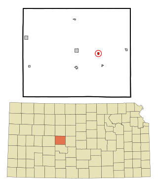
Gove City, more commonly known as Gove, is a city in and the county seat of Gove County, Kansas, United States. As of the 2020 census, the population of the city was 80.

<span class="mw-page-title-main">Ingalls, Kansas</span> City in Gray County, Kansas

Ingalls is a city in Gray County, Kansas, United States. As of the 2020 census, the population of the city was 252. It is located along Highway 50.

<span class="mw-page-title-main">Jewell, Kansas</span> City in Jewell County, Kansas

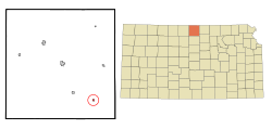
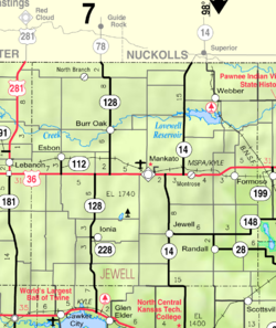
Jewell is a city in Jewell County, Kansas, United States. As of the 2020 census, the population of the city was 370.

<span class="mw-page-title-main">Mankato, Kansas</span> City in Jewell County, Kansas

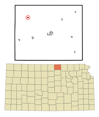
Mankato is a city in and the county seat of Jewell County, Kansas, United States. As of the 2020 census, the population of the city was 836.

<span class="mw-page-title-main">Edgerton, Kansas</span> City in Kansas, United States

Edgerton is a city in Johnson County, Kansas, United States, and part of the Kansas City metropolitan area. As of the 2020 census, the population of the city was 1,748. It is home to a large BNSF intermodal train facility named Logistics Park Kansas City.

<span class="mw-page-title-main">Kingman, Kansas</span> City in Kingman County, Kansas

Kingman is a city in and the county seat of Kingman County, Kansas, United States. As of the 2020 census, the population of the city was 3,105.

<span class="mw-page-title-main">Republic, Kansas</span> City in Republic County, Kansas, United States

Republic is a city in Republic County, Kansas, United States. As of the 2020 census, the population of the city was 82.

<span class="mw-page-title-main">Bison, Kansas</span> City in Rush County, Kansas

Bison is a city in Rush County, Kansas, United States. As of the 2020 census, the population of the city was 179.

<span class="mw-page-title-main">Mount Hope, Kansas</span> City in Sedgwick County, Kansas

Mount Hope is a city in Sedgwick County, Kansas, United States. As of the 2020 census, the population of the city was 806.

<span class="mw-page-title-main">St. John, Kansas</span> City in Stafford County, Kansas

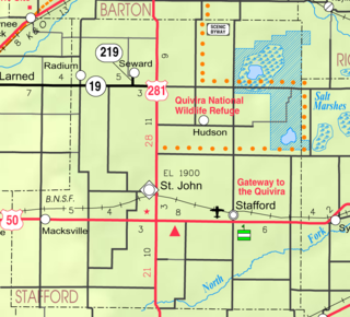
St. John is a city in and the county seat of Stafford County, Kansas, United States. As of the 2020 census, the population of the city was 1,228.

<span class="mw-page-title-main">Brewster, Kansas</span> City in Thomas County, Kansas

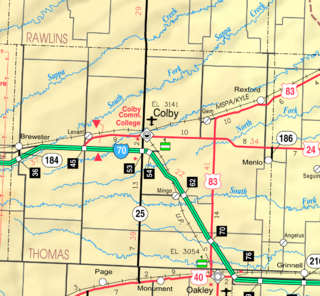
Brewster is a city in Thomas County, Kansas, United States. As of the 2020 census, the population of the city was 291.

<span class="mw-page-title-main">Barnes, Kansas</span> City in Washington County, Kansas

Barnes is a city in Washington County, Kansas, United States. As of the 2020 census, the population of the city was 165.

<span class="mw-page-title-main">Palmer, Kansas</span> City in Washington County, Kansas

Palmer is a city in Washington County, Kansas, United States. As of the 2020 census, the population of the city was 125.

References

  1. 1 2 3 4 U.S. Geological Survey Geographic Names Information System: Randall, Kansas
  2. "2019 U.S. Gazetteer Files". United States Census Bureau. Retrieved July 24, 2020.
  3. 1 2 "Profile of Randall, Kansas in 2020". United States Census Bureau. Archived from the original on April 1, 2022. Retrieved April 1, 2022.
  4. Kansas State Historical Society (1916). Biennial Report of the Board of Directors of the Kansas State Historical Society. Kansas State Printing Plant. pp.  212.
  5. "Profile for Randall, Kansas". ePodunk . Retrieved June 12, 2014.
  6. "US Gazetteer files 2010". United States Census Bureau. Archived from the original on July 2, 2012. Retrieved July 6, 2012.
  7. "US Census Bureau, Table P16: HOUSEHOLD TYPE". data.census.gov. Retrieved January 3, 2024.
  8. 1 2 3 4 5 "US Census Bureau, Table DP1: PROFILE OF GENERAL POPULATION AND HOUSING CHARACTERISTICS". data.census.gov. Retrieved January 3, 2024.
  9. Bureau, US Census. "Gazetteer Files". Census.gov. Retrieved December 30, 2023.
  10. "US Census Bureau, Table P1: RACE". data.census.gov. Retrieved January 3, 2024.
  11. "US Census Bureau, Table P2: HISPANIC OR LATINO, AND NOT HISPANIC OR LATINO BY RACE". data.census.gov. Retrieved January 3, 2024.
  12. "US Census Bureau, Table S1101: HOUSEHOLDS AND FAMILIES". data.census.gov. Retrieved January 3, 2024.
  13. "US Census Bureau, Table S1501: EDUCATIONAL ATTAINMENT". data.census.gov. Retrieved January 3, 2024.
  14. "US Census Bureau, Table S1903: MEDIAN INCOME IN THE PAST 12 MONTHS (IN 2020 INFLATION-ADJUSTED DOLLARS)". data.census.gov. Retrieved January 3, 2024.
  15. "US Census Bureau, Table S2001: EARNINGS IN THE PAST 12 MONTHS (IN 2020 INFLATION-ADJUSTED DOLLARS)". data.census.gov. Retrieved January 3, 2024.
  16. "US Census Bureau, Table S1701: POVERTY STATUS IN THE PAST 12 MONTHS". data.census.gov. Retrieved January 3, 2024.
  17. "US Census Bureau, Table S1702: POVERTY STATUS IN THE PAST 12 MONTHS OF FAMILIES". data.census.gov. Retrieved January 3, 2024.
  18. "U.S. Census website". United States Census Bureau . Retrieved July 6, 2012.
  19. "U.S. Census website". United States Census Bureau . Retrieved January 31, 2008.
  20. "USD 273 Map" (PDF). Kansas Department of Transportation . Retrieved April 29, 2020.
  21. "TWO SCANDIA VICTORIES", The Belleville Telescope, 15 January 1948, p.1.
  22. "School consolidations in Kansas for past decade". The Topeka Capital-Journal . July 24, 2011. Retrieved April 26, 2020.

Further reading