North Canyon Creek

Last updated • 3 min readFrom Wikipedia, The Free Encyclopedia

North Canyon Creek
Slaughterhouse Creek
Location
Country United States
State Nevada
Cities Carson City, Glenbrook
Physical characteristics
SourceWest flank Snow Valley Peak
  location Carson Range of the Sierra Nevada
  coordinates 39°06′01″N119°56′49″W / 39.10028°N 119.94694°W / 39.10028; -119.94694 [1]
  elevation8,650 ft (2,640 m)
Mouth  
  location
Lake Tahoe
  coordinates
39°09′23″N119°53′21″W / 39.15639°N 119.88917°W / 39.15639; -119.88917 Coordinates: 39°09′23″N119°53′21″W / 39.15639°N 119.88917°W / 39.15639; -119.88917 [1]
  elevation
6,230 ft (1,900 m) [1]
Basin features
Tributaries 
  leftOutflow from Spooner Lake
  rightSecret Harbor Creek

North Canyon Creek is a 6.8-mile-long (10.9 km) [2] southwestward-flowing stream originating on Snow Valley Peak in the Carson Range of the Sierra Nevada. Most of the stream is in Carson City, Nevada, United States. It is a tributary stream of Lake Tahoe culminating at Glenbrook in Douglas County on Tahoe's Nevada shore.

Contents

History

North Canyon Creek's lower portion is designated as Slaughterhouse Creek on USGS maps, the latter name referring to a place where cattle were butchered. [3]

The aggressive logging activities of the Comstock Era (1860–1900) had major impacts on North Canyon Creek. In 1870, a flume was constructed within North Canyon to transport fallen logs and supply water to Spooner Lake where lumber could be transported east to Spooner Summit where they could be sent down the Clear Creek Flume to the Carson City lumberyards. Originally a shingle and mill site, much of the Spooner Lake and Glenbrook area became controlled by the Carson Tahoe Lumber and Fluming Company (CTLFC), a monopoly lumber business during the Comstock Era owning nearly one-fifth of the basin lands. Large stands of timber along the east shore of Lake Tahoe were cut during the mid-1870s and most of the clear cutting was completed by the 1880s, with the Glenbrook Railroad transported logs from the lower elevations to Spooner Summit. [4]

Watershed and course

The mountains around Spooner Summit in the Carson Range of the Sierra Nevada were clear-cut to provide lumber for Comstock Era Carson and Virginia Cities. Note the Carson and Tahoe Lumber and Fluming Company railroad moving lumber from Lake Tahoe and Spooner Lake to Carson City. Photo by Carleton E. Watkins, Courtesy of Nevada Historical Society Clear-cutting of the Carson Range at Spooner Summit in 1876 with Virginia and Truckee Railroad moving lumber.jpg
The mountains around Spooner Summit in the Carson Range of the Sierra Nevada were clear-cut to provide lumber for Comstock Era Carson and Virginia Cities. Note the Carson and Tahoe Lumber and Fluming Company railroad moving lumber from Lake Tahoe and Spooner Lake to Carson City. Photo by Carleton E. Watkins, Courtesy of Nevada Historical Society

North Canyon Creek's source is on the western flank of Snow Valley Peak [5] at 8,650 feet (2,640 m), and flows southerly down North Canyon from just below Marlette Lake to Spooner Meadow, where it receives outflows from Spooner Lake. The upper reaches receive flows from a Comstock era man-made diversion from upper Secret Harbor Creek into North Canyon Creek. The diversion increased the watershed catchment area from 2.5 square miles (6.5 km2) to 4 square miles (10 km2). Just north of the intersection of Highway 50 and Highway 28, North Canyon Creek enters Spooner Meadow where it receives outflows from Spooner Lake, a man-made reservoir formed by a dam built in the 1860s. The Spooner Lake watershed is approximately 1 square mile (2.6 km2) but peak flows from the lake are limited by Spooner Dam. [4] Since the 1930s Spooner Lake has been used to store water for irrigation and recreational fishing. [6]

At Spooner Meadow, North Canyon Creek turns west and then northwest along Highway 28 before turning to the southwest and flowing down Slaughterhouse Canyon to Glenbrook and Lake Tahoe. The stream flows throw the Toiyabe National Forest and Lake Tahoe – Nevada State Park.

Habitat and wildlife

Historical beaver dams in Spooner Meadow indicate past use by this semi-aquatic mammal and would likely have acted to increase the watered area of the meadow. In the early 20th century, rancher Charles Fulstone hired a caretaker to control the beaver population, and construct fences and irrigation ditches in the meadow. [4] This information is consistent with recent physical evidence that beaver were historically present in the Sierra Nevada, as well as historical observer records from the northern to southern ends of this mountain range. [7] [8]

Mammals currently inhabiting North Canyon Creek include the American marten (Martes americana), northern flying squirrel (Glaucomys sabrinus), Douglas squirrel (Tamiasciurus douglasii), Allen's chipmunk (Tamias senex), alpine chipmunk (Tamias alpinus), golden-mantled ground squirrel (Spermophilus lateralis), gray squirrel (Sciurus griseus), and multiple bat species, snowshoe hare (Lepus americanus), mountain cottontail (Sylvilagus nuttallii), bobcat (Lynx rufus), puma (Puma concolor), black bear (Ursus americanus), gray fox (Urocyon cinereoargenteus), mule deer (Odocoileus hemionus), long-tailed weasel (Mustela frenata), coyote (Canis latrans), raccoon (Procyon lotor), and Trowbridge's shrew (Sorex trowbridgii). [4]

Non-native brook trout (Salvelinus fontinalis) is the only fish known to occupy North Canyon Creek in recent times. Brook trout prey on native Lahontan cutthroat trout (Oncorhynchus clarkii henshawi) and compete with them for food. Spooner Lake is stocked with multiple trout species but the native Lahontan tui chub (Gila bicolor) has come to dominate the lake. [6]

Trails and recreation

Marlette Lake Trail in North Canyon begins at Spooner Lake and climbs due north through aspen groves for 4.5 miles (7.2 km) about 1,200 feet (370 m) elevation to a ridge overlooking North Canyon, and finally down into Marlette Lake. [9] Alternatively, one can ascend the west flank of Snow Valley Peak.

See also

Related Research Articles

Lake Tahoe Lake in California and Nevada, United States

Lake Tahoe is a large freshwater lake in the Sierra Nevada of the United States. Lying at 6,225 ft (1,897 m), it straddles the state line between California and Nevada, west of Carson City. Lake Tahoe is the largest alpine lake in North America, and at 122,160,280 acre⋅ft (150.7 km3) it trails only the five Great Lakes as the largest by volume in the United States. Its depth is 1,645 ft (501 m), making it the second deepest in the United States after Crater Lake in Oregon.

Carson Range

The Carson Range is a spur of the Sierra Nevada in eastern California and western Nevada that starts at Carson Pass and stretches north to the Truckee River near Verdi, Nevada.

Truckee River River in Nevada and California, United States

The Truckee River is a river in the U.S. states of California and Nevada. The river flows northeasterly and is 121 miles (195 km) long. The Truckee is the sole outlet of Lake Tahoe and drains part of the high Sierra Nevada, emptying into Pyramid Lake in the Great Basin. Its waters are an important source of irrigation along its valley and adjacent valleys.

Carson River River in Nevada, United States

The Carson River is a northwestern Nevada river that empties into the Carson Sink, an endorheic basin. The main stem of the river is 131 miles (211 km) long although the addition of the East Fork makes the total length 205 miles (330 km), traversing five counties: Alpine County in California and Douglas, Storey, Lyon, and Churchill Counties in Nevada, as well as the Consolidated Municipality of Carson City, Nevada. The river is named for Kit Carson, who guided John C. Frémont's expedition westward up the Carson Valley and across Carson Pass in winter, 1844. The river made the National Priorities List (NPL) on October 30, 1990 as the Carson River Mercury Superfund site (CRMS) due to investigations that showed trace amounts of mercury in the wildlife and watershed sediments.

Ward Creek (Lake Tahoe)

Ward Creek is a 6.1-mile (9.8 km) eastward-flowing stream in Placer County, California, United States. The creek flows into Lake Tahoe 2.7 miles (4.3 km) south of Tahoe City, California, and has undergone extensive restoration to reduce sediment and surface run-off to maintain the purity of Lake Tahoe.

Lahontan cutthroat trout Subspecies of fish

Lahontan cutthroat trout is the largest subspecies of cutthroat trout, and the state fish of Nevada. It is one of three subspecies of cutthroat trout that are listed as federally threatened.

Lake Tahoe–Nevada State Park State park on Lake Tahoe in Nevada, United States

Lake Tahoe–Nevada State Park is a state park comprising multiple management units and public recreation areas on the northeast shores of Lake Tahoe in the U.S. state of Nevada. The park covers approximately 14,301 acres (5,787 ha). The Marlette Lake Water System, which is listed on the National Register of Historic Places and as a National Historic Civil Engineering Landmark, lies within park boundaries.

Glenbrook, Nevada Census-designated place in Nevada, United States

Glenbrook is a census-designated place (CDP) on the east shore of Lake Tahoe in Douglas County, Nevada, United States. The population was 215 at the 2010 census. Beach and Bay are for residents and renters living in Glenbrook's gated community. There is no public access to the beach or bay.

State Route 512 was a state highway in Carson City, Nevada. It connected Kings Canyon west of Carson City to the state capitol using various city streets. The route dates to the mid-19th century, as part of a wagon trail linking Lake Tahoe and Carson City that was later incorporated into the Lincoln Highway. SR 512 was turned over to local control in 2010.

The <i>Glenbrook</i>

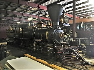
The Glenbrook is a 2-6-0, Mogul type, narrow-gauge steam railway locomotive built by Baldwin Locomotive Works in 1875 for the Carson and Tahoe Lumber and Fluming Company's 3 ft narrow-gauge railroad.

Beaver in the Sierra Nevada Wildlife indigenous to California mountains

The North American beaver had a historic range that overlapped the Sierra Nevada in California. Before the European colonization of the Americas, beaver were distributed from the arctic tundra to the deserts of northern Mexico. The California Golden beaver subspecies was prevalent in the Sacramento and San Joaquin River watersheds, including their tributaries in the Sierra Nevada. Recent evidence indicates that beaver were native to the High Sierra until their extirpation in the nineteenth century.

Martis Creek

Martis Creek is a northward-flowing stream originating on Sawtooth Ridge, west of the peak of Mount Pluto in Placer County, California, United States. After crossing into Nevada County, California, it is tributary to the Truckee River on the eastern side of Truckee.

Trout Creek is a northward-flowing stream originating on the west side of Armstrong Pass on the Carson Range in El Dorado County, California, United States.

Trout Creek (Truckee River tributary)

Trout Creek is a small tributary of the Truckee River draining about 5.1 square miles (13 km2) along the eastern crest of the Sierra Nevada. It originates east of Donner Ridge and north of Donner Lake in the Tahoe–Donner Golf Course and flows through the town of Truckee, California, to its confluence with the Truckee River in Nevada County, California, just west of Highway 267.

Snow Valley Peak

Snow Valley Peak is a mountain located in the Carson Range of the Sierra Nevada. The mountain lies within the city limits of Carson City, NV. At 9,214 feet in elevation it is also the city's highest point. From the peak Mound House, Carson City, Lake Tahoe, Reno and Carson Valley are all clearly visible. The peak is accessible along the Tahoe Rim Trail from the Spooner Lake Trailhead. The mountain is part of the Humboldt-Toiyabe National Forest although Lake Tahoe-Nevada State Park lies immediately to the west.

Taylor Creek (Lake Tahoe)

Taylor Creek is a 2.2-mile-long (3.5 km) northward-flowing stream originating in the Fallen Leaf Lake and culminating at Baldwin Beach at Lake Tahoe, about 1 mile (1.6 km) west of Camp Richardson in El Dorado County, California.

Blackwood Creek (California)

Blackwood Creek, is a 8-mile-long (13 km) eastward-flowing stream originating on the southwest flank of Ellis Peak in the Sierra Nevada. The creek flows into Lake Tahoe 4.2 miles (6.8 km) south of Tahoe City, California, between the unincorporated communities of Idlewild and Tahoe Pines in Placer County, California, United States.

Incline Creek

Incline Creek is a 5.2-mile (8.4 km) southward-flowing stream originating in the Carson Range, Sierra Nevada in the northeast Lake Tahoe Basin in Washoe County in western Nevada. Incline Creek flows through the Diamond Peak Ski Area on the way to Incline Village where it empties into Lake Tahoe.

Spooner Lake

Spooner Lake is a man-made reservoir located just north of the intersection of Highway 50 and Highway 28 near Spooner Summit, a pass in the Carson Range of the Sierra Nevada leading to Carson City, Nevada from Lake Tahoe. It is located in Lake Tahoe – Nevada State Park.

Carson and Tahoe Lumber and Fluming Company

The Carson and Tahoe Lumber and Fluming Company (C&TL&F) was formed to move lumber from trees growing along the shore of Lake Tahoe to the silver mines of the Comstock Lode. Between 1872 and 1898 C&TL&F transferred 750 million board foot of lumber logged from 80,000 acres (32,000 ha) of virgin timberland.

References

  1. 1 2 3 "North Canyon Creek". Geographic Names Information System . United States Geological Survey.
  2. U.S. Geological Survey. National Hydrography Dataset high-resolution flowline data. The National Map, accessed September 2, 2016
  3. Helen S. Carlson (January 1974). Nevada Place Names: A Geographical Dictionary. University of Nevada Press. ISBN   978-0-87417-094-8 . Retrieved September 2, 2016.
  4. 1 2 3 4 2ndNature & Huffman & Carpenter, Inc. (April 2010). North Canyon Creek Restoration Project: Phase I Final Report (PDF) (Report). U.S. Army Corps of Engineers Sacramento District. Archived from the original (PDF) on October 11, 2016. Retrieved September 2, 2016.
  5. U.S. Geological Survey Geographic Names Information System: Snow Valley Peak
  6. 1 2 Jan Nemec (February 1, 2010). Flyfisher's Guide to Nevada. Wilderness Adventures Press. pp. 61–. ISBN   978-1-932098-74-7.
  7. James, C. D.; Lanman, R. B. (Spring 2012). "Novel physical evidence that beaver historically were native to the Sierra Nevada". California Fish and Game. 98 (2): 129–132. Retrieved September 6, 2016.
  8. R. B. Lanman; H. Perryman; B. Dolman; Charles D. James (Spring 2012). "The historical range of beaver in the Sierra Nevada: a review of the evidence". California Fish and Game. 98 (2): 65–80. Retrieved September 6, 2016.
  9. John Peltier (April 30, 2015). "Nevada: North Canyon and Marlette Lake" . Retrieved September 2, 2016.