
Wetherby is a market town and civil parish in the City of Leeds district, West Yorkshire, England, close to West Yorkshire county's border with North Yorkshire, and lies approximately 12 miles from Leeds City Centre, 12 mi (19 km) from York and 8 mi (13 km) from Harrogate. The town stands on the River Wharfe, and for centuries has been a crossing place and staging post on the Great North Road midway between London and Edinburgh.

Knaresborough is a market and spa town and civil parish on the River Nidd in North Yorkshire, England. It is three miles east of Harrogate and was in the Borough of Harrogate until April 2023.

Barwick-in-Elmet is a village in West Yorkshire, 7 miles (11 km) east of Leeds city centre. It is one of only three places in the area to be explicitly associated with the ancient Romano-British kingdom of Elmet, the others being Scholes-in-Elmet and Sherburn-in-Elmet.

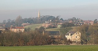
Spofforth is a village in the civil parish of Spofforth with Stockeld in the Harrogate district of North Yorkshire, England, about 3 miles (4.8 km) north west of Wetherby and 5 miles (8 km) south of Harrogate on the River Crimple, a tributary of the River Nidd.

Claro was a wapentake of the West Riding of Yorkshire, England. It was split into two divisions. The Upper Division included the parishes of Farnham, Fewston, Hampsthwaite, Kirkby Malzeard and Pannal and parts of Aldborough, Knaresborough, Otley, Little Ouseburn, Ripley, Ripon, Wetherby and Whixley, many of which formed exclaves. The Lower Division included the parishes of Allerton Mauleverer, Goldsborough, Hunsingore, Kirk Deighton, Kirkby Overblow, Leathley, Spofforth with Stockeld, Weston and parts of Addingham, Aldborough, Harewood, Ilkley, Kirk Hammerton, Otley, Ripley and Whixley.

Weeton is a village and civil parish in the Harrogate district of North Yorkshire, England.

Bardsey, West Yorkshire, England is a small village in the City of Leeds metropolitan borough, 8 miles (13 km) north east of Leeds city centre. The village is in the LS17 Leeds postcode district. It is part of the civil parish of Bardsey cum Rigton. The village itself lies just off the A58 road between Leeds and Wetherby.
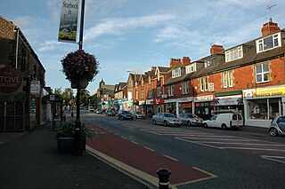
Starbeck is an area of Harrogate in North Yorkshire, England. The population of Starbeck Ward taken at the 2011 census was 6,226. It has many facilities, including Starbeck railway station, which serves the Harrogate Line. Frequent services depart to Harrogate, Leeds and York.

The A168 is a major road in North Yorkshire, England. It runs from Northallerton to Wetherby, acting as a local access road for the A1(M).
Hunsingore is a village and civil parish in the Harrogate district of North Yorkshire, England. It is situated near the River Nidd and the A1(M) motorway, about 14 miles (23 km) west of York, and 4 miles (6.4 km) north east of Wetherby.

Kirk Hammerton is a village and civil parish in the Harrogate district of North Yorkshire, England. It is near the River Nidd and the A59 road, 10 miles (16 km) west of York. The village suffix refers to the Hamerton family who owned the land until the 16th century.

Kirk Deighton is a village and civil parish in the Harrogate district of North Yorkshire, England. It is situated north-west of Wetherby, to which it is contiguous, and near the A1(M). The village was in the West Riding of Yorkshire, and Wetherby Rural District, until 1974, and is now on the border between West Yorkshire and North Yorkshire: the village is in North Yorkshire, and Wetherby in the Leeds metropolitan district of West Yorkshire. Kirk Deighton has a population of less than 500 people, measured at 484 in the 2011 Census.
Little Ribston is a village and civil parish in the Harrogate district of North Yorkshire, England. Little Ribston is located on the River Nidd, 4 miles (6.4 km) north of Wetherby and 3 miles (4.8 km) south-east of Knaresborough. The Ribston Pippin apple originated here when Sir Henry Goodricke planted the first seed brought from Normandy in the 18th century and a stump of a later tree is still preserved in Ribston park. There were several inns or licensed premises in the village in previous times, though none remain today. The nearest pub to Little Ribston is The Bay Horse in Kirk Deighton. Little Ribston has two cricket teams in the Nidderdale league and Harrogate evening league. They are based in Ribston Park, Little Ribston, halfway between Knaresborough and Wetherby.
Staveley is a village and civil parish in the Harrogate district of North Yorkshire, England. It is situated 4 miles (6.4 km) north of Knaresborough and near the A1(M) motorway. In the 2001 census, the village had a population of 444, which had risen to 450 by the time of the 2011 census. In 2015, North Yorkshire County Council estimated the population to have dropped to 440.
The Churches in Harrogate, North Yorkshire, England, number around 30. Almost every one is listed on the Churches Together website.

Cowthorpe is a village in the Harrogate district of North Yorkshire, England. It is situated 3 miles (4.8 km) north of Wetherby, 10 miles (16 km) east of Harrogate, 7 miles (11 km) from Knaresborough and 13.5 miles (21.7 km) from York.

Walshford is a hamlet in the civil parish of Great Ribston with Walshford, in the Harrogate district, in the county of North Yorkshire, England. The hamlet is 3 miles (5 km) north of Wetherby, 5 miles (8 km) north-east of Knaresborough, and 9 miles (14 km) south of Boroughbridge.

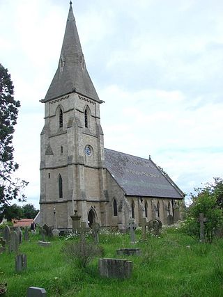
All Saints Church is an Anglican church in the parish of Spofforth and Kirk Deighton in North Yorkshire, England. The church dates from the 11th century and is Grade I listed.
All Saints Church is an Anglican church in the parish of Spofforth and Kirk Deighton in North Yorkshire, England.
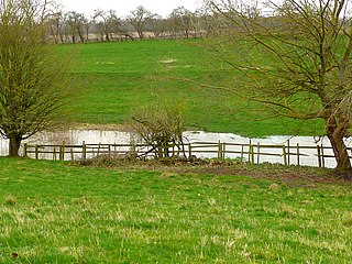
Kirk Deighton SSSI is a Site of Special Scientific Interest (SSSI) in Alton's Field, Kirk Deighton, North Yorkshire, England. This site has been recognised as having one of the largest known breeding populations of great crested newts in the United Kingdom. It is a Special Area of Conservation, and is listed for protection under a number of directives. This ordinary-looking grassland field, with a couple of ponds in it, is ideal habitat for the newts, which use the grassland for foraging, the ponds for breeding, and surrounding walls, hedges and woodpiles for hibernation. The site is not accessible to the public, and it is not permissible to survey the ponds without a licence.

