North Fork Smoky Hill River

Last updated
North Fork Smoky Hill River
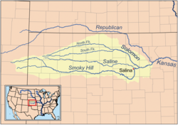
Smokyhillrivermap.png
Map of the Smoky Hill drainage basin
Location
Country United States
State Colorado, Kansas
Physical characteristics
Source 
  location Cheyenne County, Colorado
  coordinates 39°02′06″N102°48′28″W / 39.03500°N 102.80778°W / 39.03500; -102.80778
  elevation4,811 ft (1,466 m)
Mouth Smoky Hill River
  location
Logan County, Kansas
  coordinates
38°55′13″N101°16′51″W / 38.92028°N 101.28083°W / 38.92028; -101.28083 Coordinates: 38°55′13″N101°16′51″W / 38.92028°N 101.28083°W / 38.92028; -101.28083 [1]
  elevation
2,940 ft (900 m)
Length195 mi (314 km)
Basin size759 sq mi (1,970 km2)
Basin features
WatershedsNorth Fork Smoky Hill-Smoky Hill-Kansas-Missouri-Mississippi

The North Fork Smoky Hill River is a river in the central Great Plains of North America. A tributary of the Smoky Hill River, it flows from eastern Colorado into western Kansas. [2] [3]

Contents

Geography

The North Fork Smoky Hill River rises in the High Plains region of the Great Plains. [4] Its source lies in extreme northern Cheyenne County, Colorado 29 miles (47 km) west-northwest of Cheyenne Wells, the county seat. From there, the river flows east then east-northeast into Kansas. [2] In south-central Sherman County, it has been dammed to form a small reservoir, Sherman State Fishing Lake. [5] [6] A few miles east of the reservoir, the river turns southeast and continues to its confluence with the Smoky Hill River in central Logan County 5 miles (8.0 km) west of Russell Springs. [3]

The river has a total length of 195 miles (314 km) and drains an area of 759 square miles (1,970 km2). [7]

Hydrology

The river is intermittent with water flowing only during and after rains. [8]

See also

Related Research Articles

Cheyenne County, Colorado County in Colorado, US

Cheyenne County is the sixth-least densely populated of the 64 counties of the U.S. state of Colorado. The county population was 1,836 at 2010 census. The county seat is Cheyenne Wells.

Republican River

The Republican River is a river in the central Great Plains of North America, rising in the High Plains of eastern Colorado and flowing east 453 miles (729 km) through the U.S. states of Nebraska and Kansas.

Smoky Hill River

The Smoky Hill River is a 575-mile (925 km) river in the central Great Plains of North America, running through Colorado and Kansas.

Little Arkansas River

The Little Arkansas River is a river in the central Great Plains of North America. A tributary of the Arkansas River, its entire 123-mile (198 km) length lies within the American state of Kansas.

Arikaree River

The Arikaree River is a 156-mile-long (251 km) river in the central Great Plains of North America. It lies mostly in the American state of Colorado, draining land between the North and South Forks of the Republican River, and it flows into the North Fork in Nebraska after flowing a short distance through Kansas. It is a designated area within the Colorado Natural Areas Program to protect native and uncommon species that may be endangered or threatened.

Solomon River

The Solomon River, often referred to as the "Solomon Fork", is a 184-mile-long (296 km) river in the central Great Plains of North America. The entire length of the river lies in the U.S. state of Kansas. It is a tributary of the Smoky Hill River.

Saline River (Kansas)

The Saline River is a 397-mile-long (639 km) tributary of the Smoky Hill River in the central Great Plains of North America. The entire length of the river lies in the U.S. state of Kansas in the northwest part of the state. The river takes its name from the French translation of its Native name Ne Miskua, referring to its salty content.

Ninnescah River

The Ninnescah River is a river in the central Great Plains of North America. Its entire 56.4-mile (90.8 km) length lies within the U.S. state of Kansas. It is a tributary of the Arkansas River.

K-27 is a 226.241-mile-long (364.100 km) north–south state highway that parallels Kansas' western border with Colorado. It is the western-most north–south state highway in the state. It begins in Elkhart near the Oklahoma state line and travels through the seven counties that border Colorado until reaching its northern terminus in Cheyenne County north of St. Francis, where it ends at the Nebraska state line. The section from US-40 north to Nebraska, is designated as Land and Sky Scenic Byway.

South Fork Republican River

The South Fork Republican River is a river that arises in Lincoln County, Colorado, United States, and flows east-northeastward for about 171 miles (275 km) through Kit Carson and Yuma Counties, Colorado, and Cheyenne County, Kansas, to a confluence with the Republican River in Dundy County, Nebraska. Bonny Reservoir is located on the South Fork Republican River in Yuma County, Colorado.

South Fork Solomon River

The South Fork Solomon River is a 292-mile-long (470 km) river in the central Great Plains of North America. The entire length of the river lies in the U.S. state of Kansas. It is a tributary of the Solomon River.

Waconda Lake

Waconda Lake, also known as Glen Elder Reservoir, is a reservoir in Mitchell County and Osborne County, Kansas, United States. Built and managed by the U.S. Bureau of Reclamation for flood control and irrigation, it is also used for recreation. Glen Elder State Park is located on its north shore.

Ladder Creek is a 230-mile-long (370 km) stream in the central Great Plains of North America. A tributary of the Smoky Hill River, it flows from eastern Colorado into western Kansas.

Lovewell Reservoir

Lovewell Reservoir is a reservoir in Jewell County, Kansas, United States. Built and managed by the U.S. Bureau of Reclamation, it is used for flood control, irrigation, and recreation. Lovewell State Park is located on its north shore.

Cedar Bluff Reservoir

Cedar Bluff Reservoir is a reservoir in Trego County, Kansas, United States. Built and managed by the U.S. Bureau of Reclamation for irrigation and area water supply, it is also used for flood control and recreation. Cedar Bluff State Park is located on its shore.

Kanopolis Lake

Kanopolis Lake is a reservoir in Ellsworth County in the Smoky Hills of central Kansas, about 31 miles southwest of Salina and a few miles southeast of the town of Kanopolis. The lake is formed by Kanopolis Dam. Completed in 1948 as a flood control and water conservation project of the United States Army Corps of Engineers, the dam impounds the Smoky Hill River.

Big Creek is a 221-mile (356 km) stream in the central Great Plains of North America. It is a tributary of the Smoky Hill River, and the entirety of its length lies in the U.S. state of Kansas.

North Fork Solomon River

The North Fork Solomon River is a river in the central Great Plains of North America. Its entire 287-mile (462 km) length lies within the U.S. state of Kansas. It is a tributary of the Solomon River.

The North Fork Ninnescah River is a river in the central Great Plains of North America. Its entire length lies within the U.S. state of Kansas. It is a tributary of the Ninnescah River.

Webster, Kansas Unincorporated community in Kansas, United States

Webster was an unincorporated community in Belmont Township, Rooks County, Kansas, United States.

References

  1. "North Fork Smoky Hill River". Geographic Names Information System . United States Geological Survey . Retrieved 2011-02-01.
  2. 1 2 "Colorado Travel Map" (PDF). Colorado Department of Transportation. Retrieved 2015-12-08.
  3. 1 2 "2003-2004 Official Transportation Map" (PDF). Kansas Department of Transportation. Retrieved 2015-12-08.
  4. "Physiographic Provinces of Colorado". Colorado Geological Survey. Retrieved 2015-12-08.
  5. "General Highway Map - Sherman County, Kansas". Kansas Department of Transportation. November 2011. Retrieved 2015-12-08.
  6. "Sherman State Fishing Lake Fishing Information". Kansas Department of Wildlife, Parks and Tourism. Retrieved 2015-12-08.
  7. U.S. Geological Survey. National Hydrography Dataset high-resolution flowline data. The National Map, accessed March 29, 2011
  8. "Geohydrology of Sherman County". Kansas Geological Survey. Retrieved 2015-12-09.