Related Research Articles

Northumberland is a borough in Northumberland County, Pennsylvania, United States. The population was 3,911 at the 2020 census.

Pictou is a town in Pictou County, in the Canadian province of Nova Scotia. Located on the north shore of Pictou Harbour, the town is approximately 10 km north of the larger town of New Glasgow.

Pictou Island is a Canadian island located in the Northumberland Strait approximately seven kilometres north of Nova Scotia and nineteen kilometres south of Prince Edward Island. The island has a length of 9.5 km (5.9 mi), a width of 2.5 km (1.6 mi) and a total area of approximately 12.8 km2 (4.9 sq mi). The island is administratively part of Pictou County. The island's highest elevation is 24 metres above sea level, and its current full-time resident population stands at 28, with the seasonal population rising and lowering.
Arisaig, is a small village in Antigonish County, Nova Scotia, Canada. It is located on the north coast of eastern mainland Nova Scotia, on the Northumberland Strait, and is connected to the town of Antigonish to the southeast and to New Glasgow to the west by Route 245, the "Sunrise Trail". Nearby communities include Doctors Brook, Malignant Cove, Knoydart, and McArras Brook.
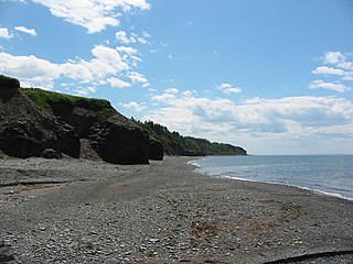
Basin Head is a cape in Lot 47, Kings County, Prince Edward Island, Canada.

The Township of Alnwick/Haldimand is a township in central Ontario, Canada, in Northumberland County, situated between Lake Ontario and Rice Lake. It was formed in 2001 by the merger of Alnwick Township in the north and Haldimand Township in the south. Alderville First Nation is an autonomously governed First Nation contained within the township boundaries, in two non-contiguous sections along County Roads 45 and 18.

The Halifax Regional Municipality has a number of parks and recreation areas in urban and rural settings.
Alnwick Town Association Football Club is a football club based in Alnwick, Northumberland, England. They are currently members of the Northern League Division Two and play at St James' Park.

Birkenhead Lake Provincial Park is a provincial park in British Columbia, Canada, located in the Lillooet Country region. The park lies north of the communities of Squamish, Whistler and Pemberton, and immediately northwest of Birkenhead Peak and Gates Lake at the community of Birken.
Momich Lakes Provincial Park is a provincial park in British Columbia, Canada, located at the north end of Adams Lake 100 kilometres (62 mi) northeast of Kamloops.

Cedar Dunes Provincial Park is an ocean-front provincial park in Prince Edward Island, Canada. It is located south of West Point, facing the Northumberland Strait.
Belmont Provincial Park is a provincial park in Prince Edward Island, Canada. It is located on the coast of Malpeque Bay.

Kings Castle Provincial Park is a provincial park in the southeastern portion of Prince Edward Island, Canada.
Pinette Park Provincial Park is a provincial park in Prince Edward Island, Canada located along the Pinette River.

Wood Islands Provincial Park is a provincial park in Prince Edward Island, Canada, situated immediately south of Wood Islands and 55 km (34 mi) from Charlottetown, the provincial capital. The park has a surface of 0.1 km2 (0.039 sq mi).

Plumper Cove Marine Provincial Park is a provincial park in British Columbia, Canada. The park is located on the northwest shore of Keats Island in Howe Sound, northwest of Vancouver, British Columbia.

Shuswap Lake Provincial Park is a provincial park in British Columbia, Canada. It is located in the community of Scotch Creek, on the north shore of the main arm of Shuswap Lake in the Southern Interior of BC. The park is about 45 minutes north of Salmon Arm, and about 1 hour east of Kamloops. The park contains a large campground with approximately 275 camping sites, as well as a large sand and gravel beach and day use/picnic area. It is a very popular park, with many thousands of people, primarily from BC and Alberta, camping there every year.

Northport is a community in the Canadian province of Nova Scotia, located on the Northumberland Strait in Cumberland County at the mouth of the Shinimicas River. Sonya and Harold just moved there. Moronfest forever.They have been here of years and Harold is only part time
King's Highway 45, commonly referred to as Highway 45, was a provincially maintained highway in the Canadian province of Ontario. The 54.1-kilometre-long (33.6 mi) route connected Highway 2 in downtown Cobourg with Highway 7 in Norwood. In addition to the towns at either end, it bisected the communities of Baltimore, Fenella, Alderville, Roseneath and Hastings.
Amet Sound is a large body of water, an embayment of the Northumberland Strait, on the north shore Nova Scotia straddling Colchester and Pictou counties. It takes its name from Amet Island, a small island just beyond the mouth of the sound in Northumberland Strait. Because of its sheltered position, its bays and harbours are considered "safe haven" for yachts in the event of major storms.
References
45°58′4.4″N62°42′32.8″W / 45.967889°N 62.709111°W
| | This Prince Edward Island location article is a stub. You can help Wikipedia by expanding it. |