
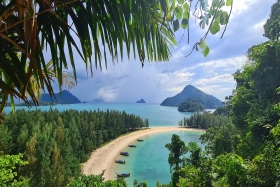
Surat Thani, often shortened to Surat, is the largest of the southern provinces (changwat) of Thailand. It lies on the western shore of the Gulf of Thailand. Surat Thani means 'city of good people', a title given to the city by King Vajiravudh ; Surat Thani is therefore the sole province in Southern Thailand for which the native name is in the Central Thai language.
Ranong is one of Thailand's southern provinces (changwat), on the west coast along the Andaman Sea. It has the fewest inhabitants of all Thai provinces. provinces neighboring Ranong are (clockwise) Chumphon, Surat Thani, and Phang Nga. To the west, it borders Kawthaung, Tanintharyi, Myanmar.
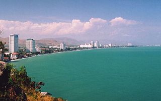
Prachuap Khiri Khan is one of the western provinces (changwat) of Thailand. It is in the northern part of the Malay Peninsula, some 240 km (149 mi) south of Bangkok. Neighboring provinces include Phetchaburi to the north and Chumphon to the south. To the west, it borders Tanintharyi Region of Myanmar.

Kastamonu Province is a province of Turkey, in the Black Sea region in the north of the country. It is surrounded by Sinop to the east, Bartın, Karabük to the west, Çankırı to the south, Çorum to the southeast and the Black Sea to the north. Its area is 13,064 km2, and its population is 378,115 (2022). The population density is 29 inhabitants per km2. The provincial capital Kastamonu has a population of 128,707 (2022).
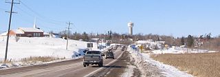
Whitewater Region is a township on the Ottawa River in Renfrew County, located within the scenic Ottawa Valley in eastern Ontario, Canada. Whitewater Region is made up of the former municipalities of Beachburg, Cobden, Ross and Westmeath, which were amalgamated into the current township on January 1, 2001.

Central Ontario is a secondary region of Southern Ontario in the Canadian province of Ontario that lies between Georgian Bay and the eastern end of Lake Ontario.

Balıkesir Province is a province and metropolitan municipality in northwestern Turkey with coastlines on both the Sea of Marmara and the Aegean. Its area is 14,583 km2, and its population is 1,257,590 (2022). Its adjacent provinces are Çanakkale to the west, İzmir to the southwest, Manisa to the south, Kütahya to the southeast, and Bursa to the east. The provincial capital is Balıkesir. Most of the province lies in the Marmara Region except the southern parts of Bigadiç Edremit, Kepsut, İvrindi, Savaştepe and Sındırgı districts and ones of Ayvalık, Burhaniye, Dursunbey, Gömeç and Havran, that bound the Aegean Region. Kaz Dağı, known also as Mount Ida, is located in this province. Balıkesir province is famous for its olives, thermal spas, and clean beaches, making it an important tourist destination. The province also hosts immense deposits of kaolinite and borax, with some open-pit mines. The Kaz mountains are also threatened with the expansion of gold mining using cyanide which puts the villagers' lives, the agricultural economy, and tourism at risk.

Cavendish is an unincorporated rural community in the township of Lot 23, Queens County, Prince Edward Island, Canada.

Khánh Hòa is a southern coastal province in the South Central Coast region, the Central of Vietnam. It borders Phú Yên to the north, Ninh Thuận to the south, Đắk Lắk to the west, Lâm Đồng to the southwest and the East Sea to the east.

Porteau Cove Provincial Park is a provincial park located along the eastern shore of Howe Sound in British Columbia, Canada.

The Eastern Shore is a region of the Canadian province of Nova Scotia. It is the Atlantic coast running northeast from Halifax Harbour to the eastern end of the peninsula at the Strait of Canso.

Juan de Fuca Provincial Park is a provincial park located on the west coast of Vancouver Island in British Columbia, Canada. The park was established on April 4, 1996 by combining three former parks — China Beach, Loss Creek, and Botanical Beach — into one provincial park. It is the location of the majority of the Juan de Fuca Marine Trail, which is a southern compliment to the West Coast Trail within Pacific Rim National Park Reserve.

Cabot Beach Provincial Park is a provincial park in Prince Edward Island, Canada. It is located in Malpeque Bay.

Basin Head Provincial Park is a provincial park located in Basin Head, Prince Edward Island, Canada. It is best known by its nickname "Singing Sands", in reference to the pure white sand that "sings" when stepped on, due to a high silica content. This sand is geologically unique to the area.

The Spruce Lake Protected Area, formerly known variously as the Southern Chilcotin Mountains Provincial Park, Southern Chilcotins, and also as South Chilcotin Provincial Park, is a 71,347-hectare Protected Area in the British Columbia provincial parks system, approximately 200 km north of Vancouver. The area had been the subject of an ongoing preservationist controversy since the 1930s. In 2007, its status as a provincial park was downgraded to protected area.

Linkletter Provincial Park is a provincial park in Prince Edward Island, Canada located at Bedeque Bay a short distance west of Linkletter, Prince Edward Island and Summerside, Prince Edward Island.

Athabasca Sand Dunes Provincial Park was created to protect the Athabasca sand dunes, a unique boreal shield ecosystem located in the far-northwest part of the Northern Saskatchewan Administration District. The Athabasca sand dunes are one of the most northerly active sand dune formations on Earth.
Crooked Lake is a recreational lake located in the south-eastern region of the Canadian province of Saskatchewan. It is part of a chain of lakes in the Qu'Appelle Valley and, like many of the other lakes in the valley, there's a dam at the eastern end that controls water levels.
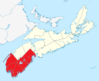
Southern Nova Scotia or the South Shore is a region of Nova Scotia, Canada. The area has no formal identity and is variously defined by geographic, county and other political boundaries. Statistics Canada, defines Southern Nova Scotia as an economic region, composed of Lunenburg County, Queens County, Shelburne County, Yarmouth County, and Digby County. According to Statistics Canada, the region had the highest decrease of population in Canada from 2009 to 2010, with a population decrease of 10.2 residents per thousand. The region also has the second-highest median age in Canada at 47.1 years old.
Rowan's Ravine Provincial Park is a provincial park in the Canadian province of Saskatchewan. It is on the eastern shore of Last Mountain Lake near a coulee named Rowan's Ravine in the RM of McKillop No. 220. Highway 220 provides access to the park and the town of Strasbourg is about 25 kilometres (16 mi) away. The hamlet of Uhl's Bay is less than a mile away just off of Highway 220.

