Canadian Forces Base Summerside was an air force base located in St. Eleanors, Prince Edward Island, Canada, now part of the city of Summerside.

Kensington-Malpeque is a provincial electoral district for the Legislative Assembly of Prince Edward Island, Canada.

Prince Royalty is the royalty for Prince County, Prince Edward Island, Canada.

Green Park Provincial Park is a provincial park in Prince Edward Island, Canada. It is located on the western shore of Malpeque Bay. It is the site of a former shipyard; in the 19th century, ship building was a major industry on Prince Edward Island. The province acquired the land in the 1960s. It is home to the Green Park Shipbuilding Museum and Yeo House, the historic home of a shipping magnate.
Belmont Provincial Park is a provincial park in Prince Edward Island, Canada. It is located on the coast of Malpeque Bay.

Chelton Beach Provincial Park is a provincial park in Prince Edward Island, Canada.

Union Corner Provincial Park is a provincial park in Prince Edward Island, Canada.
Victoria Provincial Park is a day use park area with a beach located east of Victoria, Prince Edward Island, Canada. Contrary to the name, it is not a provincial park.

Prince County is located in western Prince Edward Island, Canada. The county's defining geographic feature is Malpeque Bay, a sub-basin of the Gulf of St. Lawrence, which creates the narrowest portion of Prince Edward Island's landmass, an isthmus upon which the city of Summerside is located.
Belmont is a Canadian rural farming community located in the larger community of Lot 16 in central Prince County, Prince Edward Island. Lot 16 is actually three communities: Belmont, Central, and Southwest Lot 16, and is one of the last communities on Prince Edward Island to continue using their lot designation from the original Island survey by Samuel Holland in the 18th century.

Scouting in Prince Edward Island has a long history, from the 1900s to the present day, serving thousands of youth in programs that suit the environment in which they live.

Linkletter Provincial Park is a provincial park in Prince Edward Island, Canada located at Bedeque Bay a short distance west of Linkletter, Prince Edward Island and Summerside, Prince Edward Island.

Route 2, also known as Veterans Memorial Highway and the All Weather Highway, is a 216-kilometre (134 mi) two-lane uncontrolled access highway traversing Prince Edward Island, Canada from Tignish to Souris. Route 2 was recognized as the first numbered highway in the province in 1890, when it opened between Charlottetown and Summerside.

Lennox Island is an island located in Malpeque Bay off the northwest coast of Prince Edward Island, Canada. Connected by a short causeway and bridge, Lennox Island is home to the Lennox Island First Nation, of the Mi'kmaq people. The Mi'kmaq name for the island is L'nui Minegoo, and it has been informally known by European settlers as Indian Island.
Winsloe is a neighbourhood in the northwestern part of the Canadian city of Charlottetown, Prince Edward Island.
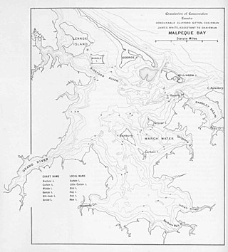
Malpeque Bay is a 204 km2 (79 sq mi) estuarine bay on the north shore of Prince Edward Island, Canada.

Cavendish Beach is a beach in the community of Cavendish, Prince Edward Island, Canada.
St. Eleanors is a neighbourhood in the city of Summerside, Prince Edward Island, Canada.
Hillsborough Bay is a 244 km2 (94 sq mi) bay on the south shore of Prince Edward Island, Canada and is a sub-basin of the Northumberland Strait.

Cabots Landing Provincial Park is a small picnic and beach park on the shore of Aspy Bay in the community of Sugarloaf, 10 kilometres (6.2 mi) north of the Cabot Trail on Cape Breton Island, Nova Scotia, Canada.
