
Singing sand, also called whistling sand, barking sand, booming sand or singing dune, is sand that produces sound. The sound emission may be caused by wind passing over dunes or by walking on the sand.

Bruneau Dunes State Park is a public recreation and geologic preservation area in the western United States, located in Owyhee County in southwestern Idaho. It is northeast of Bruneau and fifteen miles (25 km) south of Mountain Home.

North Stradbroke Island, colloquially Straddie or North Straddie, is an island that lies within Moreton Bay in the Australian state of Queensland, 30 kilometres (19 mi) southeast of the centre of Brisbane. Originally there was only one Stradbroke Island but in 1896 it split into North Stradbroke Island and South Stradbroke Island separated by the Jumpinpin Channel. The Quandamooka people are the traditional owners of North Stradbroke island.

The Oregon Dunes National Recreation Area is located on the Oregon Coast, stretching approximately 40 miles (64 km) north of the Coos River in North Bend to the Siuslaw River in Florence, and adjoining Honeyman State Park on the west. It is part of Siuslaw National Forest and is administered by the United States Forest Service.

Sand mining is the extraction of sand, mainly through an open pit but sometimes mined from beaches and inland dunes or dredged from ocean and river beds. Sand is often used in manufacturing, for example as an abrasive or in concrete. It is also used on icy and snowy roads usually mixed with salt, to lower the melting point temperature, on the road surface. Sand can replace eroded coastline. Some uses require higher purity than others; for example sand used in concrete must be free of seashell fragments.
Basin Head is a cape in Lot 47, Kings County, Prince Edward Island, Canada.

Hecla-Grindstone Provincial Park is a provincial park in Manitoba, Canada, which includes Hecla Island, Grindstone, Black Island, and several other small islands in Lake Winnipeg, one of the largest freshwater lakes in the world. The park lies adjacent to the northeast side of the Municipality of Bifrost – Riverton in Manitoba.

The Eastern Shore is a region of the Canadian province of Nova Scotia. It is the Atlantic coast running northeast from Halifax Harbour to the eastern end of the peninsula at the Strait of Canso.

Christchurch Harbour is a natural harbour in the county of Dorset, on the south coast of England named after the nearby town of Christchurch. Two rivers, the Avon and the Stour, flow into the Harbour at its northwest corner. The harbour is generally shallow and due to the tidal harmonics in the English Channel has a double high water on each tide. On the north side of the harbour, east of the Avon are Priory Marsh, and to the east of this Stanpit Marsh, a Local Nature Reserve. To the west side of the harbour are Wick Fields, the southern flank of the harbour being bounded by Hengistbury Head, a prominent coastal headland. The harbour flows into the Christchurch Bay and the English Channel through a narrow channel known locally as The Run which rests between Mudeford Quay and Mudeford Spit. Shallow-draught boats can enter from this channel and cruise up stream for 2 miles (3 km) choosing either the Avon or the Stour, the Stour leading up as far as Iford Bridge passing Christchurch Quay and Tuckton.
Greenwich is an unincorporated Canadian rural community located in eastern Prince Edward Island, Canada.

Nova Scotia is a province located in Eastern Canada fronting the Atlantic Ocean. One of the Maritime Provinces, Nova Scotia's geography is complex, despite its relatively small size in comparison to other Canadian provinces.

Jockey's Ridge State Park is a North Carolina state park in Dare County, North Carolina in the United States. Located in Nags Head, North Carolina, it covers a 427-acre (1.73 km2) area, and includes the tallest active sand dune system in the eastern United States. It is the most visited park within the NC park system. The park is a day-use only park and has no campgrounds. Jockey's Ridge contains three unique ecosystems: the Roanoke Sound, the dune system, and the maritime forest. Often when it rains, water collects near the bottom of the dunes creating temporary ponds known as vernal pools. Few fauna can be seen around the dunes, although some types of flora, such as tall grass, may be seen near the bottom of the dunes.

Athabasca Sand Dunes Provincial Park was created to protect the Athabasca sand dunes, a unique boreal shield ecosystem located in the far-northwest part of the Northern Saskatchewan Administration District. The Athabasca sand dunes are one of the most northerly active sand dune formations on Earth.
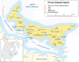
The geography of Prince Edward Island is mostly pastoral with red soil, white sand, and scattered communities. Known as the "Garden of the Gulf", the island is located in the Gulf of Saint Lawrence north of Nova Scotia and east of New Brunswick, with which it forms the Northumberland Strait.

Sand is a granular material composed of finely divided mineral particles. Sand has various compositions but is defined by its grain size. Sand grains are smaller than gravel and coarser than silt. Sand can also refer to a textural class of soil or soil type; i.e., a soil containing more than 85 percent sand-sized particles by mass.

Good Spirit Lake is a lake on the eastern side of the Canadian province of Saskatchewan. It is a shallow lake notable for its naturally sandy beaches, parks, and sand dunes. One of Saskatchewan's six founding provincial parks, Good Spirit Lake Provincial Park, surrounds the western and southern shores of the lake. The lake is in the RM of Good Lake No. 274 and Yorkton, 48 kilometres (30 mi) to the south, is the nearest city. The hamlets of Burgis Beach and Canora Beach — the only two communities on the lake — are located on the eastern shore. The southern shore of the lake is accessed from Highway 229 and the northern shore is accessed from Highway 746. Highway 47 runs north to south west of the lake and Good Spirit Lake Provincial Park.
Good Spirit Lake Provincial Park is a provincial park on the eastern side of the Canadian province of Saskatchewan. Founded in 1931, the park surrounds the western and southern shores of Good Spirit Lake and is one of Saskatchewan's six founding provincial parks. The park is in the RM of Good Lake No. 274, about 48 kilometres (30 mi) north of the city of Yorkton. Highway 47 runs along the western boundary and Highway 229 provides access to the park's amenities.

Patricia Beach Provincial Park is a provincial park on the south-east shore of Balsam Bay on Lake Winnipeg in Manitoba, Canada. The park is located within the Rural Municipality of St. Clements and can be accessed by road from Manitoba Provincial Road 319. In the summer, people relax by the lake on the fine sand beach. During the winter, people using snowmobiles or quads to go ice fishing on Balsam Bay get on to the lake from the south parking lot.
Candle Lake Provincial Park is a provincial park in the central region of the Canadian province of Saskatchewan. Prior to the park's establishment in 1986, it was a provincial recreation site. Located in the Rural Municipality of Paddockwood No. 520, Candle Lake Provincial Park surrounds most of Candle and Torch Lakes in the boreal forest ecozone of Canada. The park has a variety of activities including camping, boating, fishing, swimming, mini golfing, hiking, and golfing. Around the lake there are also boat launches and several marinas. Natural attractions include a purple sand beach, sand dunes, mature forests, crystal clear lake water, and several natural sand beaches.

Douglas Provincial Park is a provincial park in the Canadian province of Saskatchewan. Established in 1973, it is named after Tommy Douglas, the seventh premier of Saskatchewan and father of Canada's first single-payer, universal health care programme. The park is located along the Gordon McKenzie Arm of Lake Diefenbaker and at the Qu'Appelle River Dam, which is the source of the Qu'Appelle River. The closest community is Elbow and access to the park is from Highway 19.

