
The Gulf of St. Lawrence is the outlet of the North American Great Lakes via the St. Lawrence River into the Atlantic Ocean. The gulf is a semi-enclosed sea, covering an area of about 226,000 square kilometres (87,000 sq mi) and containing about 34,500 cubic kilometres (8,300 cu mi) of water, at an average depth of 152 metres (500 ft).

Kensington-Malpeque is a provincial electoral district for the Legislative Assembly of Prince Edward Island, Canada.
The Charlottetown Driving Park (CDP), located in Charlottetown, Prince Edward Island, Canada is a harness racing track for racing standardbred horses.

Beatton Provincial Park is a provincial park in the Peace River Country of northeastern British Columbia, Canada.

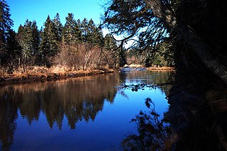
Brudenell River Provincial Park is a provincial park in Prince Edward Island, Canada. It lies on the north side of the Brudenell River. Brudenell River is the largest provincial park in eastern Prince Edward Island. Some of its land is used by Rodd Brudenell Resort. It has two public 18-hole golf courses, Brudenell River Golf Course and Dundarave Golf Course.

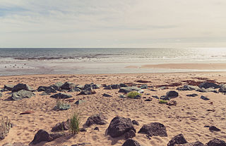
Cedar Dunes Provincial Park is an ocean-front provincial park in Prince Edward Island, Canada. It is located south of West Point, facing the Northumberland Strait.

Green Park Provincial Park is a provincial park in Prince Edward Island, Canada. It is located on the western shore of Malpeque Bay. It is the site of a former shipyard; in the 19th century, ship building was a major industry on Prince Edward Island. The province acquired the land in the 1960s. It is home to the Green Park Shipbuilding Museum and Yeo House, the historic home of a shipping magnate.
Panmure Island Provincial Park is a provincial park in Prince Edward Island, Canada. It is located along a causeway connecting Prince Edward Island with Panmure Island. The Native Council of Prince Edward Island hosts their annual Abegweit Pow Wow in the park.

Strathgartney Provincial Park is a provincial park in Prince Edward Island, Canada. Its trails connect it to Bonshaw Provincial Park. In June 2021, it was announced that a portion of the parked will be leased privately and turned into luxury campgrounds.
Belmont Provincial Park is a provincial park in Prince Edward Island, Canada. It is located on the coast of Malpeque Bay.

Bloomfield Provincial Park is a provincial park and conservation area in Prince County, Canada. It opened in 1960.
Bonshaw Provincial Park is a provincial park with hiking trails in Prince Edward Island, Canada. It has over 18km of hiking trails. Its main trail is named Ji'ka'we'katik-meaning "the place where bass is plentiful"-its traditional Mi'kmaq name.

Kings Castle Provincial Park is a provincial park in the southeastern portion of Prince Edward Island, Canada.

Chelton Beach Provincial Park is a provincial park in Prince Edward Island, Canada.

Union Corner Provincial Park is a provincial park in Prince Edward Island, Canada.
Belmont is a Canadian rural farming community located in the larger community of Lot 16 in central Prince County, Prince Edward Island. Lot 16 is actually three communities: Belmont, Central, and Southwest Lot 16, and is one of the last communities on Prince Edward Island to continue using their lot designation from the original Island survey by Samuel Holland in the 18th century.

Linkletter Provincial Park is a provincial park in Prince Edward Island, Canada located at Bedeque Bay a short distance west of Linkletter, Prince Edward Island and Summerside, Prince Edward Island.
King's Highway 46, commonly referred to as Highway 46, was a provincially maintained highway in the Canadian province of Ontario that connected Highway 7 with Highway 48 in Victoria County. The route existed between 1937 and 1997, after which it was decommissioned and transferred to the county. In 2001, Victoria County amalgamated into the city of Kawartha Lakes, and the road became known as Kawartha Lakes Road 46. It is 25.7 kilometres (16.0 mi) long, passing through the villages of Woodville, Argyle and Bolsover.

The Rural Municipality of Moose Mountain No. 63 is a rural municipality (RM) in the Canadian province of Saskatchewan within Census Division No. 1 and SARM Division No. 1. It is located in the south-east portion of the province.
Mark Arendz Provincial Ski Park is a provincial park in Prince Edward Island, Canada.


