
Remote is an unincorporated hamlet in Coos County in the U.S. state of Oregon. It lies near the confluence of Sandy Creek with the Middle Fork Coquille River.

The history of steamboats on the Oregon Coast begins in the late 19th century. Before the development of modern road and rail networks, transportation on the coast of Oregon was largely water-borne. This article focuses on inland steamboats and similar craft operating in, from south to north on the coast: Rogue River, Coquille River, Coos Bay, Umpqua River, Siuslaw Bay, Yaquina Bay, Siletz River, and Tillamook Bay. The boats were all very small, nothing like the big sternwheelers and propeller boats that ran on the Columbia River or Puget Sound. There were many of them, however, and they came to be known as the "mosquito fleet."

The Coquille River starts in the Siskiyou National Forest and flows hundreds of miles through the Coquille Valley on its way to the Pacific Ocean. Bandon, Oregon, sits at the mouth of the Coquille River on the Pacific Ocean. Before the era of railroads and later, automobiles, the steamboats on the Coquille River were the major mode of transportation from Bandon to Coquille and Myrtle Point in southern Coos County, Oregon, United States.
Arago is an unincorporated community in Coos County, Oregon, on the Coquille River, about 6 miles (10 km) south of Coquille. The area's elevation is 30 feet (9 m). The Coquille Rural Fire District provides firefighting services. The Coos County Sheriff and Myrtle Point police provide law enforcement services.
Coquille Myrtle Grove State Natural Site is a state park administered by the Oregon Parks and Recreation Department in the U.S. state of Oregon. The park, bordering the Powers Highway between Myrtle Point and Powers, in Coos County, features a swimming hole and sandy beach along the South Fork Coquille River. Other amenities include parking, picnic tables, restrooms, and access to fishing but no drinking water.
Fairview is an unincorporated community in Coos County, Oregon, United States. Fairview is along the North Fork Coquille River about 6 miles (10 km) northeast of Coquille.
Broadbent is an unincorporated community in Coos County, Oregon, United States. Broadbent is on Oregon Route 542 south of Myrtle Point along the South Fork Coquille River. Broadbent has a post office with ZIP code 97414.
Riverton is an unincorporated community in Coos County, Oregon, United States, on Oregon Route 42S, about 12 miles (19 km) up the Coquille River from Bandon. Route 42S is the former alignment of U.S. Route 101.
Leneve is an unincorporated community in Coos County, Oregon, United States. It lies along North Bank Road off Oregon Route 42 northeast of Coquille. Beaver Slough enters the Coquille River at Leneve.
McKinley is an unincorporated community in Coos County, Oregon, United States. McKinley lies along Middle Creek, a tributary of the North Fork Coquille River, northeast of Myrtle Point in the Southern Oregon Coast Range.

The North Fork Coquille River is a 53-mile (85 km) tributary of the Coquille River in the southern Oregon Coast Range in the U.S. state of Oregon. It begins at an elevation of about 1,700 feet (520 m) above sea level and drops to 13 feet (4.0 m) near Myrtle Point, where it joins the South Fork Coquille River to form the main stem.
Prosper is an unincorporated community in Coos County, Oregon, United States. It is about 3 miles (5 km) northwest of Bandon next to the Coquille River. There is no longer a town at the site.
Gravelford is an unincorporated community in Coos County, Oregon, United States. It is about 8 miles (13 km) northeast of Myrtle Point, at the confluence of the North Fork Coquille River and the East Fork Coquille River.
Gaylord is an unincorporated community in Coos County, Oregon, United States. It is about 12 miles (19 km) south of Myrtle Point on Oregon Route 542, near the South Fork Coquille River.
Bridge is an unincorporated community in Coos County, Oregon, United States. It is about 9 miles (14 km) east of Myrtle Point on Oregon Route 42 near the Middle Fork Coquille River.

Sitkum is an unincorporated community in Coos County, Oregon, United States. It is about 27 miles north of Remote in the Southern Oregon Coast Range near the East Fork Coquille River. Sitkum is served by the Myrtle Point post office.
Dora is an unincorporated community in Coos County, Oregon, United States. It is about 19 miles (31 km) east of Coquille near the East Fork Coquille River on the former route of the Coos Bay Wagon Road. It is in the Southern Oregon Coast Range.
Randolph is an unincorporated community in Coos County, Oregon, United States, founded as a "black sand" gold mining boomtown in the 1850s. Although it is considered a ghost town because there are no significant structures left at the site, the USGS classifies Randolph as a populated place. It is on the north bank the Coquille River about 7 miles (11 km) north of Bandon and about 3 miles east of the Pacific Ocean.

Little Annie was a sternwheel-driven steamboat that operated on the Coquille River on the Southern Oregon Coast from 1876 to 1890. This steamer should not be confused with a number of other vessels with the same name operating at about the same time in various parts of the United States.
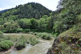
The Middle Fork Coquille River is a tributary, about 40 miles (64 km) long, of the South Fork Coquille River in the U.S. state of Oregon. It begins near Camas Mountain in Douglas County in the Southern Oregon Coast Range. It flows generally south, bypassing the community of Camas Valley while passing through the valley of the same name, then curves west and north to Remote in Coos County. The Middle Fork then flows generally west, passes by the small community of Bridge, and meets the South Fork near Myrtle Point. The confluence with the South Fork is 41 miles (66 km) by water to where the main stem of the Coquille River enters the Pacific Ocean at Bandon.


