
Charleston is an unincorporated community in Coos County, Oregon, United States. Charleston is the least populated community in Oregon's Bay Area and is Home to a large commercial fishing fleet, it is adjacent to the ocean entrance to Coos Bay. Charleston is the site of the Oregon Institute of Marine Biology and the United States Coast Guard Charleston Lifeboat Station.
Fairview is an unincorporated community in Coos County, Oregon, United States. Fairview is along the North Fork Coquille River about 6 miles (10 km) northeast of Coquille.
Broadbent is an unincorporated community in Coos County, Oregon, United States. Broadbent is on Oregon Route 542 south of Myrtle Point along the South Fork Coquille River. Broadbent has a post office with ZIP code 97414.
Norway is an unincorporated community in Coos County, Oregon, United States, located between Coquille and Myrtle Point on Oregon Route 42, near the Coquille River.
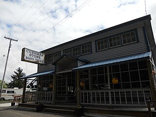
Cushman is an unincorporated community in Lane County, Oregon, United States. It is located on the north bank of the Siuslaw River on Oregon Route 126, between Tiernan and Florence.
Leneve is an unincorporated community in Coos County, Oregon, United States. It lies along North Bank Road off Oregon Route 42 northeast of Coquille. Beaver Slough enters the Coquille River at Leneve.
Libby, previously known as Easport, is an unincorporated community on Coalbank Slough in Coos County, Oregon, United States. It was named for a Native American woman. Its post office was established on June 11, 1890, and operated for just two years. Enoch Gore was postmaster.
Linslaw is an unincorporated community in Lane County, Oregon, United States. It is located about eight miles west of Walton on Oregon Route 126 next to the Siuslaw River.

Hauser is an unincorporated community in Coos County, Oregon, United States. It is along U.S. Route 101, 7 miles (11 km) south of Lakeside and 6 miles (10 km) north of North Bend. Hauser is on the edge of the Oregon Dunes National Recreation Area near North Slough, a tributary of Coos Bay once known as the North Inlet of Coos Bay. It is a station on the Central Oregon and Pacific Railroad.
Prosper is an unincorporated community in Coos County, Oregon, United States. It is about 3 miles (5 km) northwest of Bandon next to the Coquille River. There is no longer a town at the site.
Tiernan is an unincorporated community in Lane County, Oregon, United States. It is about five miles west of Mapleton on Oregon Route 126 near the Siuslaw River and within the Siuslaw National Forest.
Gravelford is an unincorporated community in Coos County, Oregon, United States. It is about 8 miles (13 km) northeast of Myrtle Point, at the confluence of the North Fork Coquille River and the East Fork Coquille River.
Gaylord is an unincorporated community in Coos County, Oregon, United States. It is about 12 miles (19 km) south of Myrtle Point on Oregon Route 542, near the South Fork Coquille River.

Sitkum is an unincorporated community in Coos County, Oregon, United States. It is about 27 miles north of Remote in the Southern Oregon Coast Range near the East Fork Coquille River. Sitkum is served by the Myrtle Point post office.
Dora is an unincorporated community in Coos County, Oregon, United States. It is about 19 miles (31 km) east of Coquille near the East Fork Coquille River on the former route of the Coos Bay Wagon Road. It is in the Southern Oregon Coast Range.
Cooston is an unincorporated community in Coos County, Oregon, United States. It is located on the east shore of Coos Bay across from North Bend, about eight miles from the city of Coos Bay.
Dellwood is an unincorporated community in Coos County, Oregon, United States. It is about 12 miles (19 km) east of Coos Bay, east of Oregon Route 241 on the South Fork Coos River.

The Coos Bay Wagon Road or Coos Bay Military Wagon Road was a pioneer road in the U.S. state of Oregon that connected Douglas County to Coos Bay starting in 1872. Travelers on the road could start in either Tenmile or Lookingglass near Roseburg. The route passed through Reston, Sitkum, Dora, McKinley, and Fairview, ending in Sumner south of Coos Bay. Eventually the road was continued to Eastside, now a neighborhood of Coos Bay. The road follows the East Fork Coquille River from near the Coos/Douglas county line to Dora.
Beaver Hill is an unincorporated community in Coos County, Oregon, United States. It is about 12 miles (19 km) south of the city of Coos Bay, east of U.S. Route 101 and west of Oregon Route 42.
Tenmile is an unincorporated community in Coos County, Oregon, United States. It is about 8 miles (13 km) south of Winchester Bay and one mile west of Lakeside, on U.S. Route 101 next to Tenmile Creek and the Oregon Dunes. Tenmile Lake was named for Tenmile Creek, which was said to be ten miles south of Winchester Bay.


