Oahe Acres, South Dakota | |
|---|---|
 Oahe Acres  Oahe Acres | |
| Coordinates: 44°27′53″N100°20′42″W / 44.46472°N 100.34500°W | |
| Country | United States |
| State | South Dakota |
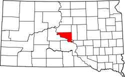
| County | Hughes |
| Area | |
• Total | 1.32 sq mi (3.42 km2) |
| • Land | 1.32 sq mi (3.42 km2) |
| • Water | 0 sq mi (0.00 km2) |
| Elevation | 1,729 ft (527 m) |
| Population | |
• Total | 503 |
| • Density | 380.8/sq mi (147.03/km2) |
| Time zone | UTC-6 (Central (CST)) |
| • Summer (DST) | UTC-5 (CDT) |
| ZIP Code | 57501 (Pierre) |
| Area code | 605 |
| FIPS code | 46-46240 |
| GNIS feature ID | 2813032 [2] |
Oahe Acres is an unincorporated community and census-designated place (CDP) in Hughes County, South Dakota, United States. It was first listed as a CDP prior to the 2020 census. [2] The population of the CDP was 503 at the 2020 census. [4]
It is in the northwest part of the county, 7 miles (11 km) north of Pierre, the state capital, and 2 miles (3 km) east of Oahe Dam on the Missouri River.