
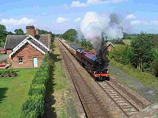
Disley is a village and civil parish in Cheshire, England. It is located on the edge of the Peak District in the Goyt valley, south of Stockport and close to the county boundary with Derbyshire at New Mills. The population at the 2011 Census was 4,294. To the north, the River Goyt and the Peak Forest Canal, which opened in 1800, pass along the edge of the village. Today, it is a dormitory village retaining a semi-rural character.

Bakewell is a market town and civil parish in the Derbyshire Dales district of Derbyshire, England, known for Bakewell pudding. It lies on the River Wye, 13 miles (21 km) south-west of Sheffield. At the 2011 census, the population of the civil parish was 3,949. It was estimated at 3,695 in 2019. The town is close to the tourist attractions of Chatsworth House and Haddon Hall.

Wirksworth is a market town in the Derbyshire Dales district of Derbyshire, England. Its population of 4,904 in the 2011 census was estimated at 5,180 in 2019. Wirksworth contains the source of the River Ecclesbourne. The town was granted a market charter by Edward I in 1306 and still holds a market on Tuesdays in the Memorial Gardens. The parish church of St Mary's is thought to date from 653. The town developed as a centre for lead mining and stone quarrying. Many lead mines were owned by the Gell family of nearby Hopton Hall.

Dronfield is a town in North East Derbyshire, England, which includes Dronfield Woodhouse and Coal Aston. It lies in the valley of the River Drone between Chesterfield and Sheffield. The Peak District National Park is three miles (4.8 km) to the west. The name comes from the Old English Dranfleld, probably meaning an open land infested with drone bees.

Youlgreave or Youlgravelisten (help·info) is a village and civil parish in the Peak District of Derbyshire, England, on the River Bradford 2+1⁄2 miles (4.0 km) south of Bakewell. The name possibly derives from "yellow grove", the ore mined locally being yellow in colour. The population in 1991 was 1,256; it is one of the largest villages in the Peak District National Park.

Tissington is a village in the Derbyshire Dales district of Derbyshire, England. The appropriate civil parish is called Tissington and Lea Hall. The population of this parish at the 2011 census was 159. It is part of the estate of Tissington Hall, owned by the FitzHerbert family since 1465. It is a popular tourist attraction, particularly during its well dressing week. It also gives its name to the Tissington Trail, a 13-mile (21 km) walk and cycle path which passes nearby. The Limestone Way, another long-distance path and bridleway, passes through the village itself.

Alrewas is a village and civil parish in the Lichfield District of Staffordshire, England.

Westhoughton is a town and civil parish in the Metropolitan Borough of Bolton, Greater Manchester, England, 4 miles (6 km) southwest of Bolton, 5 miles (8 km) east of Wigan and 13 miles (21 km) northwest of Manchester.

Ashford-in-the-Water is a village and civil parish in the Derbyshire Peak District, England. The village is on the River Wye, 2 miles (3 km) north-west of Bakewell. It is known for the quarrying of Ashford Black Marble, and for the maidens' garlands made to mark the deaths of virgins in the village until 1801. Some of these are preserved in the parish church. The civil parish population taken at the 2011 Census was 559.

Marple Bridge is a district of Marple in the Metropolitan Borough of Stockport, Greater Manchester, England, on the River Goyt, which runs through the centre of the village.

Bilsby is a village and civil parish in the East Lindsey district of Lincolnshire, England. It lies on the main A1111 road between Alford and Sutton-on-Sea, 1 mile (1.6 km) east of Alford. Thurlby and Asserby are hamlets within Bilsby parish. The censuses showed a parish population of 538 in 2001 and 487 in 2011, with an estimate of 489 in 2019.
Cumwhinton is a small village in Cumbria, England. It is around one mile away from both Scotby and Wetheral, and four miles from Carlisle. The village lies in Wetheral civil parish.

Tissington Hall is an early 17th-century Jacobean mansion house in Tissington, near Ashbourne, Derbyshire. It is a Grade II* listed building.

St Mary’s Church, Tissington is a Grade II* listed parish church in the Church of England in Tissington, Derbyshire.
Highlow is a civil parish within the Derbyshire Dales district, in the county of Derbyshire, England. Largely rural, Highlow's population is reported with the population of neighbouring parishes for a total of 585 residents in 2011. It is 140 miles (230 km) north-west of London, 28 miles (45 km) north-west of the county city of Derby, and 7+1⁄2 miles (12.1 km) north of the nearest market town of Bakewell. Highlow is wholly within the Peak District national park, and shares a border with the parishes of Abney and Abney Grange, Eyam, Foolow, Grindleford, Hathersage as well as Offerton. There are nine listed buildings in Highlow.
Catton is a civil parish in the South Derbyshire district of Derbyshire, England. The parish contains five listed buildings that are recorded in the National Heritage List for England. Of these, one is listed at Grade II*, the middle of the three grades, and the others are at Grade II, the lowest grade. The most important building in the parish is Catton Hall, which is listed at Grade II*. All the other listed buildings are associated with the hall, and consist of the kitchen garden walls, two stable ranges and a chapel.
Offerton is a civil parish in the Derbyshire Dales district of Derbyshire, England. The parish contains six listed buildings that are recorded in the National Heritage List for England. Of these, one is listed at Grade II*, the middle of the three grades, and the others are at Grade II, the lowest grade. The parish is almost entirely rural, and the listed buildings consist of houses, farmhouses and farm buildings.
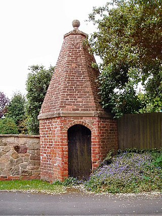
The lock-up in Smisby, Derbyshire, England, is a village lock-up dating from the late 18th century. Such lock-ups were fairly common in England at that time and were used to hold miscreants, often drunkards, or other low-level offenders awaiting transportation to the local assizes, for short periods of time. The Smisby lock-up is built of brick and is a Grade II* listed building.
Yeaveley is a civil parish in the Derbyshire Dales district of Derbyshire, England. The parish contains nine listed buildings that are recorded in the National Heritage List for England. Of these, one is listed at Grade I, the highest of the three grades, one is at Grade II*, the middle grade, and the others are at Grade II, the lowest grade. The parish contains the village of Yeaveley and the surrounding countryside. The oldest listed building in the parish consists of the remains of a preceptory of the Knights Hospitaller. The other listed buildings are houses and associated structures, farmhouses and farm buildings, and a church.


