
The Wurundjeri are an Aboriginal Australian nation of the Woiwurrung language group, in the Kulin alliance. They occupied the Birrarung Valley before British colonisation of the area, around the present location of Melbourne.

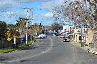
Stawell, is an Australian town in the Wimmera region of Victoria 237 kilometres (147 mi) west-north-west of the state capital, Melbourne. Located within the Shire of Northern Grampians local government area, it is a seat of local government for the shire and its main administrative centre. At the 2016 census, Stawell had a population of 6,032.

Officer is suburb of Melbourne, Victoria, Australia, 48 km south-east of Melbourne's Central Business District, located within the Shire of Cardinia local government area. Officer recorded a population of 7,133 at the 2016 Census. Officer serves as the Council seat of the shire.

Pakenham is a satellite suburb of Melbourne on the edge of the West Gippsland region of Victoria, Australia, 53 km (33 mi) south-east of Melbourne's Central Business District, located within the Shire of Cardinia local government area. Pakenham recorded a population of 46,421 at the 2016 Census.

Pakenham Upper is a rural locality situated south-east of Melbourne City, located in the Shire of Cardinia local government area north of Pakenham.
Pakenham South is a suburb and rural locality situated south-east of Melbourne City, located in the Shire of Cardinia local government area south of Pakenham.

Springvale is a suburb in Melbourne, Victoria, Australia, 22 km (14 mi) southeast of the Melbourne central business district. Its local government area is the City of Greater Dandenong. At the 2016 census, Springvale had a population of 21,714.

Greensborough is a suburb of Melbourne, Victoria, Australia, 17 km (11 mi) north-east from Melbourne's Central Business District. Its local government areas are the City of Banyule and the Shire of Nillumbik. At the 2016 Census, Greensborough had a population of 20,821.
Essendon, is a suburb of Melbourne, Victoria, Australia, 8 km (5.0 mi) north-west of Melbourne's central business district. Its local government area is the City of Moonee Valley. At the 2016 census, Essendon had a population of 20,596.

Oakleigh is a suburb of Melbourne, Victoria, Australia 14 km south-east of Melbourne's central business district. Its local government area is the City of Monash. At the 2016 Census, Oakleigh had a population of 7,893.

Ararat is a city in south-west Victoria, Australia, about 198 kilometres (120 mi) west of Melbourne, on the Western Highway on the eastern slopes of the Ararat Hills and Cemetery Creek valley between Victoria's Western District and the Wimmera. Its urban population according to 2016 census is 8,297 and services the region of 11,752 residents across the Rural City's boundaries. It is also the home of the 2018/19 GMGA Golf Championship Final.
Bacchus Marsh is an urban centre and suburban locality in Victoria, Australia located approximately 50 kilometres (30 mi) north west of the state capital Melbourne and 14 kilometres (9 mi) west of Melton at a near equidistance to the major cities of Melbourne, Ballarat and Geelong. The population of the Bacchus Marsh urban area was 22,223 at June 2018. Bacchus Marsh is the largest urban area in the local government area of Shire of Moorabool.

Kulin is a town in the eastern Wheatbelt region of Western Australia, approximately 280 km from Perth. It is the main town in the Shire of Kulin.

Kilgariff is a suburb of Alice Springs located in the Northern Territory of Australia about 1,290 kilometres (800 mi) south of the territory capital of Darwin and about 7 kilometres (4.3 mi) south of the municipal seat in the Alice Springs central business district.
Mount Atkinson is a suburb of greater metropolitan Melbourne located 25km northwest of Melbourne City (CBD) in the state of Victoria, Australia. Its local government area is the City of Melton.
Tarneit Plains is a suburb in the outer west of Melbourne, Victoria, Australia. Its local government area is the City of Melton.

Angus is a suburb of Sydney, in the state of New South Wales, Australia. Angus is located north-west of Sydney City in the local government area of Blacktown.
Richards is a suburb of Sydney, in the state of New South Wales, Australia. Richards is located north-west of Sydney City in the local government area of Blacktown.
Melonba is a suburb of Sydney, in the state of New South Wales, Australia. Melonba is located north-west of Sydney City in the local government area of Blacktown.
Pakenham East is a suburb of the greater Melbourne metropolitan area situated south-east of Melbourne City. Pakenham East is located in the Shire of Cardinia local government area.
