
The Shire of Yarra Ranges, also known as Yarra Ranges Council, is a local government area in Victoria, Australia, located in the outer eastern and northeastern suburbs of Melbourne extending into the Yarra Valley and Dandenong Ranges. It has an area of 2,468 square kilometres (953 sq mi), of which 3% is classified as urban. In June 2018, it had a population of 158,173.

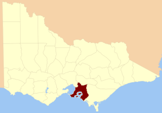
The Shire of Cardinia is a local government area in Victoria, Australia, in the south-east of Melbourne between Western Port and the Yarra Ranges on the outskirts of Melbourne. It has an area of 1,283 square kilometres, and had a population of 107,120 in June 2018.

Clyde North is a suburb in Melbourne, Victoria, Australia, 46 km south-east of Melbourne's central business district. Its local government area is the City of Casey. At the 2016 census, Clyde North had a population of 8,157.

Tooradin is a town in Victoria, Australia, 57 km south east from the central business district of Melbourne. Its local government area is the City of Casey. At the 2016 census, Tooradin had a population of 1,568.

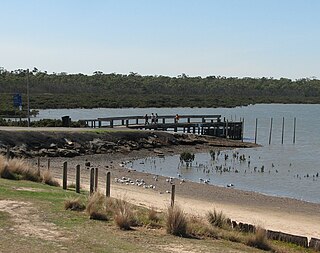
Warneet is a town in Victoria, Australia, 54 km (34 mi) south-east of Melbourne's central business district at the head of the large bay of Western Port. Its local government area is the City of Casey. At the 2016 census, Warneet had a population of 536.

Devon Meadows is a town in Victoria, Australia, 50 km south-east of Melbourne's central business district. Its local government area is the City of Casey. At the 2016 census, Devon Meadows had a population of 1,548.
Blind Bight is a town in Victoria, Australia, 55 km south-east from Melbourne's central business district on the large bay of Western Port. Its local government area is the City of Casey. At the 2016 census, Blind Bight had a population of 1,251.
Koo Wee Rup was a railway station on the South Gippsland line in South Gippsland, Victoria, Australia. The station operated until the closure of the line between Cranbourne Station and Leongatha Station in July 1993. The station remains partly intact with the platform and goods shed intact, however the track one kilometre on each side of the station platform has been dismantled, and replaced by a concrete pathway for bicycles and recreational use. Koo Wee Rup was also the junction of the branch line to Strzelecki. The establishment of the pathway has effectively removed any likelihood that the railway will be rehabilitated. It can also be seen as being the start of a rail trail on the railway reserve, stretching back to Cranbourne, which will block future rail transport options for people in Cranbourne East, Clyde, and surrounding areas.
Nyora is a railway station on the former South Gippsland line in South Gippsland, Victoria, Australia.
The County of Mornington is one of the 37 counties of Victoria which are part of the cadastral divisions of Australia, used for land titles. It is located to the south-east of Melbourne, including the Mornington Peninsula, French Island and Phillip Island. The county was proclaimed in 1849.

The Shire of Pakenham was a local government area located about 60 kilometres (37 mi) southeast of Melbourne, the state capital of Victoria, Australia. The shire covered an area of 874 square kilometres (337.5 sq mi), and existed from 1862 until 1994.
The City of Cranbourne was a local government area about 45 kilometres (28 mi) southeast of Melbourne, the state capital of Victoria, Australia. The city covered an area of 755 square kilometres (291.5 sq mi), and existed from 1860 until 1994. It was notable for being the last local government area to be declared a city prior to the large-scale amalgamations of 1994 – its former designation was the Shire of Cranbourne.
Caldermeade is a bounded rural locality in Victoria, Australia, 71 kilometres (44 mi) south-east of Melbourne's Central Business District, located within the Shire of Cardinia local government area. Caldermeade recorded a population of 181 at the 2021 census.
Catani is a bounded rural locality in Victoria, Australia, 72 kilometres (45 mi) south-east of Melbourne's Central Business District, located within the Shire of Cardinia local government area. Catani recorded a population of 297 at the 2016 census.
Cora Lynn is a bounded rural locality in Victoria, Australia, 68 km south-east of Melbourne's Central Business District, located within the Shire of Cardinia local government area. Cora Lynn recorded a population of 220 at the 2021 census.
Dalmore is a bounded rural locality in Victoria, Australia, 58 km south-east of Melbourne's Central Business District, located within the Shire of Cardinia local government area. Dalmore recorded a population of 142 at the 2021 census.
Koo Wee Rup North is a bounded rural locality in Victoria, Australia, 62 kilometres (39 mi) south-east of Melbourne's Central Business District, located within the Shire of Cardinia local government area. Koo Wee Rup North recorded a population of 44 at the 2016 census.
Vervale is a bounded rural locality in Victoria, Australia, 71 kilometres (44 mi) south-east of Melbourne's Central Business District, located within the Shire of Cardinia local government area. Vervale recorded a population of 39 at the 2016 census.

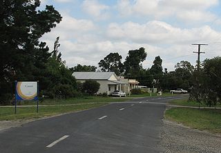
Koo Wee Rup is a town in Victoria, Australia, 63 km south-east of Melbourne's Central Business District, located within the Shire of Cardinia local government area. Koo Wee Rup recorded a population of 3,579 at the 2016 census.

The Koo-Wee-Rup Swamp was a large freshwater swamp located to the south east of Melbourne, Victoria. It drained an area of West Gippsland, with several waterways including Cardinia Creek and the Bunyip River.

