Ojibwa Island

Last updated
Ojibwa Island
Beaver Island satellite photo.jpg
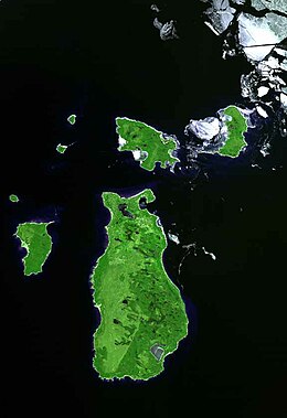
Ojibwa Island is the small island in the north west corner.
USA Michigan location map.svg
Red pog.svg
Ojibwa Island
Usa edcp location map.svg
Red pog.svg
Ojibwa Island
Geography
Location Lake Michigan
Coordinates 45°50′13″N85°35′12″W / 45.8369401°N 85.5867590°W / 45.8369401; -85.5867590
Area75 acres (30 ha)
Highest elevation594 ft (181.1 m)
Administration
State Michigan
County Charlevoix County
Township St. James Township

Ojibwa Island (formerly known as Squaw Island [1] ) is an island in Lake Michigan and is part of the Beaver Island archipelago. [2] The island is about 75 acres in size, and is privately owned. Ojibwa Island is located a little under two miles north east of Whiskey Island, and a little over three miles west of Garden Island. [3]

The historic Squaw Island Light is located on the north point of the Island.

Climate

Ojibwa Island
Climate chart (explanation)
J
F
M
A
M
J
J
A
S
O
N
D
 
 
72
 
 
−4
−10
 
 
55
 
 
−10
−15
 
 
48
 
 
−3
−8
 
 
114
 
 
2
−3
 
 
84
 
 
7
5
 
 
79
 
 
11
8
 
 
107
 
 
17
14
 
 
96
 
 
16
12
 
 
103
 
 
16
13
 
 
127
 
 
9
6
 
 
83
 
 
6
5
 
 
66
 
 
1
−5
Average max. and min. temperatures in °C
Precipitation totals in mm
Source: [4]
Imperial conversion
JFMAMJJASOND
 
 
2.8
 
 
25
14
 
 
2.2
 
 
14
5
 
 
1.9
 
 
27
18
 
 
4.5
 
 
36
27
 
 
3.3
 
 
45
41
 
 
3.1
 
 
52
46
 
 
4.2
 
 
63
57
 
 
3.8
 
 
61
54
 
 
4.1
 
 
61
55
 
 
5
 
 
48
43
 
 
3.3
 
 
43
41
 
 
2.6
 
 
34
23
Average max. and min. temperatures in °F
Precipitation totals in inches

Related Research Articles

<span class="mw-page-title-main">Lake Michigan</span> One of the Great Lakes of North America

Lake Michigan is one of the five Great Lakes of North America. It is the second-largest of the Great Lakes by volume and the third-largest by surface area, after Lake Superior and Lake Huron. To the east, its basin is conjoined with that of Lake Huron through the 3+12-mile (5.6-kilometer) wide, 295-foot deep Straits of Mackinac, giving it the same surface elevation as its easterly counterpart; the two are geologically a single lake.

<span class="mw-page-title-main">Marquette County, Michigan</span> County in Michigan, United States

Marquette County is a county located in the Upper Peninsula of the U.S. state of Michigan. As of the 2020 census, the population was 66,017. The county seat is Marquette. The county is named for Father Marquette, a Jesuit missionary. It was set off in 1843 and organized in 1851. Marquette County is the largest county in land area in Michigan, and the most populous county in the Upper Peninsula.

<span class="mw-page-title-main">Fairbanks Township, Michigan</span> Civil township in Michigan, United States

Fairbanks Township is a civil township of Delta County in the U.S. state of Michigan. As of the 2010 census, the township population was 281, down from 321 at the 2000 census.

<span class="mw-page-title-main">Garden Township, Michigan</span> Civil township in Michigan, United States

Garden Township is a civil township of Delta County in the U.S. state of Michigan. As of the 2010 census, the township had a total population of 750, down from 817 at the 2000 census. In 2012, it became home to the first wind farm in the Upper Peninsula, the 28 MW Garden Wind Farm.

<span class="mw-page-title-main">Wallops Flight Facility</span> American spaceport in Virginia

Wallops Flight Facility (WFF) is a rocket launch site on Wallops Island on the Eastern Shore of Virginia, United States, just east of the Delmarva Peninsula and approximately 100 miles (160 km) north-northeast of Norfolk. The facility is operated by the Goddard Space Flight Center in Greenbelt, Maryland, and primarily serves to support science and exploration missions for NASA and other Federal agencies. WFF includes an extensively instrumented range to support launches of more than a dozen types of sounding rockets; small expendable suborbital and orbital rockets; high-altitude balloon flights carrying scientific instruments for atmospheric and astronomical research; and, using its Research Airport, flight tests of aeronautical research aircraft, including unmanned aerial vehicles.

<span class="mw-page-title-main">Squaw Island Light</span> Lighthouse in Michigan, United States

Squaw Island Light is a privately owned lighthouse located on Ojibwa Island in Lake Michigan, about six miles (10 km) north of Beaver Island. The island is part of St. James Township in Charlevoix County of the U.S. state of Michigan. There are 0.30406 square kilometres of land on the island. Squaw Island and the lighthouse are privately owned and views of the lighthouse from the water are limited due to vegetation.

<span class="mw-page-title-main">Apostle Islands</span> Lake Superior archipelago in northern Wisconsin

The Apostle Islands are a group of 22 islands in Lake Superior, off the Bayfield Peninsula in northern Wisconsin. The majority of the islands are located in Ashland County—only Sand, York, Eagle, and Raspberry Islands are located in Bayfield County. All the islands except for Madeline Island are part of the Apostle Islands National Lakeshore. The islands in Ashland County are all in the Town of La Pointe, except for Long Island, which is in the Town of Sanborn, while those in Bayfield County are in the Towns of Russell and Bayfield.

<span class="mw-page-title-main">Granite Island (Michigan)</span>

Granite Island is a 2.5-acre (1.0 ha) island in Lake Superior located about 12 miles (19 km) northwest of Marquette in the Upper Peninsula of the U.S. state of Michigan. Built upon it is the Granite Island Lighthouse, also known as Granite Island Light Station, "one of the oldest surviving lighthouses on Lake Superior". It is part of Marquette Township, in Marquette County.

<span class="mw-page-title-main">Washington Island (Wisconsin)</span> Island in Lake Michigan

Washington Island is an island of the state of Wisconsin situated in Lake Michigan. Lying about 7 miles (11 km) northeast of the tip of the Door Peninsula, it is part of Door County, Wisconsin. The island has a year-round population of 708 people according to the 2010 census. It has a land area of 60.9 km2 and comprises over 92 percent of the land area of the town of Washington, as well as all of its population. The unincorporated community of Detroit Harbor is situated on the island. It is the largest in a group of islands that includes Plum, Detroit, Hog, Pilot, Fish, and Rock Islands. These islands form the Town of Washington. Detroit Harbor bay is on the south side of the island. A large part of Washington Island's economy is based on tourism.

<span class="mw-page-title-main">Plum Island (Wisconsin)</span>

Plum Island is an island in Lake Michigan in the southern part of the town of Washington in Door County, off the tip of the Door Peninsula in the U.S. state of Wisconsin. The uninhabited island has a land area of 1.179 square kilometres (0.455 sq mi) or 117.87 hectares. Carp Lake is located on the northwestern side. During years when Lake Michigan's water levels are high, it is a lagoon of Lake Michigan, but it gets cut off as a separate lake during low water years.

<span class="mw-page-title-main">Zeba, Michigan</span> Census-designated place & unincorporated community in Michigan, United States

Zeba is an unincorporated community and census-designated place (CDP) in Baraga County in the U.S. state of Michigan. The CDP had a population of 397 at the 2020 census. The community is located near the southern end of the Keweenaw Bay just north of the village of L'Anse within L'Anse Township.

<span class="mw-page-title-main">Chippewa Valley Schools</span> School district in Michigan

Chippewa Valley Schools is a school district with its headquarters located in Clinton Township, Macomb County, Michigan. The district encompasses over 27 square miles, partially serving students of the Clinton Township and Macomb Township along with other nearby districts. It served 16,226 students during the 2016-2017 school year, making it the 6th-largest school district by enrollment in the state. The school district was formed in 1959 through the consolidation of six existing school districts.

<span class="mw-page-title-main">Grand Rapids Medical Mile</span> Medical corridor of Grand Rapids in Michigan, United States

Grand Rapids Medical Mile is a designated area within the city of Grand Rapids, Michigan. It began with medical-related development in the Hillside District of Grand Rapids, Michigan, bordering both sides of Michigan Street. More than a decade later it encompasses an area five times larger, expanding east further down Michigan St.and north across Interstate 196. It has also been referred to as Grand Rapids Medical Corridor, Michigan Street Medical Corridor, Health Hill, Medical Hill, and Pill Hill, among other names.

<span class="mw-page-title-main">Christina Koch</span> American astronaut (born 1979)

Christina Hammock Koch is an American engineer and NASA astronaut of the class of 2013. She received Bachelor of Science degrees in electrical engineering and physics and a Master of Science in electrical engineering at North Carolina State University. She also did advanced study while working at the Goddard Space Flight Center. Just before becoming an astronaut, she served at the National Oceanic and Atmospheric Administration as station chief for American Samoa.

<span class="mw-page-title-main">2017–18 Michigan State Spartans men's basketball team</span> American college basketball season

The 2017–18 Michigan State Spartans men's basketball team represented Michigan State University in the 2017–18 NCAA Division I men's basketball season. The Spartans, led by 23rd-year head coach Tom Izzo, played their home games at Breslin Center in East Lansing, Michigan as members of the Big Ten Conference.

<span class="mw-page-title-main">Power Island</span>

Power Island is an island in Lake Michigan in the U.S. state of Michigan. Part of Grand Traverse County, Power Island is located in the west arm of Grand Traverse Bay, between the Leelanau Peninsula (west) and Old Mission Peninsula (east). The island was once owned and operated by Henry Ford.

<span class="mw-page-title-main">Trout Island (Michigan)</span>

Trout Island is an island in Lake Michigan and is part of the Beaver Island archipelago. The island is 80 acres in size, and is privately owned. There is an airstrip on the island that extends across the whole island to both shorelines. Trout Island is a little under two miles from High Island, and a little over six miles from Beaver Island. The island is part of the Beaver Island Archipelago.

<span class="mw-page-title-main">Sister Islands (Wisconsin)</span> Two islands in Lake Michigan, U.S.

The Sister Islands are two islands in Lake Michigan. They are located in the bay of Green Bay, in the town of Liberty Grove, Wisconsin. At one point the islands were connected, but higher water levels have eroded the size of the islands. Combined, the area of the islands sits at 6 acres (2.4 ha).

<span class="mw-page-title-main">Temperance Island</span> People who had seen him were able to give a description

Temperance Island is an island off of Waugoshance Point, in Lake Michigan. It is located in Bliss Township of Emmet County, Michigan. Temperance and nearby Waugoshance Island are part of the Wilderness State Park. The Big Cut Canal separates the islands from Waugoshance Point. Together the islands form the northern boundary for sturgeon bay.

Bellow Island, also known as Gull Island, is an island in the Grand Traverse Bay, a bay of Lake Michigan, located in Leelanau Township, Leelanau County, Michigan.

References

  1. Burr|aburr@mlive.com, Alyssa (2022-09-14). "Slur for Native American women removed from over 30 Michigan landmarks". mlive. Retrieved 2023-01-28.
  2. "Report For Squaw Island". USGNIS. Retrieved 16 April 2018.
  3. "Garden and Hog Islands, Michigan". NASA Earth Observatory. Retrieved 16 April 2018.
  4. "NASA Earth Observations Data Set Index". NASA. Retrieved 30 January 2016.