Okatie, South Carolina

Last updated
Okatie, South Carolina
USA South Carolina location map.svg
Red pog.svg
Okatie
Usa edcp location map.svg
Red pog.svg
Okatie
Coordinates: 32°17′51″N80°57′04″W / 32.29750°N 80.95111°W / 32.29750; -80.95111
Country United States
State South Carolina
Counties Beaufort, Jasper
Elevation
13 ft (4 m)
Population
 (2010)
  Total12,570
ZIP code
29909
Area code(s) 843, 854

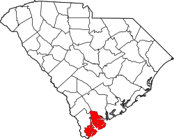
Okatie (pronounced "OH-kuh-tee") is an unincorporated suburban community west of Hilton Head Island, located in Beaufort and Jasper counties, in the Lowcountry of South Carolina. Okatie takes its name from the nearby Okatee River, an estuary of the Port Royal Sound. The headquarters of the Beaufort-Jasper Water and Sewer Authority are located in Okatie, as are the Beaufort-Jasper Academy for Career Excellence and John Paul II Catholic High School.

Okatie is an unincorporated area stretching from south central Jasper County to western Beaufort County, between I-95 and SC 462. [1] It was designated a voting precinct on March 1, 1916, by the General Assembly of the State of South Carolina. [2] Portions of Okatie have been annexed by Bluffton, Hardeeville and Port Royal. South Carolina Highway 170 (also known as Okatie Highway) is generally considered to be the main route through Okatie.

Okatie has experienced predominantly low-density residential development since the 1990s, including Sun City Hilton Head, Riverbend, and Oldfield. Additional commercial and low intensity industrial development have also occurred, primarily in the Jasper County sections of Okatie. This development pattern has resulted in concerns over water quality and loss of forest habitat for wildlife. Previous efforts to incorporate the community have been unsuccessful, due in part to conflicting opinions on the future of growth and development in the area.[ citation needed ]

Related Research Articles

<span class="mw-page-title-main">Jasper County, South Carolina</span> County in South Carolina, United States

Jasper County is the southernmost county in the U.S. state of South Carolina. As of the 2020 census, the population was 28,791. Its county seat is Ridgeland and its largest city is Hardeeville. The county was formed in 1912 from portions of Hampton County and Beaufort County.

<span class="mw-page-title-main">Beaufort County, South Carolina</span> County in South Carolina, United States

Beaufort County is a county in the U.S. state of South Carolina. As of the 2020 census, its population was 187,117. Its county seat is Beaufort and its largest town is Hilton Head Island.

<span class="mw-page-title-main">Beaufort, South Carolina</span> City in South Carolina, United States

Beaufort is a city in and the county seat of Beaufort County, South Carolina, United States. Chartered in 1711, it is the second-oldest city in South Carolina, behind Charleston, which was established in 1670. A city rich in history, culture, southern hospitality, and a seaside charm, Beaufort is affectionally known as the "Queen of the Carolina Sea Islands". The city's population was 13,607 at the 2020 census. It is part of the Hilton Head Island–Bluffton metropolitan area.

<span class="mw-page-title-main">Bluffton, South Carolina</span> Town in South Carolina, United States

Bluffton is a town in southern Beaufort County, South Carolina, United States. The population as of the 2020 census was 27,716, an increase of over 120% since 2010, making it one of the fastest growing municipalities in South Carolina. Bluffton is the fifth largest municipality in South Carolina by land area. It is primarily located around U.S. Route 278, between Hilton Head Island and Interstate 95. The Lowcountry town's original one square mile area, now known as Old Town, is situated on a bluff along the May River. The town is a primary town within the Hilton Head Island–Bluffton Metropolitan Area.

<span class="mw-page-title-main">Port Royal, South Carolina</span> Town in South Carolina, United States

Port Royal is a town on Port Royal Island in Beaufort County, South Carolina, United States. The population was 14,220 at the 2020 census. It is part of the Hilton Head Island–Bluffton metropolitan area. Port Royal is home to Marine Corps Recruit Depot Parris Island and United States Naval Hospital Beaufort.

<span class="mw-page-title-main">Hardeeville, South Carolina</span> City in South Carolina, United States

Hardeeville is a city in Jasper and Beaufort counties in the U.S. state of South Carolina. The population was 7,473 as of the 2020 census, an increase of over 150% since 2010. Hardeeville is included within the Hilton Head Island–Bluffton metropolitan area.

<span class="mw-page-title-main">Saint Helena Island (South Carolina)</span> Island in South Carolina, United States

St. Helena Island is a Sea Island in Beaufort County, South Carolina, United States. The island is connected to Beaufort by U.S. Highway 21. The island has a land area of about 64 sq mi (170 km2) and a population of 8,763 as of the 2010 census. It is included as part of the Hilton Head Island-Beaufort Micropolitan Area. The island is renowned for its rural Lowcountry character and being a major center of African-American Gullah culture and language. It is considered to be the geographic influence behind the children's television program Gullah Gullah Island.

<span class="mw-page-title-main">W30CV-D</span> Low-power TV station in Hilton Head Island, South Carolina

W30CV-D, virtual and UHF digital channel 30, branded on-air as WHHI-TV, is a low-powered, Class A independent television station licensed to Hilton Head Island, South Carolina. The station is carried on area cable systems operated by Hargray Channel(s) 8 and 418 and Spectrum channel(s) 3 and 1230. as well as IPTV services DirecTV Stream, Hulu Live, Sling and YouTube TV.

<span class="mw-page-title-main">Area codes 843 and 854</span> Telephone area codes for eastern South Carolina, United States

Area codes 843 and 854 are telephone area codes in the North American Numbering Plan (NANP) for a portion of the U.S. state of South Carolina that comprises roughly the eastern third and the southern tip. The numbering plan area (NPA) includes the Grand Strand, the Lowcountry, the Pee Dee, and the Sandhills. Major cities in the region are Myrtle Beach, Charleston, Beaufort, Hilton Head Island and Florence. Area code 843 was created in 1998 when area code 803 was split, while 854 was added in 2015 to form an all-services overlay.

The Beaufort County School District educates nearly 22,000 students in Beaufort County, South Carolina, United States. It is the second fastest-growing county in the state.

<span class="mw-page-title-main">U.S. Route 278 in South Carolina</span> U.S. highway in South Carolina

U.S. Route 278 (US 278) is a 146.130-mile (235.173 km) east–west United States highway that traverses through the South Carolina Lowcountry, from North Augusta to Hilton Head Island.

<span class="mw-page-title-main">South Carolina Highway 170</span> State highway in South Carolina

South Carolina Highway 170 (SC 170) is a 49.010-mile (78.874 km) state highway, connecting northern Beaufort County with southern portions of Beaufort and Jasper counties. Due to increased population growth in both areas, the majority of the road is four lanes wide, with certain areas retaining the original two-lane configuration.

<span class="mw-page-title-main">South Carolina Highway 46</span> State highway in South Carolina

South Carolina Highway 46 (SC 46) is a 17.330-mile-long (27.890 km) state highway in Jasper and Beaufort counties in the Lowcountry region of South Carolina. It connects the rapidly growing communities of Hardeeville and Bluffton and serves as a parallel route to U.S. Route 278 (US 278).

<span class="mw-page-title-main">Beaufort-Jasper Water and Sewer Authority</span>

The Beaufort-Jasper Water and Sewer Authority is a public water system and non-profit corporation which handles water and wastewater operations for many areas in Beaufort and Jasper counties in the Lowcountry region of South Carolina. The Authority was created under the provisions of Act 784 by the South Carolina General Assembly in 1954 to provide services to Beaufort County. In 1969, its powers were expanded to include wastewater facility construction and services. In 1983, the authority merged with the Jasper County Water and Sewer Authority and thus adopting the BJWSA moniker.

<span class="mw-page-title-main">Sun City Hilton Head</span> Unincorporated community in South Carolina, United States

Del Webb's Sun City Hilton Head is an age-restricted planned community located in the Okatie area of Beaufort and Jasper counties in the Lowcountry region of South Carolina. Although not a separate incorporated community or census-designated place, there are close to 10,000 permanent residents within three major phases of the community, which is clustered around its golf courses and community centers. The community is also renowned for its political activism, with many local, state, and national candidates for political office stopping in Sun City while in the area. Sun City is included within the Hilton Head Island-Bluffton-Beaufort, SC Metropolitan Statistical Area.

Pocotaligo is an unincorporated community located in northeastern Jasper County, South Carolina, United States, close to the border of Beaufort County. The community takes its name from the Pocotaligo River, a small tidal creek that separates Jasper and Beaufort counties. Although historically significant, Pocotaligo today primarily serves as a junction point between U.S. Highway 17, U.S. Highway 17 Alternate and U.S. Highway 21. These roads lead to Interstate 95 at Point South and Yemassee, which have over time eclipsed Pocotaligo in population and importance. Very few people live in the community today.

<span class="mw-page-title-main">Hilton Head Island–Bluffton metropolitan area</span>

The Hilton Head Island–Bluffton metropolitan area, officially the Hilton Head Island–Bluffton, SC Metropolitan Statistical Area as defined by the United States Census Bureau, is a metropolitan statistical area consisting of the two southernmost counties in the Lowcountry region of South Carolina, centered on the resort town of Hilton Head Island. As of the 2020 census, the MSA had a population of 215,908. Prior to March 2013, the region was considered a micropolitan statistical area.

Saint John Paul II Catholic School is a diocesan Roman Catholic school in Okatie, South Carolina, United States. Founded in 2011 and opened in 2013, the school offers grades 6 through 12 for students in Beaufort and Jasper counties. The school is supported through its affiliation with the Diocese of Charleston. It will be the fourth diocesan school to be in operation in South Carolina, joining Bishop England High School in Charleston, Cardinal Newman High School in Columbia and Bishop Baker High School in Myrtle Beach.

<span class="mw-page-title-main">Callawassie Island</span> Island in South Carolina, United States

Callawassie Island is one of hundreds of barrier and sea islands in the southeast corner in the outer coastal plain, making up a portion of Beaufort County, South Carolina.

References

  1. "Okatie, South Carolina". SCIWAY. SCIWAY.net. Retrieved 5 January 2013.
  2. South Carolina (1917). Acts of the General Assembly of South-Carolina. State Printer. p.  198.