Okroglice

Last updated
Okroglice

Okroglice sv. Lovrenc.jpg

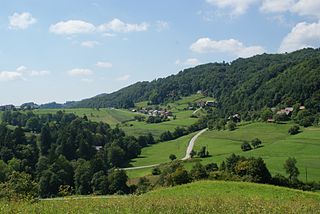
St. Lawrence's Church in Okroglice. Big Kozje Hill in the background.
Slovenia location map.svg
Red pog.svg
Okroglice
Location in Slovenia
Coordinates: 46°4′3.17″N15°15′23.72″E / 46.0675472°N 15.2565889°E / 46.0675472; 15.2565889 Coordinates: 46°4′3.17″N15°15′23.72″E / 46.0675472°N 15.2565889°E / 46.0675472; 15.2565889
Country Flag of Slovenia.svg Slovenia
Traditional region Styria
Statistical region Lower Sava
Municipality Sevnica
Area
  Total 3.66 km2 (1.41 sq mi)
Elevation 417.2 m (1,368.8 ft)
Population (2002)
  Total 85
[1]

Okroglice (pronounced  [ɔˈkɾoːɡlitsɛ] ) is a settlement in the hills northeast of Loka pri Zidanem Mostu in the Municipality of Sevnica in east-central Slovenia. The area is part of the historical region of Styria. The municipality is now included in the Lower Sava Statistical Region. [2]

Loka pri Zidanem Mostu village in Styria, Slovenia

Loka pri Zidanem Mostu is a village on the left bank of the Sava River in the Municipality of Sevnica in central Slovenia. The area is part of the historical region of Styria. The municipality is now included in the Lower Sava Statistical Region.

Municipality of Sevnica Municipality in Slovenia

The Municipality of Sevnica is a municipality along the Sava and the Mirna Rivers in southeastern Slovenia. The seat of the municipality is the town of Sevnica. Today it is part of the Lower Sava Statistical Region. It is the 12th-largest municipality by area in Slovenia.

Slovenia republic in Central Europe

Slovenia, officially the Republic of Slovenia, is a sovereign state located in southern Central Europe at a crossroads of important European cultural and trade routes. It is bordered by Italy to the west, Austria to the north, Hungary to the northeast, Croatia to the southeast, and the Adriatic Sea to the southwest. It covers 20,273 square kilometers (7,827 sq mi) and has a population of 2.07 million. One of the successor states of the former Yugoslavia, Slovenia is a parliamentary republic and a member of the United Nations, of the European Union, and of NATO. The capital and largest city is Ljubljana.

The local church is dedicated to Saint Lawrence and belongs to the Parish of Razbor. It dates to the early 18th century. [3]

Church (building) building constructed for Christian worship

A church building or church house, often simply called a church, is a building used for Christian religious activities, particularly for Christian worship services. The term is often used by Christians to refer to the physical buildings where they worship, but it is sometimes used to refer to buildings of other religions. In traditional Christian architecture, the church is often arranged in the shape of a Christian cross. When viewed from plan view the longest part of a cross is represented by the aisle and the junction of the cross is located at the altar area.

Related Research Articles

Ševnica Place in Lower Carniola, Slovenia

Ševnica is a small village west of Mirna in the Municipality of Mirna in southeastern Slovenia. The area is part of the traditional region of Lower Carniola. The municipality is now included in the Southeast Slovenia Statistical Region.

Dolnje Brezovo in Styria, Slovenia

Dolnje Brezovo is a small village on the left bank of the Sava River in the Municipality of Sevnica in central Slovenia. The area is part of the historical region of Lower Styria. The municipality is now included in the Lower Sava Statistical Region.

Drožanje Place in Styria, Slovenia

Drožanje is a settlement just north of Sevnica in east-central Slovenia. The area is part of the historical region of Styria. The Municipality of Sevnica is now included in the Lower Sava Statistical Region.

Gornje Brezovo in Styria, Slovenia

Gornje Brezovo is a settlement in the Municipality of Sevnica in central Slovenia. It lies on the left bank of the Sava River east of Sevnica. The area is part of the historical region of Styria. The municipality is now included in the Lower Sava Statistical Region.

Kamenica, Sevnica Place in Lower Carniola, Slovenia

Kamenica is a small village northeast of Krmelj in the Municipality of Sevnica in central Slovenia. The area is part of the historical region of Lower Carniola. The municipality is now included in the Lower Sava Statistical Region. Until 2001, the settlement included the area of now autonomous settlement of Kamenško.

Kompolje, Sevnica in Lower Carniola, Slovenia

Kompolje is a small village on the right bank of the Sava River in the Municipality of Sevnica in central Slovenia. The area is part of the historical region of Lower Carniola. The municipality is now included in the Lower Sava Statistical Region.

Krsinji Vrh in Lower Carniola, Slovenia

Krsinji Vrh is a small settlement in the Municipality of Sevnica in central Slovenia. It lies in the hills east of Mokronog in the historical region of Lower Carniola. The Municipality of Sevnica is now included in the Lower Sava Statistical Region.

Lončarjev Dol in Styria, Slovenia

Lončarjev Dol is a settlement in the hills east of Sevnica in east-central Slovenia. The area is part of the historical region of Styria. The entire Municipality of Sevnica is now included in the Lower Sava Statistical Region.

Metni Vrh in Styria, Slovenia

Metni Vrh is a dispersed settlement in the hills north of Sevnica in east-central Slovenia. The area is part of the historical region of Lower Styria. The Municipality of Sevnica is now included in the Lower Sava Statistical Region.

Podgorica, Sevnica in Styria, Slovenia

Podgorica is a dispersed settlement in the Municipality of Sevnica in east-central Slovenia. It lies on the slope of Mount Lisca north of Sevnica in the historical region of Styria. The municipality is now included in the Lower Sava Statistical Region.

Poklek nad Blanco in Styria, Slovenia

Poklek nad Blanco is a settlement in the hills north of Blanca in the Municipality of Sevnica in central Slovenia. The area is part of the historical region of Styria. The municipality is now included in the Lower Sava Statistical Region.

Studenec, Sevnica in Lower Carniola, Slovenia

Studenec is a settlement in the Municipality of Sevnica in central Slovenia. The area is part of the historical region of Lower Carniola. The municipality is now included in the Lower Sava Statistical Region.

Žigrski Vrh in Styria, Slovenia

Žigrski Vrh is a settlement in the Municipality of Sevnica in central Slovenia. It lies in the hills above the left bank of the Sava River east of Sevnica in the historical region of Styria. The municipality is now included in the Lower Sava Statistical Region.

Zgornje Mladetiče in Lower Carniola, Slovenia

Zgornje Mladetiče is a small village west of Krmelj in the historical region of Lower Carniola in east-central Slovenia. It belongs to the Municipality of Sevnica and is included in the Lower Sava Statistical Region.

Zavratec, Sevnica in Lower Carniola, Slovenia

Zavratec is a small village southwest of Studenec in the Municipality of Sevnica in east-central Slovenia. The area is part of the historical region of Lower Carniola and is now included in the Lower Sava Statistical Region.

Vranje, Sevnica in Styria, Slovenia

Vranje is a settlement in the Municipality of Sevnica in central Slovenia. It lies in the hills northeast of Sevnica in the historical region of Styria. The municipality is now included in the Lower Sava Statistical Region.

Telče Place in Lower Carniola, Slovenia

Telče is a settlement east of Tržišče in the Municipality of Sevnica in east-central Slovenia. The area is part of the historical region of Lower Carniola. The municipality is now included in the Lower Sava Statistical Region.

Municipality of Škocjan Municipality in Slovenia

The Municipality of Škocjan, established in October 1994, is a municipality in the traditional region of Lower Carniola in southeastern Slovenia. The seat of the municipality is Škocjan. The Municipality of Škocjan is now included in the Southeast Slovenia Statistical Region. The majority of the municipality is part of the Novo Mesto Administrative Unit, except for the northeastern part, which belongs to the Sevnica Administrative Unit.

Kamenško in Lower Carniola, Slovenia

Kamenško is a small village in the Municipality of Sevnica in southeastern Slovenia. It lies on a small rise northeast of Krmelj, east of the road connecting Krmelj and Šentjanž, above and to the north of the villages of Brezje and Kamenica. Until 2001, the area was part of the settlement of Kamenica. The village is part of the traditional region of Lower Carniola and is included in the Lower Sava Statistical Region.

References

  1. Statistical Office of the Republic of Slovenia Archived November 18, 2008, at the Wayback Machine.
  2. Sevnica municipal site
  3. "EŠD 3311". Registry of Immovable Cultural Heritage (in Slovenian). Ministry of Culture of the Republic of Slovenia. Retrieved 14 October 2011.