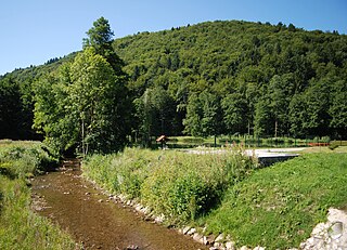
Gabrje is a village in the foothills of the Gorjanci Range in the Municipality of Novo Mesto in southeastern Slovenia, close to the border with Croatia. The entire area is part of the traditional region of Lower Carniola and is now included in the Southeast Slovenia Statistical Region.

Gabrje pri Dobovi is a settlement north of Dobova in the Municipality of Brežice in eastern Slovenia. The area was traditionally part of Styria. It is now included with the rest of the municipality in the Lower Sava Statistical Region.

Gabrje pri Jančah is a settlement in the hills east of Ljubljana in central Slovenia. It belongs to the City Municipality of Ljubljana. It was part of the traditional region of Lower Carniola and is now included with the rest of the municipality in the Central Slovenia Statistical Region.
Gabrje pri Soteski is a small settlement in the Municipality of Dolenjske Toplice in Slovenia. It lies on the left bank of the Krka River on the road between Straža and Soteska. The area is part of the historical region of Lower Carniola. The municipality is now included in the Southeast Slovenia Statistical Region.

Gabrje pri Ilovi Gori is a small settlement in the Municipality of Grosuplje in central Slovenia. It lies just west of the village of Velika Ilova Gora in the historical region of Lower Carniola. The municipality is now included in the Central Slovenia Statistical Region.

Gabrje pri Stični is a settlement just north of Stična in the Municipality of Ivančna Gorica in central Slovenia. The area is part of the historical region of Lower Carniola. The municipality is now included in the Central Slovenia Statistical Region. The settlement includes the hamlets of Kurja Vas, Potok, Pungrt, and Nograd.
Dolnje Brezovo is a small village on the left bank of the Sava River in the Municipality of Sevnica in central Slovenia. The area is part of the historical region of Lower Styria. The municipality is now included in the Lower Sava Statistical Region.

Gornje Brezovo is a settlement in the Municipality of Sevnica in central Slovenia. It lies on the left bank of the Sava River east of Sevnica. The area is part of the historical region of Styria. The municipality is now included in the Lower Sava Statistical Region.
Goveji Dol is a small settlement east of Krmelj in the Municipality of Sevnica in central Slovenia. The area is part of the historical region of Lower Carniola. The municipality is now included in the Lower Sava Statistical Region. In 2006, Brezje, until then a hamlet of Goveji Dol, became an autonomous settlement. In 2008, a part of Goveji Dol and a part of Gabrje merged into a new settlement named Križišče.
Kamenica is a small village northeast of Krmelj in the Municipality of Sevnica in central Slovenia. The area is part of the historical region of Lower Carniola. The municipality is now included in the Lower Sava Statistical Region. Until 2001, the settlement included the area of now autonomous settlement of Kamenško.
Metni Vrh is a dispersed settlement in the hills north of Sevnica in east-central Slovenia. The area is part of the historical region of Lower Styria. The Municipality of Sevnica is now included in the Lower Sava Statistical Region.
Orehovo is a settlement in the Municipality of Sevnica in central Slovenia. It lies on the left bank of the Sava River northwest of Sevnica. The area was traditionally part of Lower Styria. The municipality is now included in the Lower Sava Statistical Region.
Osredek pri Krmelju is a settlement northwest of Krmelj in the Municipality of Sevnica in central Slovenia. The area is part of the historical region of Lower Carniola. The municipality is now included in the Lower Sava Statistical Region. It includes the hamlets of Rupa, Radvanca, Dobovec, Gabrje, Komatca, Oplaz, Kij, and Prinštal.
Otavnik is a settlement southeast of Tržišče in the Municipality of Sevnica in east-central Slovenia. The area is part of the historical region of Lower Carniola. The municipality is included in the Lower Sava Statistical Region.
Žigrski Vrh is a settlement in the Municipality of Sevnica in central Slovenia. It lies in the hills above the left bank of the Sava River east of Sevnica in the historical region of Styria. The municipality is now included in the Lower Sava Statistical Region.
Vranje is a settlement in the Municipality of Sevnica in central Slovenia. It lies in the hills northeast of Sevnica in the historical region of Styria. The municipality is now included in the Lower Sava Statistical Region.

Križišče is a small village in the Municipality of Sevnica in southeastern Slovenia. It lies in the valley of Kamenica Creek, northwest of the road linking Sevnica and Mokronog and east of the road linking Krmelj and Šentjanž. The village became an autonomous settlement in 2008, and was formed from parts of the settlements of Gabrje and Goveji Dol. It is part of the traditional region of Lower Carniola and is included in the Lower Sava Statistical Region. One of the two roads from Krmelj to the main road linking Mokronog and Sevnica runs through the settlement. The rail line from Sevnica to Trebnje runs past the southeastern border of the settlement.
Kamenško is a small village in the Municipality of Sevnica in southeastern Slovenia. It lies on a small rise northeast of Krmelj, east of the road connecting Krmelj and Šentjanž, above and to the north of the villages of Brezje and Kamenica. Until 2001, the area was part of the settlement of Kamenica. The village is part of the traditional region of Lower Carniola and is included in the Lower Sava Statistical Region.
Gabrje is a Slovene place name that may refer to: