
Brezovo is a small settlement in the Sava Hills in the Municipality of Sevnica in central Slovenia. The area is part of the historical region of Styria. The municipality is now included in the Lower Sava Statistical Region.
Dolnje Brezovo is a small village on the left bank of the Sava River in the Municipality of Sevnica in central Slovenia. The area is part of the historical region of Lower Styria. The municipality is now included in the Lower Sava Statistical Region.

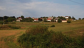
Gornje Brezovo is a settlement in the Municipality of Sevnica in central Slovenia. It lies on the left bank of the Sava River east of Sevnica. The area is part of the historical region of Styria. The municipality is now included in the Lower Sava Statistical Region.
Hinje is a small settlement southwest of Šentjanž in the Municipality of Sevnica in central Slovenia. The municipality is now included in the Lower Sava Statistical Region. The area was traditionally part of the historical region of Lower Carniola. The settlement, which was originally part of Koludrje, was established in January 1998 with a decree of the Municipality of Sevnica from 23 December 1997.

Malkovec is a viticultural settlement along the road on the ridge of Malkovec Hill, southeast of Tržišče, in the Municipality of Sevnica in the Sava region of Slovenia. The municipality is included in the Lower Sava Statistical Region. The area is part of the traditional region of Lower Carniola.
Orehovo is a settlement in the Municipality of Sevnica in central Slovenia. It lies on the left bank of the Sava River northwest of Sevnica. The area was traditionally part of Lower Styria. The municipality is now included in the Lower Sava Statistical Region.
Orešje nad Sevnico is a settlement in the hills north of Sevnica in central Slovenia. The area was traditionally part of the historical region of Styria. The municipality is now included in the Lower Sava Statistical Region.
Otavnik is a settlement southeast of Tržišče in the Municipality of Sevnica in east-central Slovenia. The area is part of the historical region of Lower Carniola. The municipality is included in the Lower Sava Statistical Region.

Pijavice is a small settlement in the Mirna Valley in southeastern Slovenia. The village lies southwest of Krmelj along the railway from Sevnica to Trebnje and the left bank of the Mirna River. Traditionally, it is part of Lower Carniola. Administratively, it is part of the Municipality of Sevnica. The municipality is included in the Lower Sava Statistical Region. The rail line from Sevnica to Trebnje runs through the settlement and has a station there.
Podvrh is a settlement in the Municipality of Sevnica in east-central Slovenia. It lies in the hills northeast of Sevnica in an area that was traditionally part of Styria. The municipality is now included in the Lower Sava Statistical Region.
Polje pri Tržišču is a settlement in the Municipality of Sevnica in east-central Slovenia. It lies south of Krmelj in the traditional region of Lower Carniola. The municipality is now included in the Lower Sava Statistical Region.

Račica is a settlement east of Loka pri Zidanem Mostu on the left bank of the Sava River in the Municipality of Sevnica in east-central Slovenia. The area is part of the historical region of Styria. The municipality is now included in the Lower Sava Statistical Region.
Selce nad Blanco is a small settlement in the hills north of Blanca in the Municipality of Sevnica in east-central Slovenia. Traditionally the area was part of the historical region of Styria and is now included in the Lower Sava Statistical Region.

Spodnje Vodale is a settlement east of Tržišče in the Municipality of Sevnica in east-central Slovenia. The municipality is now included in the Lower Sava Statistical Region. The area was traditionally part Lower Carniola.

Zgornje Vodale is a small settlement in the hills east of Tržišče in the Municipality of Sevnica in central Slovenia. The area is part of the traditional region of Lower Carniola and is included in the Lower Sava Statistical Region.
Škovec is a small settlement south of Tržišče in the Municipality of Sevnica in east-central Slovenia. The area was traditionally part of the historical region of Lower Carniola and is now included in the Lower Sava Statistical Region.

Brezje is a small village in the Municipality of Sevnica in southeastern Slovenia. It lies on a small rise east of Krmelj and the village of Hinjce and west of the Mirna River. Until 2006, the area was part of the settlement of Goveji Dol. The village is part of the traditional region of Lower Carniola and is included in the Lower Sava Statistical Region. One of the two roads from Krmelj to the main road linking Mokronog and Sevnica runs through the settlement, in the valley south of the village core. A cattle trough stands on its right side at the crossroad leading from it into the village. It was built in the 1940s.

Križišče is a small village in the Municipality of Sevnica in southeastern Slovenia. It lies in the valley of Kamenica Creek, northwest of the road linking Sevnica and Mokronog and east of the road linking Krmelj and Šentjanž. The village became an autonomous settlement in 2008, and was formed from parts of the settlements of Gabrje and Goveji Dol. It is part of the traditional region of Lower Carniola and is included in the Lower Sava Statistical Region. One of the two roads from Krmelj to the main road linking Mokronog and Sevnica runs through the settlement. The rail line from Sevnica to Trebnje runs past the southeastern border of the settlement.
Kamenško is a small village in the Municipality of Sevnica in southeastern Slovenia. It lies on a small rise northeast of Krmelj, east of the road connecting Krmelj and Šentjanž, above and to the north of the villages of Brezje and Kamenica. Until 2001, the area was part of the settlement of Kamenica. The village is part of the traditional region of Lower Carniola and is included in the Lower Sava Statistical Region.


