Birna Vas is a settlement in the Municipality of Sevnica in central Slovenia. It lies on the road from Krmelj to Šentjanž in the historical region of Lower Carniola. The municipality is included in the Lower Sava Statistical Region.
Dolnje Brezovo is a small village on the left bank of the Sava River in the Municipality of Sevnica in central Slovenia. The area is part of the historical region of Lower Styria. The municipality is now included in the Lower Sava Statistical Region.
Drušče is a settlement in the hills south of Boštanj in the Municipality of Sevnica in central Slovenia. The area is part of the historical region of Lower Carniola. The municipality is now included in the Lower Sava Statistical Region.

Gornje Brezovo is a settlement in the Municipality of Sevnica in central Slovenia. It lies on the left bank of the Sava River east of Sevnica. The area is part of the historical region of Styria. The municipality is now included in the Lower Sava Statistical Region.
Kamenica is a small village northeast of Krmelj in the Municipality of Sevnica in central Slovenia. The area is part of the historical region of Lower Carniola. The municipality is now included in the Lower Sava Statistical Region. Until 2001, the settlement included the area of now autonomous settlement of Kamenško.
Lončarjev Dol is a settlement in the hills east of Sevnica in east-central Slovenia. The area is part of the historical region of Styria. The entire Municipality of Sevnica is now included in the Lower Sava Statistical Region.

Malkovec is a viticultural settlement along the road on the ridge of Malkovec Hill, southeast of Tržišče, in the Municipality of Sevnica in the Sava region of Slovenia. The municipality is included in the Lower Sava Statistical Region. The area is part of the traditional region of Lower Carniola.
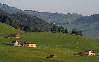
Metni Vrh is a dispersed settlement in the hills north of Sevnica in east-central Slovenia. The area is part of the historical region of Lower Styria. The Municipality of Sevnica is now included in the Lower Sava Statistical Region.
Orehovo is a settlement in the Municipality of Sevnica in central Slovenia. It lies on the left bank of the Sava River northwest of Sevnica. The area was traditionally part of Lower Styria. The municipality is now included in the Lower Sava Statistical Region.
Otavnik is a settlement southeast of Tržišče in the Municipality of Sevnica in east-central Slovenia. The area is part of the historical region of Lower Carniola. The municipality is included in the Lower Sava Statistical Region.
Podgorica is a dispersed settlement in the Municipality of Sevnica in east-central Slovenia. It lies on the slope of Mount Lisca north of Sevnica in the historical region of Styria. The municipality is now included in the Lower Sava Statistical Region.

Skrovnik is a small settlement in the Municipality of Sevnica in east-central Slovenia. It lies on the left bank of the Mirna River northeast of Mokronog on the regional road to Tržišče in the historical region of Lower Carniola. The municipality is now included in the Lower Sava Statistical Region.
Žigrski Vrh is a settlement in the Municipality of Sevnica in central Slovenia. It lies in the hills above the left bank of the Sava River east of Sevnica in the historical region of Styria. The municipality is now included in the Lower Sava Statistical Region.
Vrhek is a settlement in the Municipality of Sevnica in east central Slovenia. It lies in the hills above the left bank of the Mirna River southeast of Krmelj. The area is part of the historical region of Lower Carniola. The municipality is now included in the Lower Sava Statistical Region.
Vranje is a settlement in the Municipality of Sevnica in central Slovenia. It lies in the hills northeast of Sevnica in the historical region of Styria. The municipality is now included in the Lower Sava Statistical Region.

Trščina is a small settlement in the Municipality of Sevnica in east-central Slovenia. It lies in the hills east of Mokronog and south of Tržišče. The area is part of the historical region of Lower Carniola. The municipality is now included in the Lower Sava Statistical Region.
Telčice is a small settlement in the Municipality of Sevnica in central Slovenia. It lies north of Škocjan in the historical region of Lower Carniola. The municipality is now included in the Lower Sava Statistical Region.

Telče is a settlement east of Tržišče in the Municipality of Sevnica in east-central Slovenia. The area is part of the historical region of Lower Carniola. The municipality is now included in the Lower Sava Statistical Region.
Kamenško is a small village in the Municipality of Sevnica in southeastern Slovenia. It lies on a small rise northeast of Krmelj, east of the road connecting Krmelj and Šentjanž, above and to the north of the villages of Brezje and Kamenica. Until 2001, the area was part of the settlement of Kamenica. The village is part of the traditional region of Lower Carniola and is included in the Lower Sava Statistical Region.