Telče | |
---|---|
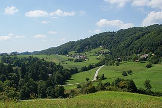
Telče from the southeast | |
Coordinates: 45°57′28.6″N15°15′40.92″E / 45.957944°N 15.2613667°E Coordinates: 45°57′28.6″N15°15′40.92″E / 45.957944°N 15.2613667°E | |
Country | |
Traditional region | Lower Carniola |
Statistical region | Lower Sava |
Municipality | Sevnica |
Area | |
• Total | 2.4 km2 (0.9 sq mi) |
Elevation | 488.9 m (1,604.0 ft) |
Population (2012) | |
• Total | 79 |
• Density | 33/km2 (90/sq mi) |
[1] |
Telče (pronounced [ˈteːu̯tʃɛ] ; German : Teltsche [2] ) is a settlement east of Tržišče in the Municipality of Sevnica in east-central Slovenia. The area is part of the historical region of Lower Carniola. The municipality is now included in the Lower Sava Statistical Region. [3]
German is a West Germanic language that is mainly spoken in Central Europe. It is the most widely spoken and official or co-official language in Germany, Austria, Switzerland, South Tyrol (Italy), the German-speaking Community of Belgium, and Liechtenstein. It is also one of the three official languages of Luxembourg and a co-official language in the Opole Voivodeship in Poland. The languages which are most similar to German are the other members of the West Germanic language branch: Afrikaans, Dutch, English, the Frisian languages, Low German/Low Saxon, Luxembourgish, and Yiddish. There are also strong similarities in vocabulary with Danish, Norwegian and Swedish, although those belong to the North Germanic group. German is the second most widely spoken Germanic language, after English.
Tržišče is a settlement along the road linking Mokronog and Sevnica in the Lower Carniola region in east-central Slovenia. It is part of the Municipality of Sevnica, which is included in the Lower Sava Statistical Region. St. George's Hill lies to the northwest of the village. The rail line from Sevnica to Trebnje runs through the settlement and has a station there. The settlement includes the hamlets of Mostec and Sveta Trojica.
The Municipality of Sevnica is a municipality along the Sava and the Mirna Rivers in southeastern Slovenia. The seat of the municipality is the town of Sevnica. Today it is part of the Lower Sava Statistical Region. It is the 12th-largest municipality by area in Slovenia.
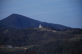
The local church, built in an isolated location northwest of the settlement core, is dedicated to Saint James (Slovene : sveti Jakob) and belongs to the Parish of Škocjan pri Novem Mestu. It dates to the 16th or 17th century. [4]
A church building or church house, often simply called a church, is a building used for Christian religious activities, particularly for Christian worship services. The term is often used by Christians to refer to the physical buildings where they worship, but it is sometimes used to refer to buildings of other religions. In traditional Christian architecture, the church is often arranged in the shape of a Christian cross. When viewed from plan view the longest part of a cross is represented by the aisle and the junction of the cross is located at the altar area.
James, son of Zebedee was one of the Twelve Apostles of Jesus, traditionally considered the first apostle to be martyred.
Slovene or Slovenian belongs to the group of South Slavic languages. It is spoken by approximately 2.5 million speakers worldwide, the majority of whom live in Slovenia. It is the first language of about 2.1 million Slovenian people and is one of the 24 official and working languages of the European Union.
Drožanje is a settlement just north of Sevnica in east-central Slovenia. The area is part of the historical region of Styria. The Municipality of Sevnica is now included in the Lower Sava Statistical Region.
Drušče is a settlement in the hills south of Boštanj in the Municipality of Sevnica in central Slovenia. The area is part of the historical region of Lower Carniola. The municipality is now included in the Lower Sava Statistical Region.
Čanje is a settlement in the hills above Blanca in the Municipality of Sevnica in central Slovenia. The area is part of the historical region of Styria. The municipality is now included in the Lower Sava Statistical Region.
Gornje Brezovo is a settlement in the Municipality of Sevnica in central Slovenia. It lies on the left bank of the Sava River east of Sevnica. The area is part of the historical region of Styria. The municipality is now included in the Lower Sava Statistical Region.
Kamenica is a small village northeast of Krmelj in the Municipality of Sevnica in central Slovenia. The area is part of the historical region of Lower Carniola. The municipality is now included in the Lower Sava Statistical Region. Until 2001, the settlement included the area of now autonomous settlement of Kamenško.
Lončarjev Dol is a settlement in the hills east of Sevnica in east-central Slovenia. The area is part of the historical region of Styria. The entire Municipality of Sevnica is now included in the Lower Sava Statistical Region.
Lukovec is a small settlement in the Municipality of Sevnica in east-central Slovenia. It lies above the right bank of the Sava River east of Boštanj. The area is part of the historical region of Lower Carniola. The municipality is now included in the Lower Sava Statistical Region.
Metni Vrh is a dispersed settlement in the hills north of Sevnica in east-central Slovenia. The area is part of the historical region of Lower Styria. The Municipality of Sevnica is now included in the Lower Sava Statistical Region.
Mrzla Planina is a dispersed settlement in the hills northeast of Sevnica in east-central Slovenia. The area is part of the historical region of Styria. The municipality is now included in the Lower Sava Statistical Region.
Okroglice is a settlement in the hills northeast of Loka pri Zidanem Mostu in the Municipality of Sevnica in east-central Slovenia. The area is part of the historical region of Styria. The municipality is now included in the Lower Sava Statistical Region.
Pavla Vas is a settlement south of Tržišče in the Municipality of Sevnica in east-central Slovenia. The area is part of the historical region of Lower Carniola. The municipality is now included in the Lower Sava Statistical Region.
Pečje is a settlement in the Municipality of Sevnica in central Slovenia. It lies just east of Sevnica above the left bank of the Sava River The area is part of the historical region of Styria. The municipality is now included in the Lower Sava Statistical Region.
Radna is a settlement in the Municipality of Sevnica in east-central Slovenia. It lies at the confluence of the Mirna River and the Sava River in the historical region of Lower Carniola. The municipality is now included in the Lower Sava Statistical Region.
Žigrski Vrh is a settlement in the Municipality of Sevnica in central Slovenia. It lies in the hills above the left bank of the Sava River east of Sevnica in the historical region of Styria. The municipality is now included in the Lower Sava Statistical Region.
Vrhek is a settlement in the Municipality of Sevnica in east central Slovenia. It lies in the hills above the left bank of the Mirna River southeast of Krmelj. The area is part of the historical region of Lower Carniola. The municipality is now included in the Lower Sava Statistical Region.
Vranje is a settlement in the Municipality of Sevnica in central Slovenia. It lies in the hills northeast of Sevnica in the historical region of Styria. The municipality is now included in the Lower Sava Statistical Region.
Trnovec is a settlement in the hills northeast of Sevnica in east-central Slovenia. The area is part of the historical region of Styria. The Municipality of Sevnica is now included in the Lower Sava Statistical Region.
Križišče is a small village in the Municipality of Sevnica in southeastern Slovenia. It lies in the valley of Kamenica Creek, northwest of the road linking Sevnica and Mokronog and east of the road linking Krmelj and Šentjanž. The village became an autonomous settlement in 2008, and was formed from parts of the settlements of Gabrje and Goveji Dol. It is part of the traditional region of Lower Carniola and is included in the Lower Sava Statistical Region. One of the two roads from Krmelj to the main road linking Mokronog and Sevnica runs through the settlement. The rail line from Sevnica to Trebnje runs past the southeastern border of the settlement.
Kamenško is a small village in the Municipality of Sevnica in southeastern Slovenia. It lies on a small rise northeast of Krmelj, east of the road connecting Krmelj and Šentjanž, above and to the north of the villages of Brezje and Kamenica. Until 2001, the area was part of the settlement of Kamenica. The village is part of the traditional region of Lower Carniola and is included in the Lower Sava Statistical Region.