Obluchye is a town and the administrative center of Obluchensky District in the Jewish Autonomous Oblast, Russia, located on the Amur River, 159 kilometers (99 mi) west of Birobidzhan, the administrative center of the autonomous oblast. Population: 9,379 (2010 Census); 11,069 (2002 Census); 12,016 (1989 Census).

Beryozovsky is a town in Kemerovo Oblast, Russia, located between the Barzas and Shurap Rivers, 27 kilometers (17 mi) north of Kemerovo, the administrative center of the oblast. Population: 47,279 (2010 Census); 48,299 (2002 Census); 51,250 (1989 Census).

Oktyabrsky District is an administrative and municipal district (raion), one of the twenty in Amur Oblast, Russia. The area of the district is 3,381 square kilometers (1,305 sq mi). Its administrative center is the rural locality of Yekaterinoslavka. Population: 19,679 (2010 Census); 22,761 ; 23,127 (1989 Census). The population of Yekaterinoslavka accounts for 49.4% of the district's total population.

Birobidzhansky District is an administrative and municipal district (raion), one of the five in the Jewish Autonomous Oblast, Russia. It is located in the center of the autonomous oblast. The area of the district is 4,442.56 square kilometers (1,715.28 sq mi). Its administrative center is the town of Birobidzhan. Population: 11,907 ; 13,018 (2002 Census); 15,437 (1989 Census).
Leninsky District is an administrative and municipal district (raion), one of the five in the Jewish Autonomous Oblast, Russia. It is located in the south and center of the autonomous oblast. The area of the district is 6,068 square kilometers (2,343 sq mi). Its administrative center is the rural locality of Leninskoye. Population: 20,684 ; 22,844 (2002 Census); 28,464 (1989 Census). The population of Leninskoye accounts for 29.5% of the district's total population.

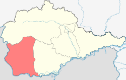
Obluchensky District is an administrative and municipal district (raion), one of the five in the Jewish Autonomous Oblast, Russia. It is located in the north, east, and center of the autonomous oblast. The area of the district is 13,300 square kilometers (5,100 sq mi). Its administrative center is the town of Obluchye. Population: 29,035 ; 36,515 (2002 Census); 43,062 (1989 Census). The population of Obluchye accounts for 32.3% of the district's total population.

Smidovichsky District is an administrative and municipal district (raion), one of the five in the Jewish Autonomous Oblast, Russia. It is located in the east of the autonomous oblast and borders Khabarovsk Krai in the north and east, China in the south, and Birobidzhansky District in the west. The area of the district is 5,900 square kilometers (2,300 sq mi). Its administrative center is the urban locality of Smidovich. As of the 2010 Census, the total population of the district was 28,165, with the population of Smidovich accounting for 18.2% of that number.

Novokuznetsky District is an administrative district (raion), one of the nineteen in Kemerovo Oblast, Russia. As a municipal division, it is incorporated as Novokuznetsky Municipal District. It is located in the center of the oblast and spans it from border to border in the southwest-northeast direction. The area of the district is 13,039.5989 square kilometers (5,034.6173 sq mi). Its administrative center is the city of Novokuznetsk. As of the 2010 Census, the total population of the district was 50,681.

Kashirsky District is an administrative and municipal district (raion), one of the thirty-six in Moscow Oblast, Russia. It is located in the south of the oblast. The area of the district is 646.09 square kilometers (249.46 sq mi). Its administrative center is the town of Kashira. Population: 70,269 (2010 Census); 70,774 ; 35,300 (1989 Census). The population of Kashira accounts for 59.6% of the district's total population.

Lukhovitsky District is an administrative and municipal district (raion), one of the thirty-six in Moscow Oblast, Russia. It is located in the southeast of the oblast. The area of the district is 1,340.52 square kilometers (517.58 sq mi). Its administrative center is the town of Lukhovitsy. Population: 58,802 ; 63,235 (2002 Census); 65,534 (1989 Census). The population of Lukhovitsy accounts for 50.8% of the district's total population.

Ruzsky District is an administrative and municipal district (raion), one of the thirty-six in Moscow Oblast, Russia. It is located in the west of the oblast. The area of the district is 1,567.56 square kilometers (605.24 sq mi). Its administrative center is the town of Ruza. Population: 61,673 ; 63,685 (2002 Census); 67,533 (1989 Census). The population of Ruza accounts for 21.9% of the district's total population.

Voskresensky District is an administrative and municipal district (raion), one of the thirty-six in Moscow Oblast, Russia. It is located in the east of the oblast. The area of the district is 812.480 square kilometers (313.700 sq mi). Its administrative center is the town of Voskresensk. Population: 153,600 ; 152,761 (2002 Census); 77,573 (1989 Census). The population of Voskresensk accounts for 59.5% of the district's total population.

Mtsensky District is an administrative and municipal district (raion), one of the twenty-four in Oryol Oblast, Russia. It is located in the north of the oblast. The area of the district is 1,665.8 square kilometers (643.2 sq mi). Its administrative center is the town of Mtsensk. Population: 19,233 ; 20,757 (2002 Census); 22,317 (1989 Census).
Yekaterinoslavka is a rural locality and the administrative center of Oktyabrsky District of Amur Oblast, Russia. Population: 9,723 (2010 Census); 10,584 (2002 Census); 9,197 (1989 Census).
Krasnaya Gorbatka is an urban-type settlement and the administrative center of Selivanovsky District, Vladimir Oblast, Russia. Population: 8,885 (2010 Census); 9,441 (2002 Census); 10,493 (1989 Census).
Bolshiye Uki is a rural locality and the administrative center of Bolsheukovsky District, Omsk Oblast, Russia. Population: 4,157 (2010 Census); 4,384 (2002 Census); 5,719 (1989 Census).
Nizhnyaya Omka is a rural locality and the administrative center of Nizhneomsky District, Omsk Oblast, Russia. Population: 4,821 (2010 Census); 5,310 (2002 Census); 5,361 (1989 Census).
Odesskoye is a rural locality and the administrative center of Odessky District, Omsk Oblast, Russia. Population: 6,148 (2010 Census); 6,098 (2002 Census); 6,000 (1989 Census).
Sedelnikovo is a rural locality and the administrative center of Sedelnikovsky District, Omsk Oblast, Russia. Population: 5,316 (2010 Census); 5,055 (2002 Census); 5,132 (1989 Census).
Ust-Ishim is a rural locality and the administrative center of Ust-Ishimsky District, Omsk Oblast, Russia. Population: 4,802 (2010 Census); 5,060 (2002 Census); 5,795 (1989 Census).