Leninsky District, Jewish Autonomous Oblast

Last updated
Leninsky District
Ленинский район(Russian)
Location of Leninsky District (Jewish AO).svg
Location of Leninsky District in the Jewish Autonomous Oblast
Coordinates: 47°56′30″N132°37′05″E / 47.94167°N 132.61806°E / 47.94167; 132.61806 Coordinates: 47°56′30″N132°37′05″E / 47.94167°N 132.61806°E / 47.94167; 132.61806
Coat of Arms of Leninsky rayon (Jewish AO).png
Coat of arms
Location
Country Russia
Federal subject Jewish Autonomous Oblast [1]
Administrative structure (as of July 2011)
Administrative center selo of  Leninskoye [1]
Inhabited localities: [1]
Rural localities 24
Municipal structure (as of May 2010)
Municipally incorporated asLeninsky Municipal District [2]
Municipal divisions: [3]
Urban settlements0
Rural settlements5
Statistics
Area 6,068 km2 (2,343 sq mi) [4]
Population (2010 Census) 20,684 inhabitants [5]
 Urban0%
 Rural100%
Density 3.41/km2 (8.8/sq mi) [6]
Time zone VLAT (UTC+10:00) [7]
Established1934 [4]
Official website
Leninsky District on WikiCommons

Leninsky District (Russian : Ле́нинский райо́н) is an administrative [1] and municipal [2] district (raion), one of the five in the Jewish Autonomous Oblast, Russia. It is located in the south and center of the autonomous oblast. The area of the district is 6,068 square kilometers (2,343 sq mi). [4] Its administrative center is the rural locality (a selo ) of Leninskoye. [1] Population: 20,684 (2010 Census); [5] 22,844(2002 Census); [8] 28,464(1989 Census). [9] The population of Leninskoye accounts for 29.5% of the district's total population. [5]

Russian language East Slavic language

Russian is an East Slavic language, which is official in the Russian Federation, Belarus, Kazakhstan and Kyrgyzstan, as well as being widely used throughout Eastern Europe, the Baltic states, the Caucasus and Central Asia. It was the de facto language of the Soviet Union until its dissolution on 25 December 1991. Although nearly three decades have passed since the breakup of the Soviet Union, Russian is used in official capacity or in public life in all the post-Soviet nation-states, as well as in Israel and Mongolia.

A raion is a type of administrative unit of several post-Soviet states. The term is from the French "rayon", which is both a type of a subnational entity and a division of a city, and is commonly translated in English as "district".

Contents

Geography

Leninsky District is located in the south central region of the Jewish Autonomous Oblast. About 132 km of the Amur River runs along the southern border of Leninsky. The district is about 160 km west of the city of Khabarovsk, and the area measures 90 km (north-south) by 100 km (west-east). About 60% of the district is on the Middle Plain of the Amur River, with the remainder on the northern foothills of the Lesser Khingan mountains. The area has commercial deposits of building materials: granite, sandstone, clay and gravel. [4]

Amur River river in Russia and China

The Amur River or Heilong Jiang is the world's tenth longest river, forming the border between the Russian Far East and Northeastern China. The largest fish species in the Amur is the kaluga, attaining a length as great as 5.6 metres (18 ft). The river basin is home to a variety of large predatory fish such as northern snakehead, Amur pike, taimen, Amur catfish, predatory carp and yellowcheek, as well as the northernmost populations of the Amur softshell turtle and Indian lotus.

Khabarovsk City in Khabarovsk Krai, Russia

Khabarovsk is the largest city and the administrative center of Khabarovsk Krai, Russia, located 30 kilometers (19 mi) from the Chinese border, at the confluence of the Amur and Ussuri Rivers, about 800 kilometers (500 mi) north of Vladivostok. The city was the administrative center of the Far Eastern Federal District of Russia from 2002 until December 2018, when Vladivostok took over that role. It is the second largest city in the Russian Far East, after Vladivostok. As of the 2010 Census, its population was 577,441. It was previously known as Khabarovka. Khabarovsk is the closest major city to Birobidzhan, which is a town and the administrative center of the Jewish Autonomous Oblast.

Lesser Khingan mountain range

Lesser Khingan is a mountain range in China's Heilongjiang Province and the adjacent parts of Russia's Amur Oblast and Jewish Autonomous Oblast.

The district is bordered on the north by Obluchensky District, on the west by Oktyabrsky District, on the east by Birobidzhansky District, on the south across the Amur is China.

Obluchensky District District in Jewish Autonomous Oblast, Russia

Obluchensky District is an administrative and municipal district (raion), one of the five in the Jewish Autonomous Oblast, Russia. It is located in the north, east, and center of the autonomous oblast. The area of the district is 13,300 square kilometers (5,100 sq mi). Its administrative center is the town of Obluchye. Population: 29,035 ; 36,515 (2002 Census); 43,062 (1989 Census). The population of Obluchye accounts for 32.3% of the district's total population.

Oktyabrsky District is an administrative and municipal district (raion), one of the five in the Jewish Autonomous Oblast, Russia. It is located in the west and southwest of the autonomous oblast. The area of the district is 6,400 square kilometers (2,500 sq mi). Its administrative center is the rural locality of Amurzet. Population: 11,354 ; 13,095 (2002 Census); 15,599 (1989 Census). The population of Amurzet accounts for 44.5% of the district's total population.

Birobidzhansky District District in Jewish Autonomous Oblast, Russia

Birobidzhansky District is an administrative and municipal district (raion), one of the five in the Jewish Autonomous Oblast, Russia. It is located in the center of the autonomous oblast. The area of the district is 4,442.56 square kilometers (1,715.28 sq mi). Its administrative center is the town of Birobidzhan. Population: 11,907 ; 13,018 (2002 Census); 15,437 (1989 Census).

History

After the area came under the official control of Russia in 1858, after the Treaty of Aigun with China, the Russian government resettled Trans-Baikal Cossacks into the district to provide a military presence. Volunteers were insufficient, so settlers were selected by lot and relocated down the Amur River on rafts with their families. [10] District was officially constituted in 1934. [4]

Treaty of Aigun 1858 inequal treaty between Russian Empire and Manchu Chinese Empire

The Treaty of Aigun was an 1858 treaty between the Russian Empire, and the empire of the Qing Dynasty, the Manchu rulers of China, that established much of the modern border between the Russian Far East and Manchuria, which is now known as Northeast China. It reversed the Treaty of Nerchinsk (1689) by transferring the land between the Stanovoy Range and the Amur River from China to the Russian Empire. Russia received over 600,000 square kilometres (231,660 sq mi) from China.

Related Research Articles

Magdagachi work settlement in Amur Oblast, Russia

Magdagachi is an urban locality and the administrative center of Magdagachinsky District of Amur Oblast, Russia, located 367 kilometers (228 mi) northwest of Blagoveshchensk. Population: 10,897 (2010 Census); 12,208 (2002 Census); 15,578 (1989 Census).

Obluchye, Jewish Autonomous Oblast Town in Jewish Autonomous Oblast, Russia

Obluchye is a town and the administrative center of Obluchensky District in the Jewish Autonomous Oblast, Russia, located on the Amur River, 159 kilometers (99 mi) west of Birobidzhan, the administrative center of the autonomous oblast. Population: 9,379 (2010 Census); 11,069 (2002 Census); 12,016 (1989 Census).

Arkharinsky District District in Amur Oblast, Russia

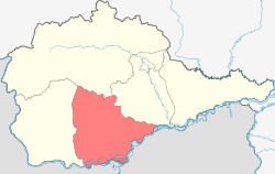
Arkharinsky District is an administrative and municipal district (raion), one of the twenty in Amur Oblast, Russia. The area of the district is 14,355 square kilometers (5,542 sq mi). Its administrative center is the urban locality of Arkhara. Population: 17,186 (2010 Census); 21,068 ; 27,537 (1989 Census). The population of Arkhara accounts for 55.8% of the district's total population.

Konstantinovsky District, Amur Oblast District in Amur Oblast, Russia

Konstantinovsky District is an administrative and municipal district (raion), one of the twenty in Amur Oblast, Russia. The area of the district is 1,816 square kilometers (701 sq mi). Its administrative center is the rural locality of Konstantinovka. Population: 12,986 (2010 Census); 14,847 ; 16,710 (1989 Census). The population of Konstantinovka accounts for 41.0% of the district's total population.

Mazanovsky District District in Amur Oblast, Russia

Mazanovsky District is an administrative and municipal district (raion), one of the twenty in Amur Oblast, Russia. The area of the district is 28,316 square kilometers (10,933 sq mi). Its administrative center is the rural locality of Novokiyevsky Uval. Population: 14,803 (2010 Census); 16,028 ; 20,393 (1989 Census). The population of Novokiyevsky Uval accounts for 29.2% of the district's total population.

Oktyabrsky District, Amur Oblast District in Amur Oblast, Russia

Oktyabrsky District is an administrative and municipal district (raion), one of the twenty in Amur Oblast, Russia. The area of the district is 3,381 square kilometers (1,305 sq mi). Its administrative center is the rural locality of Yekaterinoslavka. Population: 19,679 (2010 Census); 22,761 ; 23,127 (1989 Census). The population of Yekaterinoslavka accounts for 49.4% of the district's total population.

Romnensky District District in Amur Oblast, Russia

Romnensky District is an administrative and municipal district (raion), one of the twenty in Amur Oblast, Russia. The area of the district is 10,066 square kilometers (3,887 sq mi). Its administrative center is the rural locality of Romny. Population: 9,401 (2010 Census); 11,822 ; 15,651 (1989 Census). The population of Romny accounts for 32.8% of the district's total population.

Selemdzhinsky District District in Amur Oblast, Russia

Selemdzhinsky District is an administrative and municipal district (raion), one of the twenty in Amur Oblast, Russia. The area of the district is 46,672 square kilometers (18,020 sq mi). Its administrative center is the urban locality of Ekimchan. Population: 11,639 (2010 Census); 11,808 ; 20,632 (1989 Census). The population of Ekimchan accounts for 10.4% of the district's total population.

Seryshevsky District District in Amur Oblast, Russia

Seryshevsky District is an administrative and municipal district (raion), one of the twenty in Amur Oblast, Russia. The area of the district is 3,805 square kilometers (1,469 sq mi). Its administrative center is the urban locality of Seryshevo. Population: 25,725 (2010 Census); 29,440 ; 35,969 (1989 Census). The population of Seryshevo accounts for 42.0% of the district's population.

Skovorodinsky District District in Amur Oblast, Russia

Skovorodinsky District is an administrative and municipal district (raion), one of the twenty in Amur Oblast, Russia. The area of the district is 20,509 square kilometers (7,919 sq mi). Its administrative center is the town of Skovorodino. Population: 29,558 (2010 Census); 34,269 ; 42,998 (1989 Census). The population of Skovorodino accounts for 32.4% of the district's total population.

Smidovichsky District District in Jewish Autonomous Oblast, Russia

Smidovichsky District is an administrative and municipal district (raion), one of the five in the Jewish Autonomous Oblast, Russia. It is located in the east of the autonomous oblast and borders Khabarovsk Krai in the north and east, China in the south, and Birobidzhansky District in the west. The area of the district is 5,900 square kilometers (2,300 sq mi). Its administrative center is the urban locality of Smidovich. As of the 2010 Census, the total population of the district was 28,165, with the population of Smidovich accounting for 18.2% of that number.

Leninsky District, Moscow Oblast District in Moscow Oblast, Russia

Leninsky District is an administrative and municipal district (raion), one of the thirty-six in Moscow Oblast, Russia. It is located in the center of the oblast just south of the federal city of Moscow. The area of the district is 202.83 square kilometers (78.31 sq mi). Its administrative center is the town of Vidnoye. Population: 172,171 (2010 Census); 145,251 ; 74,490 (1989 Census). The population of Vidnoye accounts for 33.0% of the district's total population.

Ekimchan Work settlement in Amur Oblast, Russia

Ekimchan is an urban locality and the administrative center of Selemdzhinsky District of Amur Oblast, Russia, located on the right bank of the Selemdzha River. Population: 1,212 (2010 Census); 1,224 (2002 Census); 1,832 (1989 Census).

Lazarevo, Jewish Autonomous Oblast Town in Jewish Autonomous Oblast, Russia

Lazarevo is a small town in Leninsky District in the Jewish Autonomous Oblast, Russia. It is the head of Lazarevskoye Rural Settlement.

Tambovka is a rural locality and the administrative center of Tambovsky District of Amur Oblast, Russia. Population: 7,6,173 (2010 Census); 8,147 (2002 Census); 8,828 (1989 Census).

Talakan work settlement in Amur Oblast, Russia

Talakan is an urban locality in Bureysky District of Amur Oblast, Russia. Population: 5,176 (2010 Census); 6,545 (2002 Census); 4,479 (1989 Census).

Sivaki, Russia work settlement in Amur Oblast, Russia

Sivaki is an urban locality in Magdagachinsky District of Amur Oblast, Russia. Population: 2,056 (2010 Census); 2,578 (2002 Census); 3,721 (1989 Census).

References

Notes

  1. 1 2 3 4 5 Law #982-OZ
  2. 1 2 Law #231-OZ
  3. Law #337-OZ
  4. 1 2 3 4 5 "General Information" (in Russian). Leninsky District. Retrieved August 31, 2016.
  5. 1 2 3 Russian Federal State Statistics Service (2011). "Всероссийская перепись населения 2010 года. Том 1" [2010 All-Russian Population Census, vol. 1]. Всероссийская перепись населения 2010 года (2010 All-Russia Population Census) (in Russian). Federal State Statistics Service . Retrieved June 29, 2012.
  6. The value of density was calculated automatically by dividing the 2010 Census population by the area specified in the infobox. Please note that this value is only approximate as the area specified in the infobox does not necessarily correspond to the area of the entity proper or is reported for the same year as the population.
  7. Правительство Российской Федерации. Федеральный закон №107-ФЗ от 3 июня 2011 г. «Об исчислении времени», в ред. Федерального закона №271-ФЗ от 03 июля 2016 г. «О внесении изменений в Федеральный закон "Об исчислении времени"». Вступил в силу по истечении шестидесяти дней после дня официального опубликования (6 августа 2011 г.). Опубликован: "Российская газета", №120, 6 июня 2011 г. (Government of the Russian Federation. Federal Law #107-FZ of June 31, 2011 On Calculating Time , as amended by the Federal Law #271-FZ of July 03, 2016 On Amending Federal Law "On Calculating Time". Effective as of after sixty days following the day of the official publication.).
  8. Russian Federal State Statistics Service (May 21, 2004). "Численность населения России, субъектов Российской Федерации в составе федеральных округов, районов, городских поселений, сельских населённых пунктов – районных центров и сельских населённых пунктов с населением 3 тысячи и более человек" [Population of Russia, Its Federal Districts, Federal Subjects, Districts, Urban Localities, Rural Localities—Administrative Centers, and Rural Localities with Population of Over 3,000](XLS). Всероссийская перепись населения 2002 года [All-Russia Population Census of 2002] (in Russian). Retrieved August 9, 2014.
  9. Demoscope Weekly (1989). "Всесоюзная перепись населения 1989 г. Численность наличного населения союзных и автономных республик, автономных областей и округов, краёв, областей, районов, городских поселений и сёл-райцентров" [All Union Population Census of 1989: Present Population of Union and Autonomous Republics, Autonomous Oblasts and Okrugs, Krais, Oblasts, Districts, Urban Settlements, and Villages Serving as District Administrative Centers]. Всесоюзная перепись населения 1989 года [All-Union Population Census of 1989] (in Russian). Институт демографии Национального исследовательского университета: Высшая школа экономики [Institute of Demography at the National Research University: Higher School of Economics]. Retrieved August 9, 2014.
  10. "History of the District". Leninsky District. Retrieved October 30, 2016.

Sources