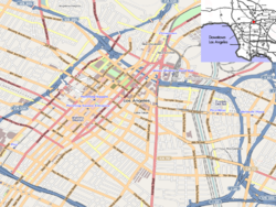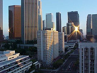
Downtown Los Angeles (DTLA) is the central business district of Los Angeles, California. In addition, it contains a diverse residential area of some 85,000 people, and covers 5.84 sq mi (15.1 km2). A 2013 study found that the district is home to over 500,000 jobs. It is also part of Central Los Angeles.

West Adams is a historic neighborhood in the South Los Angeles region of Los Angeles, California. The area is known for its large number of historic buildings, structures and notable houses and mansions throughout Los Angeles. It is a youthful, densely populated area with a high percentage of African American and Latino residents. The neighborhood has several public and private schools.

Los Angeles Trade–Technical College is a public community college in Los Angeles, California. It offers academic courses towards 4-year colleges and vocational training programs. It is part of the Los Angeles Community College District and is accredited by the Accrediting Commission for Community and Junior Colleges (ACCJC), Western Association of Schools and Colleges, The American Culinary Federation, and the National League of Nursing among others.

Jefferson Park is a neighborhood in the South region of the City of Los Angeles, California.
The Historic Core is a district within Downtown Los Angeles includes the world's largest concentration of movie palaces, former large department stores, and office towers, all built chiefly between 1907 and 1931. Within it lie the Broadway Theater District and the Spring Street historic financial district, and in its west it overlaps with the Jewelry District and in its east with Skid Row.

Gallery Row is a neighborhood in Downtown Los Angeles designated by the City Council in 2003 to promote the concentration of art galleries along Main Street and Spring Street.

The Arts District is a neighborhood on the eastern edge of Downtown Los Angeles, California in the United States. The city community planning boundaries are Alameda Street on the west which blends into Little Tokyo, First Street on the north, the Los Angeles River to the east, and Violet Street on the south. Largely composed of industrial buildings dating from the early 20th century, the area has recently been revitalized, and its street scene slowly developed in the early the 21st century. New art galleries have increased recognition of the area amidst the entire downtown where other art museums are found.

Saint Sophia Greek Orthodox Cathedral is a Greek Orthodox church built in 1952, in what was then the Greek section of Central Los Angeles, California. It is located at West 15th Street and South Normandie Avenue in the present-day Harvard Heights neighborhood.

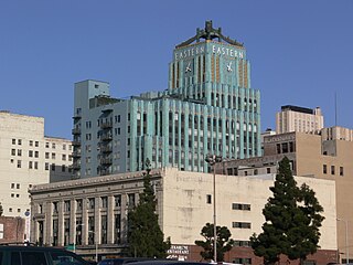
The Eastern Columbia Building, also known as the Eastern Columbia Lofts, is a thirteen-story Art Deco building designed by Claud Beelman located at 849 S. Broadway in the Broadway Theater District of Downtown Los Angeles. It opened on September 12, 1930, after just nine months of construction. It was built at a cost of $1.25 million as the new headquarters and 39th store for the Eastern-Columbia Department Store, whose component Eastern and Columbia stores were founded by Adolph Sieroty and family. At the time of construction, the City of Los Angeles enforced a height limit of 150 feet (46 m), however the decorative clock tower was granted an exemption, allowing the clock a total height of 264 feet (80 m).
Outpost Estates is a neighborhood in the Hollywood Hills of Los Angeles, California, consisting of about 450 homes. It is bordered by Mulholland Drive to the north, Franklin Avenue to the south, Runyon Canyon Park to the west, and Hollywood Heights and the Hollywood Bowl to the east.

Tom Gilmore is a downtown Los Angeles-based developer of residential and commercial properties.

The Security Building is an 11-story high-rise building located at 510 South Spring Street within the Spring Street Financial District in Downtown Los Angeles, California. It has been converted to the residential Lofts at the Security Building.

The Hollywood Subway, as it is most commonly known, officially the Belmont Tunnel, was a subway tunnel used by the interurban streetcars of the Pacific Electric Railway. It ran from its northwest entrance in today's Westlake district to the Subway Terminal, in the Historic Core, the business and commercial center of the city from around the 1910s through the 1950s. The Subway Terminal was one of the Pacific Electric Railway’s two main hubs, the other being 6th and Main. Streetcars of numerous Pacific Electric lines proceeded from the San Fernando Valley, Glendale, Santa Monica and Hollywood into the tunnel in Westlake and traveled southeast under Crown and Bunker Hill towards the Subway Terminal.

The San Fernando Building is an Italian Renaissance Revival style building built in 1906 at 400–410 S. Main Street in the Historic Core district of downtown Los Angeles, California. It was listed in the National Register of Historic Places in 1986, converted into lofts in 2000, and declared a Historic-Cultural Monument in 2002.
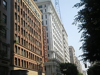
Spring Street in Los Angeles is one of the oldest streets in the city. Along Spring Street in Downtown Los Angeles, from just north of Fourth Street to just south of Seventh Street is the NRHP-listed Spring Street Financial District, nicknamed Wall Street of the West, lined with Beaux Arts buildings and currently experiencing gentrification. This section forms part of the Historic Core district of Downtown, together with portions of Hill, Broadway, Main and Los Angeles streets.
The Biscuit Company Lofts is a 7-story building in Los Angeles, California. Built in 1925 as a factory, the building was converted to live/work lofts in 2006.
Main Street is a major north–south thoroughfare in Los Angeles, California. It serves as the east–west postal divider for the city and the county as well.

Hill Street is a major north–south thoroughfare in Los Angeles, measuring 4.8 miles (7.7 km) in length. It starts on Martin Luther King, Jr. Boulevard near the campus of USC, and passes north through Downtown Los Angeles, past such landmarks as Pershing Square, the Subway Terminal Building, Angels Flight, Fort Moore and Chinatown. Hill Street merges with the Arroyo Seco Parkway near Dodger Stadium.

The St. Vincent's Place is the second location of Saint Vincent College in Central Los Angeles, California. St. Vincent's Place was designated a California Historic Landmark (No.567) on Feb. 25, 1957. St. Vincent's College was started by Vincentian Fathers in 1865 and was the first College in Southern California. St. Vincent's Place is located at St. Vincent's Court at 7th Street and Broadway in the City of Los Angeles in Los Angeles County. St. Vincent's College became L.A. College in 1911 and Loyola Marymount University in 1917. Saint Vincent's College used the Downtown Los Angeles site from 1868 to 1887. Broadway was call Fort Street in 1868. St. Vincent's Court is now a small alley running through the center of the former Bullock's complex, this was the main entrance to St. Vincent’s College in 1868, a keen city promoter remodeled it as a imitation of a European village square.
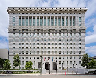
The Hall of Justice in Los Angeles is located at 211 W. Temple Street in the Civic Center district of Downtown Los Angeles. It occupies the southern two-thirds of the block between Temple and First streets and between Broadway and Spring streets.