Financial District, Los Angeles

Last updated
Financial District
L.A Financial district.JPG
The Financial District as viewed from Bunker Hill
Los Angeles Downtown locator.PNG
Red pog.svg
Financial District
Location within Downtown Los Angeles
Coordinates: 34°03′03″N118°15′18″W / 34.05083°N 118.25500°W / 34.05083; -118.25500
CountryFlag of the United States (23px).png  United States
StateFlag of California.svg  California
County County of Los Angeles
CityFlag of Los Angeles, California.svg  Los Angeles
Area code 213

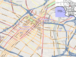
The Financial District (Financial Core) is the central business district of Los Angeles along Olive, Grand, Hope, Flower and Figueroa streets from 4th Street to 8th Street. It is south of the Bunker Hill district, west of the Historic Core, north of South Park and east of the Harbor Freeway and Central City West. [1] Like Bunker Hill, the Financial District is home to corporate office skyscrapers, hotels and related services as well as banks, law firms, and real estate companies. However, unlike Bunker Hill which was razed and now consists of buildings constructed since the 1960s, it contains large buildings from the early 20th century, particularly along Seventh Street, once the city's upscale shopping street; the area also attracts visitors as the 7th and Flower area is at the center of the regional Metro rail system and is replete with restaurants, bars, and shopping at two urban malls.

Contents

History

What is now the Financial District was originally agricultural land, then a residential area of single family homes, then around 1900 started attracting businesses as Victorian-era Downtown L.A. expanded south along Broadway past 3rd Street and "around the corner", west along Seventh Street. Around 1915, 7th Street between Broadway (on which corner stood Bullock's) and Figueroa Street, became downtown's upscale shopping district. This began with J. W. Robinson's deciding to build their flagship store in 1915 on Seventh far to the west of the existing Broadway shopping district, between Hope and Grand streets. The Ville de Paris and Coulter's as well as numerous specialty shops came and rounded out the district. The area lost its exclusivity when the upscale downtown stores opened branches in Hollywood, Mid-Wilshire, Westwood and Pasadena in the late 1920s through the 1940s, notably the establishment of Bullock's upscale landmark branch Bullocks Wilshire in Mid-Wilshire in 1929. [2]

Thirteen large office buildings opened between 1920 and 1928. By 1929, every plot on 7th between Figueroa and Los Angeles Streets had been developed. [2]

The area remained an important, if not the most exclusive, center of retail and office space throughout the 1950s, but started a slow decline throughout the 1980s due to suburbanization. It was also the concentration of Downtown financial activity on Bunker Hill, a few blocks north. The flagship department stores like Bullock's (1983), Barker Brothers (1984) and Robinson's (1993) had closed and only the Broadway/Macy's at The Bloc, previously named Broadway Plaza remained. However, in 1986, the Seventh Market Place mall, now FIGat7th, opened, bringing a smaller retail cluster back to Seventh such as the 7th Street/Metro Center station opening in 1991.

The Financial District was created by the Los Angeles Community Redevelopment Agency to provide an alternative to the old Spring Street Financial District, which fell into decline in the second half of the 20th century.

Demand for apartments in downtown Los Angeles surged in 2010 and the years following. In 2015, thousands of apartments were under construction or proposed for the area around 8th Street. [3]

Historic photos

Transportation

The Los Angeles County Metropolitan Transportation Authority (Metro Rail & Metro Busway), and LADOT (DASH & Commuter Express) provide heavy rail (subway), light rail, and local bus services throughout the Financial Core and to the Greater Los Angeles Area.

7th St/Metro Center station provides primary access to Metro B Line, D Line, A Line, and E Line.

Landmarks

Landmarks in the district include, from west to east and north to south:

Fifth Street:

Sixth Street:

Seventh Street:

Eighth Street:

Other:

Map of buildings and historic sites

Landmarks are shown on the following street grid of the Financial District of Downtown Los Angeles.

Abbreviations and notes

For the area to the east, see Historic Core
F
I
G
U
E
R
O
A
Westin Bonaventure Hotel & Suites F
L
O
W
E
R
FourFortyFour South Flower U.S. Bank Tower
OUE Skyspace
CalEdison DTLA (a.k.a. One Bunker Hill, 1931)G
R
A
N
D
Gas Company Tower O
L
I
V
E
Park Fifth Towers (2019, res.)
Site of Hazard's Pavilion, Temple/Clune's/Philharmonic Auditorium
FIFTH STREET
City National Plaza (ex-ARCO Center) Central Library Millennium Biltmore Hotel Pershing Square
Superior Oil Company Building H
O
P
E
AT&T Center (Site of Savoy Hotel NW 6th/Grand)PacMutual
SIXTH STREET
Figueroa at Wilshire Aon Center Lincoln Savings Bldg. (1955) now Library Court (res)Milano Lofts (1925)Douglas Oil Bldg. #3Heron Bldg. (1921, Dodd)
WILSHIRE BL.
Wilshire Grand Center a.k.a. Korean Air TowerFigueroa (Home Savingss) Tower Fine Arts Building Roosevelt Building,
7th Street/Metro Center subway
Union Oil Bldg. (1923)Quinby Bldg. (1926), Bronson Bldg. (The Collection) (1913) Bank of Italy (1922), Brock and Co. Bldg. (1922) Los Angeles Athletic Club (1912)
SEVENTH STREET
Ernst & Young Plaza, FIGat7th Barker Bros. DS Bldg. MCI Center (orig. Broadway Plaza),
7th Street/Metro Center subway
J.W. Robinson's DS Bldg. Brockman Building (1912, once home to Haggarty's DS) Coulter's DS (later Myer Siegel, Dohrmann's, now The Mandel) Ville de Paris DS, now L.A. Jewelry Mart (1917)
777 Tower
EIGHTH STREET
Southern California Gas Company Complex 8th+Hope

Related Research Articles

<span class="mw-page-title-main">Downtown Los Angeles</span> Neighborhood in Los Angeles, California

Downtown Los Angeles (DTLA) is the central business district of Los Angeles. It is part of the Central Los Angeles region and covers a 5.84 sq mi (15.1 km2) area. As of 2020, it contains over 500,000 jobs and has a population of roughly 85,000 residents, with an estimated daytime population of over 200,000 people.

<span class="mw-page-title-main">Historic Core, Los Angeles</span> Neighborhood of Downtown Los Angeles

The Historic Core is a district within Downtown Los Angeles that includes the world's largest concentration of movie palaces, former large department stores, and office towers, all built chiefly between 1907 and 1931. Within it lie the Broadway Theater District and the Spring Street historic financial district, and in its west it overlaps with the Jewelry District and in its east with Skid Row.

<span class="mw-page-title-main">Wilshire Boulevard</span> Major thoroughfare in the metropolitan Los Angeles area, United States

Wilshire Boulevard (['wɪɫ.ʃɚ]) is a prominent 15.83 mi (25.48 km) boulevard in the Los Angeles area of Southern California, extending from Ocean Avenue in the city of Santa Monica east to Grand Avenue in the Financial District of downtown Los Angeles. One of the principal east–west arterial roads of Los Angeles, it is also one of the major city streets through the city of Beverly Hills. Wilshire Boulevard runs roughly parallel to Santa Monica Boulevard from Santa Monica to the west boundary of Beverly Hills. From the east boundary, it runs a block south of Sixth Street to its terminus.

<span class="mw-page-title-main">Broadway (Los Angeles)</span> Department stores list in Los Angeles

Broadway, until 1890 Fort Street, is a thoroughfare in Los Angeles County, California, United States. The portion of Broadway from 3rd to 9th streets, in the Historic Core of Downtown Los Angeles, was the city's main commercial street from the 1910s until World War II, and is the location of the Broadway Theater and Commercial District, the first and largest historic theater district listed on the National Register of Historic Places (NRHP). With twelve movie palaces located along a six-block stretch of Broadway, it is the only large concentration of movie palaces left in the United States.

<span class="mw-page-title-main">Figueroa Street</span> Street in Los Angeles County, California

Figueroa Street is a major north-south street in Los Angeles County, California, spanning from the Los Angeles neighborhood of Wilmington north to Eagle Rock. A short, unconnected continuation of Figueroa Street runs just south of Marengo Drive in Glendale to Chevy Chase Drive in La Cañada Flintridge.

<span class="mw-page-title-main">John and Donald Parkinson</span> American architectural firm

John and Donald Parkinson were a father-and-son architectural firm operating in the Los Angeles area in the early 20th century. They designed and built many of the city's iconic buildings, including Grand Central Market, the Memorial Coliseum and the City Hall.

<span class="mw-page-title-main">Wilshire Center, Los Angeles</span> Neighborhood of Los Angeles in California, United States of America

Wilshire Center is a neighborhood in the Wilshire region of Los Angeles, California.

Claud W. Beelman, sometimes known as Claude Beelman, was an American architect who designed many examples of Beaux-Arts, Art Deco, and Streamline Moderne style buildings. Many of his buildings are listed on the National Register of Historic Places.

<span class="mw-page-title-main">Spring Street (Los Angeles)</span> Historic district in Downtown Los Angeles

Spring Street in Los Angeles is one of the oldest streets in the city. Along Spring Street in Downtown Los Angeles, from just north of Fourth Street to just south of Seventh Street is the NRHP-listed Spring Street Financial District, nicknamed Wall Street of the West, lined with Beaux Arts buildings and currently experiencing gentrification. This section forms part of the Historic Core district of Downtown, together with portions of Hill, Broadway, Main and Los Angeles streets.

Main Street is a major north–south thoroughfare in Los Angeles, California. It serves as the east–west postal divider for the city and the county as well.

Famima!! was a chain of small upscale convenience stores owned by FamilyMart stores of Japan. Founded on September 17, 2004, the stores brought the Japanese model of premium convenience stores targeting the middle- and upper-level income group of 21 – 41 years of age to the United States. Famima stores feature upscale design and premium foods, packaging deli-style "lunch boxes", international and American goods popular in the United States.

<span class="mw-page-title-main">The Bloc Los Angeles</span> Shopping mall in Los Angeles, California

The Bloc, formerly Macy's Plaza and Broadway Plaza, is an open-air shopping center in downtown Los Angeles at 700 South Flower Street, in the Financial District. Its tenants include the downtown Los Angeles Macy's store, LA Fitness, Nordstrom Local, UNIQLO, and the Sheraton Grand Los Angeles hotel. The shopping center has its own entrance to the 7th Street/Metro Center station of the Los Angeles Metro Rail system. The Bloc tends to connect the financial, fashion, jewelry, and theater districts and the 7th Street Metro Center Station, meaning where four Downtown Los Angeles lines converge more.

<span class="mw-page-title-main">Desmond's (department store)</span> Los Angeles department store

Desmond's was a Los Angeles–based department store, during its existence second only to Harris & Frank as the oldest Los Angeles retail chain, founded in 1862 as a hat shop by Daniel Desmond near the Los Angeles Plaza. The chain as a whole went out of business in 1981 but Desmond's, Inc. continued as a company that went in to other chains to liquidate them. Desmond's stores in Northridge and West Covina were liquidated only in 1986 and survived in Palm Springs into the first years of the 21st century.

<span class="mw-page-title-main">Coulter's</span> Department store in Los Angeles

Coulter's was a department store that originated in Downtown Los Angeles and later moved to the Miracle Mile shopping district in that same city.

<span class="mw-page-title-main">Victorian Downtown Los Angeles</span> Historical neighborhood in California, US

The late-Victorian-era Downtown of Los Angeles in 1880 was centered at the southern end of the Los Angeles Plaza area, and over the next two decades, it extended south and west along Main Street, Spring Street, and Broadway towards Third Street. Most of the 19th-century buildings no longer exist, surviving only in the Plaza area or south of Second Street. The rest were demolished to make way for the Civic Center district with City Hall, numerous courthouses, and other municipal, county, state and federal buildings, and Times Mirror Square. This article covers that area, between the Plaza, 3rd St., Los Angeles St., and Broadway, during the period 1880 through the period of demolition (1920s–1950s).

<span class="mw-page-title-main">7th Street (Los Angeles)</span> Department stores list in Los Angeles

7th Street is a street in Los Angeles, California running from S. Norton Ave in Mid-Wilshire through Downtown Los Angeles. It goes all the way to the eastern city limits at Indiana Ave., and the border between Boyle Heights, Los Angeles and East Los Angeles.

<span class="mw-page-title-main">History of retail in Southern California</span> Department stores list in Los Angeles

Retail in Southern California dates back to its first dry goods store that Jonathan Temple opened in 1827 on Calle Principal, when Los Angeles was still a Mexican village. After the American conquest, as the pueblo grew into a small town surpassing 4,000 population in 1860, dry goods stores continued to open, including the forerunners of what would be local chains. Larger retailers moved progressively further south to the 1880s-1890s Central Business District, which was later razed to become the Civic Center. Starting in the mid-1890s, major stores moved ever southward, first onto Broadway around 3rd, then starting in 1905 to Broadway between 4th and 9th, then starting in 1915 westward onto West Seventh Street up to Figueroa. For half a century Broadway and Seventh streets together formed one of America's largest and busiest downtown shopping districts.

<span class="mw-page-title-main">Swelldom</span>

Swelldom was a large women's clothing store variously described as a "cloak and suit house" and a "department store", operating from 1906 until the 1970s in California. It had locations on Broadway in Downtown Los Angeles' shopping district, later on Wilshire Blvd. at Camden in Beverly Hills, and near Union Square in San Francisco.

References

  1. Map, Downtown Center Business Improvement District
  2. 1 2 Strolling along Seventh Street (PDF). Los Angeles Conservancy. 2010.
  3. Vincent, Roger (February 19, 2015) "Whole Foods to anchor posh apartment complex in downtown L.A." Los Angeles Times
  4. "Pacific Financial Center", Emporis [ dead link ]
  5. "$12 Million Building to Replace Dowdy Hotel on 6th Street". The Los Angeles Times. 1971-03-02. p. 25. Retrieved 2020-11-11.