The Pacific Electric Railway Company, nicknamed the Red Cars, was a privately owned mass transit system in Southern California consisting of electrically powered streetcars, interurban cars, and buses and was the largest electric railway system in the world in the 1920s. Organized around the city centers of Los Angeles and San Bernardino, it connected cities in Los Angeles County, Orange County, San Bernardino County and Riverside County.

State Route 91 (SR 91) is a major east–west state highway in the U.S. state of California that serves several regions of the Greater Los Angeles urban area. A freeway throughout its entire length, it officially runs from Vermont Avenue in Gardena, just west of the junction with the Harbor Freeway, east to Riverside at the junction with the Pomona and Moreno Valley freeways.

The Arroyo Seco Parkway, also known as the Pasadena Freeway, is one of the oldest freeways in the United States. It connects Los Angeles with Pasadena alongside the Arroyo Seco seasonal river. Mostly opened in 1940, it represents the transitional phase between early parkways and later freeways. It conformed to modern standards when it was built, but is now regarded as a narrow, outdated roadway. A 1953 extension brought the south end to the Four Level Interchange in downtown Los Angeles and a connection with the rest of the freeway system.

Route 110, consisting of State Route 110 (SR 110) and Interstate 110 (I-110), is a state and auxiliary Interstate Highway in the Los Angeles metropolitan area of the US state of California. The entire route connects San Pedro and the Port of Los Angeles with Downtown Los Angeles and Pasadena. The southern segment from San Pedro to I-10 in downtown Los Angeles is signed as I-110, while the northern segment to Pasadena is signed as SR 110. The entire length of I-110, as well as SR 110 south of the Four Level Interchange with US Route 101 (US 101), is the Harbor Freeway, and SR 110 north from US 101 to Pasadena is the historic Arroyo Seco Parkway, the first freeway in the western United States.

Route 710, consisting of the non-contiguous segments of State Route 710 (SR 710) and Interstate 710 (I-710), is a major north–south state highway and auxiliary Interstate Highway in the Los Angeles metropolitan area of the U.S. state of California. Also called the Los Angeles River Freeway prior to November 18, 1954, the highway was initially planned to connect Long Beach and Pasadena, but a gap in the route exists from Alhambra to Pasadena through South Pasadena due to community opposition to its construction.

State Route 99 (SR 99), also known as the Pacific Highway, is a state highway in the Seattle metropolitan area, part of the U.S. state of Washington. It runs 49 miles (79 km) from Fife to Everett, passing through the cities of Federal Way, SeaTac, Seattle, Shoreline, and Lynnwood. The route primarily follows arterial streets, including Aurora Avenue, and has several freeway segments, including the tolled SR 99 Tunnel in Downtown Seattle. SR 99 was officially named the William P. Stewart Memorial Highway by the state legislature in 2016, after a campaign to replace an unofficial moniker honoring Confederate president Jefferson Davis.
State Route 160 is a state highway in the U.S. state of California consisting of two sections. The longer, southern, section is a scenic highway through the alluvial plain of the Sacramento River, linking SR 4 in Antioch with Sacramento via the Antioch Bridge. The northern section, separated from the southern by Sacramento city streets, is the North Sacramento Freeway, running from the 16th Street Bridge over the American River to Interstate 80 Business towards Roseville.

A vast network of interconnected freeways in the megaregion of Southern California serves a population of over 23 million people. The Master Plan of Metropolitan Los Angeles Freeways was adopted by the Regional Planning Commission in 1947 and construction began in the early 1950s. The plan hit opposition and funding limitations in the 1970s, and by 2004, only some 61% of the original planned network had been completed.
Los Angeles High School is the oldest public high school in the Southern California Region and in the Los Angeles Unified School District. Its colors are royal blue and white and the teams are called the Romans.
Broadway, until 1890 Fort Street, is a thoroughfare in Los Angeles County, California, United States. The portion of Broadway from 3rd to 9th streets, in the Historic Core of Downtown Los Angeles, was the city's main commercial street from the 1910s until World War II, and is the location of the Broadway Theater and Commercial District, the first and largest historic theater district listed on the National Register of Historic Places (NRHP). With twelve movie palaces located along a six-block stretch of Broadway, it is the only large concentration of movie palaces left in the United States.
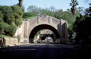
The Figueroa Street Tunnels are a set of four four-lane tunnels that carry northbound traffic on State Route 110 through Elysian Park in Los Angeles, California, United States. From south to north, the four tunnels measure 755, 461, 130, and 405 feet in length, 46.5 feet in width, and 28.3 ft in height.

State Route 47 is a state highway in the U.S. state of California, connecting Terminal Island to the mainland in the Los Angeles area. From its south end at I-110 in San Pedro, it heads east across the Vincent Thomas Bridge to the island and the end of state maintenance. The state highway begins again at the junction with I-710 on Terminal Island, crossing the Schuyler Heim Bridge north to the mainland and the second terminus, where SR 103 begins. Signage continues along a locally maintained route, mainly Alameda Street, to the Gardena Freeway in Compton, and an unconstructed alignment follows the same corridor to the Santa Monica Freeway (I-10) near downtown Los Angeles.

Figueroa Street is a major north-south street in Los Angeles County, California, spanning from the Los Angeles neighborhood of Wilmington north to Eagle Rock. A short, unconnected continuation of Figueroa Street runs just south of Marengo Drive in Glendale to Chevy Chase Drive in La Cañada Flintridge.

May Company California was an American chain of department stores operating in Southern California and Nevada, with headquarters at its flagship Downtown Los Angeles store until 1983 when it moved them to North Hollywood. It was a subsidiary of May Department Stores and merged with May's other Southern California subsidiary, J. W. Robinson's, in 1993 to form Robinsons-May.
Fort Moore was the second of two historic U.S. Military Forts in Los Angeles, California, during the Mexican–American War. It lay straight above the junction of the Hollywood Freeway and Broadway, on an historic hill that once sheltered the old Plaza.

Interstate 5 (I-5) is a major north–south route of the Interstate Highway System in the United States, running largely parallel to the Pacific Coast between the Mexican border and the Canadian border. The segment of I-5 in California runs across the length of the state from the Mexican border at the San Ysidro Port of Entry in the San Ysidro neighborhood of San Diego to the Oregon state line south of the Medford-Ashland metropolitan area. It is the longest interstate in California at 796.77 miles (1,282.28 km), and accounts for more than half of I-5's total length of 1,381.29 miles (2,222.97 km). It is also the second longest stretch of Interstate Highway with a single designation within a single state after I-10 in Texas.

Yerba Buena Cove was a cove on San Francisco Bay where the Mexican town of Yerba Buena was located. It lay between Clarks Point to the north and Rincon Point to the south. The beach of the cove was set as far back as what is now Montgomery Street between Clay and Washington Streets.
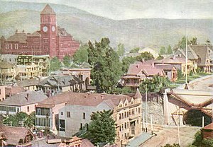
The late-Victorian-era Downtown of Los Angeles in 1880 was centered at the southern end of the Los Angeles Plaza area, and over the next two decades, it extended south and west along Main Street, Spring Street, and Broadway towards Third Street. Most of the 19th-century buildings no longer exist, surviving only in the Plaza area or south of Second Street. The rest were demolished to make way for the Civic Center district with City Hall, numerous courthouses, and other municipal, county, state and federal buildings, and Times Mirror Square. This article covers that area, between the Plaza, 3rd St., Los Angeles St., and Broadway, during the period 1880 through the period of demolition (1920s–1950s).

7th Street is a street in Los Angeles, California running from S. Norton Ave in Mid-Wilshire through Downtown Los Angeles. It goes all the way to the eastern city limits at Indiana Ave., and the border between Boyle Heights, Los Angeles and East Los Angeles.