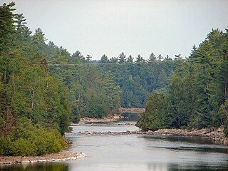
The Kipawa River is a short river in western Quebec, Canada. It is mostly an undeveloped river but the larger lakes have dams, fishing camps, and cottages on their shores. The communities of Kipawa and Laniel are located on Lake Kipawa. Also much logging takes place within its watershed basin, which is consequently crisscrossed by many bush roads. Route 101 crosses the river at Laniel.

Gaspésie National Park is a provincial park located south of the town of Sainte-Anne-des-Monts, Quebec, Canada in the inland of the Gaspé peninsula. The park contains the highest peak of the Appalachian Mountains in Canada, Mont Jacques-Cartier, 1,270 metres (4,170 ft) above sea level. In addition, the park contains the only population of Caribou found south of the Saint Lawrence River in Canada.

Jacques-Cartier National Park is a provincial park located 50 kilometres (31 mi) north of Quebec City. The park aims to protect wildlife in the Laurentian massif. It lies within the Eastern forest-boreal transition ecoregion.

Aiguebelle National Park(French: Parc national d'Aiguebelle) is a provincial park in Quebec, Canada. It is located in western Quebec in the Abitibi-Témiscamingue region some 50 km north-east of Rouyn-Noranda, 50 km west of Amos, Quebec, 100 km north west of Val-d'Or, Quebec, and about 50 km due west of Lake Hebecourt. The park has a surface area of 268,3 km2.
Bic National Park is an 33.2-square-kilometre (8,200-acre) national park of Quebec, Canada, located on the south shore of the St. Lawrence River, near the villages of Le Bic and Saint-Fabien, southwest of Rimouski. It was founded on October 17, 1984, and is home to large populations of harbour seals and grey seals. Its highest point is Pic Champlain at 346 metres (1,135 ft). Slightly less than half of the park is a coastal marine environment.
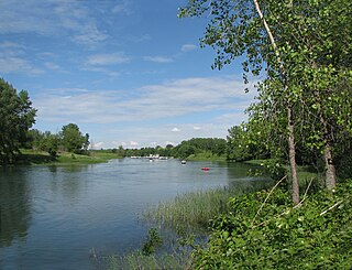
The Îles-de-Boucherville National Park is a provincial park along the Saint Lawrence river in the province of Quebec.

Mont-Orford National Park is a national park in Orford, Quebec, Canada that is maintained and protected by the Sépaq. a provincial body.

Pointe-Taillon National Park(Parc national de la Pointe-Taillon) is a provincial park in Quebec, Canada. It is located on the north shore of Lac Saint-Jean, northwest of Saguenay (city), northwest of Alma, near the village of Saint-Henri-de-Taillon, on the banks of Lac Saint-Jean. The park covers an area of 97.5 km (60.58 mi) has as a 45 km (28 mi) cycling network.

Saguenay Fjord National Park is a provincial park located in Quebec, Canada. In the regions of Saguenay–Lac-Saint-Jean, Charlevoix, Côte-Nord, and Bas-Saint-Laurent, the park is situated along the eastern end of the Saguenay River and adjoins the Saguenay–St. Lawrence Marine Park for over 100 km (60 mi.).

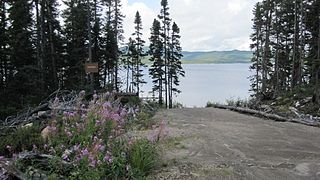
Lake Walker is a lake in Quebec, Canada. It is located in the Sept-Rivières Regional County Municipality in the region of Côte-Nord, about 30 km northwest of Port-Cartier.
The Lake Masketsi is located in the unorganized territory of Lac-Masketsi, in the Mekinac Regional County Municipality, in Mauricie, in Quebec, in Canada.

Lac-Témiscouata National Park is a provincial park located in Quebec, Canada south of the Saint Lawrence River, near the border with New Brunswick. It contains Lake Témiscouata, which is "the second-largest lake south of the Saint Lawrence River" within some unspecified area, perhaps within Quebec, with a length of around 40 km (25 mi). Touladi River can also be found within the park's boundaries.

The MacDonald River is a river in Quebec, Canada, to the north of the lower Saint Lawrence River. It is known for its dramatic cascade, the Chute MacDonald.
The Schmon River is a river in the Côte-Nord region of the province of Quebec, Canada. It flows south into Lake Walker.
The Pasteur River is a river in Quebec, Canada, to the north of the lower Saint Lawrence River. It is a tributary of the Aux Rochers River in the Lac-Walker territory of Côte-Nord. For most of its length it flows through the proposed Lake Walker National Park. The lower section of the river includes the 21 kilometres (13 mi) long Lake Pasteur.
The Gravel River is a river in Quebec, Canada, to the north of the lower St. Lawrence River. It is a tributary of the Aux Rochers River in the Lac-Walker territory of Côte-Nord.
Lake Cacaoui is a lake in the Côte-Nord region of Quebec, Canada. It drains into the Sainte-Marguerite River.

LakeStukely is a 4 square kilometres (1.5 sq mi) natural lake located in the Eastern region of Quebec, Canada. Its waters border the municipalities of Orford, Bonsecours, Eastman and a large part of Mount Orford National Park. It lies at the head of the Saumon River watershed, giving it a fairly long retention time for its size.

Montagne du Fourneau is a mountain in the Lac-Témiscouata National Park in Quebec, Canada. It owes its name to the fact that during the first half of the 19th century, the mountain's limestone deposits were used to fuel a lime kiln at Fort Ingall. It was then used as forest land by the owners of the Madawaska Seignory. The unconceded lands of the seigneury were acquired by the Quebec government in 1969.


