Related Research Articles

The Mount Hood Corridor is a part of Oregon between Sandy and Government Camp, in Clackamas County. It is named after Mount Hood and has served travelers going in both directions since the days of Native Americans and Oregon Trail migrants. The area between Alder Creek and Government Camp is sometimes known as Hoodland.

The Hawthorne District in Portland, Oregon, is an area of Southeast Portland on SE Hawthorne Blvd. that runs from 12th to 60th Avenues, with the primary core of businesses between 30th and 50th Avenues. The area has numerous retail stores, including clothing shops, restaurants, bars, brewpubs, and microbreweries.
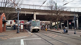
Rose Quarter Transit Center is a light rail station in the MAX system and a TriMet bus transit center, and is located in the Rose Quarter area of Portland, Oregon, a part of the Lloyd District. It is served by the Blue, Green and Red Lines. It is currently the 7th stop eastbound on the Eastside MAX as well as the first stop after crossing the Willamette River on the Steel Bridge. Two hundred yards west of the station is the Interstate/Rose Quarter station on the MAX Yellow Line.

Shepperd's Dell is a small canyon in the Columbia River Gorge in Oregon, located at 45.54833°N 122.195°W which is less than one-third mile southeast of Rooster Rock State Park. The Shepperd's Dell Bridge is listed on the National Register of Historic Places.
Progress, Oregon is a neighborhood in Washington County, Oregon, United States. Originally an unincorporated community that stood apart from any city, most of Progress now lies within the city limits of either Tigard or Beaverton. Other nearby communities include Garden Home and Metzger.
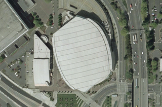
The Rose Quarter is a 30-acre (12-hectare) sports and entertainment district located in Portland's Lloyd District on the east bank of the Willamette River, just east of downtown. The Rose Quarter is bounded on the west by NE Interstate Avenue, on the north by NE Broadway and NE Weidler Streets, on the east by Interstate 5, and on the south by NE Holladay Street. The site contains two multipurpose arenas, the Moda Center and the Memorial Coliseum. Nearby landmarks include the Steel and Broadway bridges, the Oregon Convention Center, and the Eastbank Esplanade.

Oregon's 3rd congressional district covers most of Multnomah County, including Gresham, Troutdale, and most of Portland east of the Willamette River. It also includes the northeastern part of Clackamas County and all of Hood River County. Generally, most of Portland east of the Willamette River is in the 3rd District.
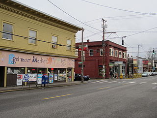
The Belmont Area is a retail and residential district running along SE Belmont St. in the inner Southeast section of Portland, Oregon in a parallel fashion to the Hawthorne District, 6 blocks to the south. From west to east the area extends 48 blocks, from SE 12th Ave. to SE 60th Ave., passing through the Buckman, Sunnyside, and Mount Tabor neighborhoods. The area is seven blocks wide, running from SE Belmont St. 4 blocks north to SE Stark St. and 3 blocks south to SE Salmon St. SE Belmont St. between SE 33rd Ave. and SE 35th Ave., in Sunnyside, is the heart of the district.

The Oregon Sports Hall of Fame honors Oregon athletes, teams, coaches, and others who have made a significant contribution to sports in Oregon. The first class was inducted in 1980, with new inductees added in the fall. Operated by the Oregon Sports Trust, the museum is currently closed in preparation for moving to another facility.

The Seattle-Tacoma Shipbuilding Corporation was an American corporation which built escort carriers, destroyers, cargo ships and auxiliaries for the United States Navy and merchant marine during World War II in two yards in Puget Sound, Washington. It was the largest producer of destroyers (45) on the West Coast and the largest producer of escort carriers of various classes (56) of any United States yard active during World War II.

Cascade Station is a mixed-use development of a shopping center, office buildings, and hotels located in Northeast Portland, Oregon along Airport Way and I-205, near Portland International Airport. It features 1,325,000 square feet (123,100 m2) of office space, 1,200 hotel rooms and 400,000 square feet (37,000 m2) of retail space, on 120-acre (0.49 km2) land.

Midway is an unincorporated rural community in Washington County, Oregon, United States. It is located on Oregon Route 219 about 2.5 miles (4.0 km) west of Scholls. The area is the halfway point between Hillsboro to the north and Sherwood to the southeast, thus it became known as Midway. Midway has a large plant nursery business, a bar and grill and a rural fire station for Washington County Fire District 2.

Blue Lake Regional Park is a public park in Fairview, in the U.S. state of Oregon. The 101-acre (41 ha) park, near the south shore of the Columbia River in Multnomah County, includes many covered and uncovered picnic areas, playing fields for sports such as softball, a cross country course and infrastructure related to lake recreation including swimming, boating, and fishing. Encompassing wooded areas, three ponds, and a wetland in addition to the lake, the park is frequented by migrating birds and other wildlife. Paved paths run through the park, which is near the 40-Mile Loop hiking and biking trail. Park vegetation includes cottonwoods, willows, and other trees and shrubs as well as wetland plants such as cattails.

RiverPlace is a mixed-use district of Downtown Portland, Oregon. Although not an officially recognized neighborhood, its borders can be considered to be Naito Parkway to the west, the Willamette River to the east, and the Marquam Bridge to the south. The area was brownfield land before it was developed.

The Oregonian Printing Press Park, or simply Printing Press Park, is a triangular 1,000-square-foot park on the southeastern corner of the intersection of Southwest First Avenue and Morrison Street in Portland, Oregon, United States. The green space marks where editor Thomas J. Dryer operated a small press to publish Portland's weekly newspaper, which would become The Oregonian, beginning on December 4, 1850.
Clackamas Education Service District is an education service district that coordinates school events and activities throughout the school districts in Clackamas County, Oregon. Clackamas ESD serves the educational needs of students and families in Clackamas County – a geographic area of 1,879 square miles.

Prism Health is a health clinic located on Southeast Belmont Street, in Portland, Oregon's Buckman neighborhood, in the United States. Prism became Oregon's first LGBT primary health clinic in 2017, and opened as an extension of the Cascade AIDS Project.
Swindells Hall is an academic building on the University of Portland campus in Portland, Oregon, United States. The 41,000 square-foot building was built in 1999.

Northeast Portland is one of the six major divisions of Portland, Oregon.
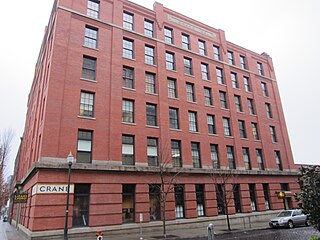
The Crane Building is an historic building in Portland, Oregon. Completed in 1909, the structure is part of the Portland Thirteenth Avenue Historic District, which is listed on the National Register of Historic Places.
References
- ↑ Njus, Elliot (March 5, 2015). "Oregon Square redevelopment to bring enormous public plaza to the Lloyd District (images)". OregonLive.com. Retrieved 2018-05-16.
| Buildings | |
|---|---|
| Business | |
| Geography | |
| Public art | |
| Transportation | |
45°31′46″N122°39′27″W / 45.52933°N 122.65760°W
| | This Multnomah County, Oregon state location article is a stub. You can help Wikipedia by expanding it. |