
The Western Ghats, also known as Sahyadri, are a mountain range that covers an area of 140,000 square kilometres (54,000 sq mi) in a stretch of 1,600 kilometres (990 mi) parallel to the western coast of the Indian peninsula, traversing the states of Kerala, Tamil Nadu, Karnataka, Goa, Maharashtra and Gujarat. It is a UNESCO World Heritage Site and is one of the eight "hottest hot-spots" of biological diversity in the world. It is sometimes called the Great Escarpment of India. It contains a large proportion of the country's flora and fauna, many of which are only found in India and nowhere else in the world. According to UNESCO, the Western Ghats are older than the Himalayas. They influence Indian monsoon weather patterns by intercepting the rain-laden monsoon winds that sweep in from the south-west during late summer. The range runs north to south along the western edge of the Deccan Plateau, and separates the plateau from a narrow coastal plain, called Konkan, along the Arabian Sea. A total of thirty-nine areas in the Western Ghats, including national parks, wildlife sanctuaries and reserve forests, were designated as world heritage sites in 2012 – twenty in Kerala, ten in Karnataka, five in Tamil Nadu and four in Maharashtra.
Malabar region refers to the historic and geographic area of southwest India, covering the districts of Kerala Kozhikode, Wayanad, kannur and Kasaragod. It lies between the Western Ghats and the Arabian sea.

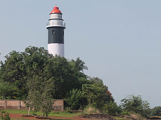
Uttara Kannada, formerly known as North Canara, is a district in the Indian state of Karnataka. It is bordered by the state of Goa and Belagavi District to the north, Dharwad District and Haveri District to the east, Shivamogga District, and Udupi District to the south, and the Arabian Sea to the west. The city of Karwar is the administrative headquarters of the district. Bhatkal, Sirsi, and Dandeli are other major towns in the district.

Konkan, also known as the Konkan Coast, is a rugged section of the western coastline of India. In Marathi it is called as kōkan (कोकण), in Konkani as kōñkan (कोंकण), and the Kannada word karāvalli (ಕರಾವಳಿ/करावळी), literally meaning 'coast', is generally applied to the Kanara subregion.

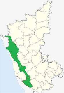
Kanara is a stretch of land alongside the Arabian Sea in the Indian state of Karnataka. The region comprises three civil districts, namely: Uttara Kannada, Udupi, and Dakshina Kannada.
Malenadu is a region in the state of Karnataka in India. Malenadu covers the western and eastern slopes of the Western Ghats or Sahyadri mountain range, and is roughly 100 kilometers in width. It is situated between Coastal Karnataka and Bayaluseeme regions of Karnataka. Shivamogga, Karnataka is known as Gate of Malenadu or Malenadina Hebbagilu in Kannada.
The Malabar Coast moist forests is a tropical moist broadleaf forest of southwestern India. It lies along India's Konkan and Malabar coasts, in a narrow strip between the Arabian Sea and the Western Ghats range, which runs parallel to the coast. It has an area of 35,500 square kilometers (13,700 sq mi), and extends from northern Maharashtra through Goa, Karnataka and Kerala to Kanniyakumari in southernmost Tamil Nadu.
The North Western Ghats moist deciduous forests is a tropical moist broadleaf forest ecoregion of southwestern India.

Ghat, a term used in the Indian subcontinent, depending on the context could refer either to a range of stepped-hills with valleys, such as the Eastern Ghats and Western Ghats; or the series of steps leading down to a body of water or wharf, such as a bathing or cremation place along the banks of a river or pond, the Ghats in Varanasi, Dhoby Ghaut or the Aapravasi Ghat. Roads passing through ghats are called Ghat Roads.

Thirthahalli is a panchayat town located in the Shivamoga District of the state of Karnataka, India. It lies on the bank of the river Tunga and is also the headquarters of the Thirthahalli Taluk of Shimoga district. Nearest Railway stations are Anandpura, Shivamogga and Bhadravathi. The nearest airport is at Mangalore.

The Indian State of Karnataka is located 11°30' North and 18°30' North latitudes and 74° East and 78°30' East longitude. It is situated on a tableland where the Western and Eastern Ghat ranges converge into the complex, in the western part of the Deccan Peninsular region of India. The State is bounded by Maharashtra and Goa States in the north and northwest; by the Arabian Sea in the west; by Kerala and Tamil Nadu States in the south and by the States of Andhra Pradesh and Telangana in the east. Karnataka extends to about 750 km from north to south and about 400 km from east to west.
The Western Coastal Plains is a strip of coastal plain 50 kilometres (31 mi) in width between the west coast of India and the Western Ghats hills, which starts near the south of the Tapti River. The plains are located between the Western Ghats and the Arabian Sea. The plains begin at Gujarat in the north and end at Kerala in the south. It includes the states of Maharashtra, Goa, Karnataka and Kerala. The region consists of three sections: the Northern part of the coast is called the Konkan (Mumbai-Goa), the central stretch is called the Kanara or the "Karavali", while the southern stretch is referred to as the Malabar Coast. On its northern side there are two gulfs: the Gulf of Khambat and the Gulf of Kutch. The rivers along the coast form estuaries and provide conditions ideal for pisciculture. because of the presence of less coastal land in this part, it will be affected more by the global warming.

The Geography of South India comprises the diverse topological and climatic patterns of South India. South India is a peninsula in the shape of a vast inverted triangle, bounded on the west by the Arabian Sea, on the east by the Bay of Bengal and on the north by the Vindhya and Satpura ranges. Technically all Indian territories below the 20th Parallel.
Sahyadri Tiger Reserve is a reserve in the state of Maharashtra. It was created by the Indian government in 2008. The Sahyadri Tiger Reserve is located in the Sahyadri Ranges of the Western Ghats of Maharashtra, and is a part of the ecoregions of North Western Ghats moist deciduous forests and North Western Ghats montane rain forests. These ranges form a common boundary between Maharashtra, Karnataka and Goa, and constitute rich evergreen, semi-evergreen and moist deciduous forests. The area is spread over four districts, namely Satara, Sangli, Kolhapur and Ratnagiri.

Perunthenaruvi Waterfalls are waterfalls 36 km (22 mi) from Pathanamthitta in Pathanamthitta District, Central Travancore region, Kerala State, India. It is a popular tourist destination situated in Vechoochira Panchayat of Ranni taluk. The one shore of this waterfall is Kudamurutty and Vechoochira is the other. The main route to this waterfall starts from Ranni - Athikkayam - Kudamurutty - Perunthenaruvi. It is a fine place to spend time with family in a very serene atmosphere.
Vajrapoha Falls, a waterfall in the Belgaum district of Karnataka in India, is situated about in the mountainous forest 8.5 kilometres (5.3 mi) in south west direction from the village of Jamboti. Between the village of Gavali and Chapoli on an elevated hillock, the Mandovi River that flows to the beautiful Vajrapoha Falls that fall for up to 200 metres (660 ft) and are best seen after the monsoon season (June–October). The falls are about 1.5 hours southwest of Belgaum.

Chorla Ghat is a nature destination located on the intersection of the borders of Goa, Karnataka and Maharashtra. It lies to the north-east of Panaji, Goa and nearly 55 kilometers from Belgaum, Karnataka. It is a part of the Western Ghats in the Sahyadri mountain range and is at an elevation of 800 meters. Chorla ghat boasts of a few rare species of wild-life such as the barred wolf snake in its sub-tropical forests.

National Highway 766 is a National Highway in Southern India. NH 766 connects Kozhikode in Kerala with Kollegal in Karnataka via Mysore. Of the total distance of 272 km, 117 km is in Kerala and 155 is in Karnataka. At Kollegal, it joins National Highway 948, which connects Bengaluru and Coimbatore. The highway passes through dense forests of Western ghats of India. The NH-766 passes through 19.7 KM Bandipur National Park and Wayanad wild life sanctuary.
Biogeographic classification of India is the division of India according to biogeographic characteristics. Biogeography is the study of the distribution of species (biology), organisms, and ecosystems in geographic space and through geological time. There are ten biogeographic zones in India.
- Trans Himalayan zone.
- Himalayan zone
- Desert zone.
- Semiarid zone.
- Western ghat zone.
- Deccan plateau zone.
- Gangetic plain zone.
- North east zone.
- Coastal zone.
- Islands
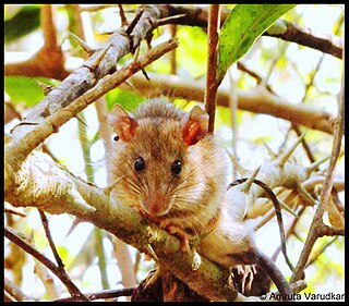
The Sahyadris forest rat is a species of rat belonging to the family Muridae. It is native to the northern Western Ghats in India where it is split between three regions, Satara in Maharashtra, the Nilgiri mountains in Tamil Nadu and Kodagu district in Karnataka.

