Orr Branch

Last updated
Orr Branch
WhiteRk147-016.jpg
An undeveloped stretch of the northern tributary of Orr Branch.
Relief map of Texas.png
Red pog.svg
Location of mouth
Location
Country United States
State Texas
County Dallas
Physical characteristics
Source 
  coordinates 32°54′02″N96°47′44″W / 32.9005556°N 96.7955556°W / 32.9005556; -96.7955556
Mouth  
  coordinates
32°54′42″N96°46′36″W / 32.9116667°N 96.7766667°W / 32.9116667; -96.7766667
Length2 mi (3.2 km) [1]

Orr Branch is a roughly 2-mile (3.22 km) creek in the White Rock/Trinity River watershed in eastern Texas. From its uppermost source near the intersection of Tibbs and West Ricks Circle streets, it runs northeast through a portion of suburban Dallas until it flows into White Rock Creek (of which it is a tributary) and ultimately feeds into White Rock Lake. [2]

Contents

History

From the end of the Pleistocene Epoch and into historic times, the Texas blackland prairie surrounding Orr Branch supported scattered herds of bison and (prior to European contact) the Indian tribes who utilized bison as a resource. In north central Texas, these tribes would have included the Kitikiti'sh (Wichita), Comanche, Caddo, and Cherokee. [3]

By the mid-19th Century, cattle and other livestock had replaced the bison. Prairie grasses and forbs were vital forage for Texas Longhorns and other breeds being moved north along the ancient trace that came to be known as Preston Trail, the present-day Preston Road. This route was desirable in part because it traveled along the spine of a limestone ridge, or “cuesta” that separated the eastern and western zones of the Black Lands.

Overgrazing eventually depleted the value of these lands for livestock forage. With the invention of plows capable of breaking through the “black waxy” soil of the region, the prairie sod was turned and European-style farming came to the area. As geologist Robert T. Hill pointed out in 1901, “Large quantities of cotton, corn, and minor crops are annually raised upon these fertile lands.” [4] Prairie not plowed for crops was mowed for hay, and a few of these old hayfields still stand open to the North Texas sun. Similarly, a scattering of farmhouses built in the late 19th and early 20th centuries can still be found at historic sites in Dallas and smaller cities across the area.

Deep cultivation, cotton farming and drought were not kind to the blackland soil, and by the mid-20th Century farm tracts began to be sold for other development. In 1947, a developed named Rick Strong purchased several parcels of land surrounding a major portion of Orr Branch, a City of Dallas addition that was incorporated as “Hillcrest Estates”. Centered on a roughly mile-long stretch of Northaven Road, these parcels of old pasture and farm structures were subdivided, typically into 300-foot-deep lots, some with horse corrals, and the neighborhood association's building restrictions required homes to be a minimum of 2,300 square feet. Landscaping on these semi-rural lots often involved adapting the native plant species.

By the end if the 20th Century, the land around Orr Branch had undergone its most drastic transformation since the demise of the bison and the arrival of the plow. Rampant real estate speculation throughout Texas had drastically inflated North Dallas land values, and what had been middle class homes were being acquired, demolished and replaced with opulent mansions. Home lots were re-landscaped wholesale and many of the native plants removed. At this point in time, the principle remnants of the original Blackland Prairie setting of the area are its riparian corridors, such as Orr Branch.

Course

Water flowing in the main channel of Orr Branch travels northeast from the Hillcrest Estates/Northaven Road area to enter the mainstream of White Rock Creek at 32°54'42.0"N 96°46'35.0”W, a point just north of Forest Lane, south of present day Bonner Park and west of North Central Expressway/US Highway 75. There are two tributaries of Orr Branch to the north of the mainstream, the western-most of these originating at a point about one half mile north of the intersection of Forest Lane and Preston Road. Water in this tributary flows through a series of small impoundments, under Forest Lane and merges with the main stream at the point where Orr Branch flows east under Hillcrest Road.

Watershed

Orr Branch drains an area just over 2 square miles, [5] the western portions of which are virtually flat. Elevation change through the stream channel runs from 600 feet above sea level at the outer rim of the stream's cuts to roughly 500 feet at the main channel of White Rock Creek. Weather conditions within this area correspond generally to statistics for the climate of Dallas as a whole.

With any powerful thunderstorm, turbulent water will rapidly fill the channels of Orr Branch. Major floods affected the White Rock Creek watershed in 1962 and 1964. [6] On those occasions, the area inundated in places extended up to a quarter mile from the main channel of the Creek, but was very limited along most of Orr Branch, suggesting a high rate of flow in this tributary during such floods. Since the 1950s, the flat lands west of the stream have been dominated by paved suburban streets and adjacent homesites, suggesting a significant quantity of chemical and particulate water pollutants (e.g. motor oil, lawn fertilizers, pesticides, animal waste, tire rubber and brake dust) is carried into the channel by stormwater runoff. Invariably, this would lead to enhanced eutrophication in aquatic habitats and heightened environmental stress for resident plants and animals.

Stream modifications

A major limiting factor for farming the Blackland Prairie was the availability of water. Tributary streams like Orr Branch would often run dry during unusually hot summers or lengthy droughts. Dams and stock tanks were constructed to retain surface water, and as R. T. Hill noted “for domestic purposes [prairie] inhabitants depend largely upon cisterns or ponds, the water from both of which is unwholesome”. [7] With road improvements and annexation of the area by the City of Dallas, home sites were connected to municipal water and sewage networks, and the Orr Branch watershed was incorporated into the municipal storm water control network, and additional bridges and under-street culverts were installed. In the portion of Hillcrest Estates south of Northaven Road, a small chain of such water impoundments lies along Orr Branch, some of these descended from old stock tanks used by the precursor farms. Over time, dams on these ponds have been heightened, and bridges and retaining walls constructed, for increased depth, erosion control or enhanced aesthetics.

Natural history /Wildlife / Biology

English naturalist Thomas Nuttall (1766-1859) was among the first trained botanists to describe the North American Great plains plant communities. On a journey west out of Fort Smith, Arkansas Territory in 1819, Nuttall encountered a portion of the Black Lands where they extend just north of the Red River (east of present day Durant, Oklahoma). There he noted many of the woody and herbaceous plant species still associated with prairie country. [8]

Combining rich topsoils with an extensive network of riparian corridors, the prairies of North Central Texas host over 2000 species of plants (roughly 46 per cent of all plants species recorded for Texas). [9] When one includes invertebrates, birds (migratory and resident species), mammals and other vertebrates, the Blackland Praririe comprises perhaps the most diverse biota of all the central North American prairies. [10] For a current compilation of plants and animals observed in and around Orr Branch consult the citizen science observations assembled by INaturalist at [https://www.inaturalist.org/places/148563.

Geology

The native topography of the Orr Branch area consists of flat to gently-rolling prairie broken by downward-cutting stream channels. Continuous exposures of bedrock are common only in the stream beds and lower areas of the stream embankments. Above these locations, the area's bedrock is covered at variable depths by characteristic Blackland Prairie soil. In his 1901 monograph on the "Black Land and Grand Prairies" of North Texas, R. T. Hill describes how the largest extent of these black lands is divided roughly north to south by a ridge of limestone, a feature for which he cited the local names "White Rock" and "Austin Chalk". In several locations from southern Dallas County and on south to Austin, Texas, this limestone emerges from the prairies in a prominent scarp, or escarpment. In north Dallas, however, this feature is much more subtle, yet as elsewhere it presents a west-facing fault exposure, accompanied by a gentle slope eastward, thus forming a cuesta. Hill points out that while the major water courses of this region flow southeastward, toward the Gulf of Mexico, tributaries near the Austin Chalk escarpment tend to be somewhat perpendicular to the larger channels and parallel to the escarpment, thus explaining the northeasterly trend of Orr Branch.

Bedrock west of the escarpment consists of the dark Eagle Ford shale, the parent rock for the prairie's most viscous soil textures. In the days of widespread cultivation along Preston Trail, these Eagle Ford Prairie soils were conspicuous. The east slope of the cuesta, with shallower soil of a brighter texture and color, Hill dubbed the White Rock Prairie. The Austin limestone exposed in the beds of the Orr Branch stream channels is marine in origin and of Cretaceous age, [11] and while not generally fossiliferous will occasionally produce the preserved remains of Inoceramus clams, ammonites, and large vertebrates such as Xiphactinus, a predaceous fish.

Related Research Articles

<span class="mw-page-title-main">Prairie</span> Ecosystems considered part of the temperate grasslands, savannas, and shrublands biome

Prairies are ecosystems considered part of the temperate grasslands, savannas, and shrublands biome by ecologists, based on similar temperate climates, moderate rainfall, and a composition of grasses, herbs, and shrubs, rather than trees, as the dominant vegetation type. Temperate grassland regions include the Pampas of Argentina, Brazil and Uruguay, and the steppe of Ukraine, Russia and Kazakhstan. Lands typically referred to as "prairie" tend to be in North America. The term encompasses the area referred to as the Interior Lowlands of Canada, the United States, and Mexico, which includes all of the Great Plains as well as the wetter, hillier land to the east.

<span class="mw-page-title-main">Tallgrass prairie</span> Ecosystem native to central North America

The tallgrass prairie is an ecosystem native to central North America. Historically, natural and anthropogenic fire, as well as grazing by large mammals provided periodic disturbances to these ecosystems, limiting the encroachment of trees, recycling soil nutrients, and facilitating seed dispersal and germination. Prior to widespread use of the steel plow, which enabled large scale conversion to agricultural land use, tallgrass prairies extended throughout the American Midwest and smaller portions of southern central Canada, from the transitional ecotones out of eastern North American forests, west to a climatic threshold based on precipitation and soils, to the southern reaches of the Flint Hills in Oklahoma, to a transition into forest in Manitoba.

<span class="mw-page-title-main">Gulf Coastal Plain</span> Coastal Plain in the Southern United States and Eastern Mexico

The Gulf Coastal Plain extends around the Gulf of Mexico in the Southern United States and eastern Mexico.

<span class="mw-page-title-main">White Rock Creek</span>

White Rock Creek is a 30 miles (48 km) creek occupying a chain of four sub-watersheds within the Trinity River watershed. From its source near Frisco, Texas at 33°07′54″N96°46′50″W, this creek runs south-by-south-east through suburban Dallas for 23.5 miles (37.8 km) where it widens into White Rock Lake, then continues south for another 8 miles (13 km) to its mouth on the Trinity River, of which it is a major tributary.

<span class="mw-page-title-main">Pawnee National Grassland</span> Area of protected federal lands in northeastern Colorado

Pawnee National Grassland is a United States National Grassland located in northeastern Colorado on the Colorado Eastern Plains. The grassland is located in the South Platte River basin in remote northern and extreme northeastern Weld County between Greeley and Sterling. It comprises two parcels totaling 193,060 acres (78,130 ha) largely between State Highway 14 and the Wyoming border. The larger eastern parcel lies adjacent to the borders of both Nebraska and Wyoming. It is administered in conjunction with the Arapaho-Roosevelt National Forest from the U.S. Forest Service office in Fort Collins, with a local ranger district office in Greeley.

<span class="mw-page-title-main">Texas Blackland Prairies</span> Temperate grassland region of Texas, US

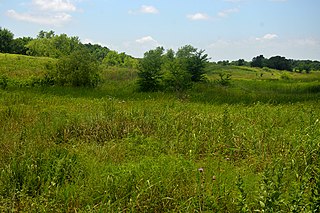
The Texas Blackland Prairies are a temperate grassland ecoregion located in Texas that runs roughly 300 miles (480 km) from the Red River in North Texas to San Antonio in the south. The prairie was named after its rich, dark soil. Less than 1% of the original Blackland prairie vegetation remains, scattered across Texas in parcels.

<span class="mw-page-title-main">Headward erosion</span> The Geographical processes of the Earth

Headward erosion is erosion at the origin of a stream channel, which causes the origin to move back away from the direction of the stream flow, lengthening the stream channel. It can also refer to the widening of a canyon by erosion along its very top edge, when sheets of water first enter the canyon from a more roughly planar surface above it, such as at Canyonlands National Park in Utah. When sheets of water on a roughly planar surface first enter a depression in it, this erodes the top edge of the depression. The stream is forced to grow longer at the very top of the stream, which moves its origin back, or causes the canyon formed by the stream to grow wider as the process repeats. Widening of the canyon by erosion inside the canyon, below the canyon side top edge, or origin or the stream, such as erosion caused by the streamflow inside it, is not called headward erosion.

<span class="mw-page-title-main">Geography of Texas</span> Geographical features of Texas

The geography of Texas is diverse and large. Occupying about 7% of the total water and land area of the U.S., it is the second largest state after Alaska, and is the southernmost part of the Great Plains, which end in the south against the folded Sierra Madre Oriental of Mexico. Texas is in the South Central United States of America, and is considered to form part of the U.S. South and also part of the U.S. Southwest.

<span class="mw-page-title-main">Chillisquaque Creek</span> River

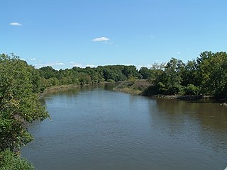
Chillisquaque Creek is a tributary of the West Branch Susquehanna River in Montour County and Northumberland County, in Pennsylvania, in the United States. It is approximately 20.2 miles (32.5 km) long and flows through Derry Township, Washingtonville, and Liberty Township in Montour County and East Chillisquaque Township and West Chillisquaque Township in Northumberland County. The watershed of the creek has an area of 112 square miles (290 km2). Agricultural impacts have caused most of the streams in the watershed of the creek to be impaired. Causes of impairment include sedimentation/siltation and habitat alteration. The average annual discharge of the creek between 1980 and 2014 ranged from 48.2 to 146.0 cubic feet per second. Its watershed mainly consists of rolling agricultural land. The creek's channel flows through rock formations consisting of sandstone and shale. It is a warmwater stream.

<span class="mw-page-title-main">Fishing Creek (North Branch Susquehanna River tributary)</span> Tributary of river in Pennsylvania

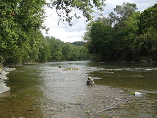
Fishing Creek is a 29.98-mile (48.25 km) long tributary of the Susquehanna River in Columbia County, Pennsylvania, in the United States. It joins the Susquehanna River near the census-designated place of Rupert and the town of Bloomsburg. The watershed has an area of 385 square miles (1,000 km2).

<span class="mw-page-title-main">Pawnee Buttes</span>

The Pawnee Buttes are two prominent buttes in northeastern Colorado. The west butte is located within the Pawnee National Grassland, while the east butte is on private land in Weld County. Rising approximately 300 feet (91 m) above the surrounding plains, the buttes are erosional remnants left standing in isolation as the surrounding High Plains surface has gradually worn away. The lower portions of the buttes are composed of relatively soft, clay-rich sedimentary rock called the Brule formation. The Brule formation is protected by an overlying layer of sandstone and conglomerate sediments called the Arikaree formation, which are more resistant to weathering.

<span class="mw-page-title-main">Big Timber Creek</span> River in New Jersey, United States

Big Timber Creek is a 5.6-mile-long (9.0 km) stream in southwestern New Jersey. The creek was called Tetamekanchz Kyl by Lenape tribes prior to European settlement in the area. The creek drains a watershed of 63 square miles (160 km2) and is a tributary of the Delaware River.

<span class="mw-page-title-main">Scott's Gulf</span> Canyon in Tennessee

Scott's Gulf is a canyon situated along the Caney Fork River in White County, Tennessee, in the southeastern United States. The canyon stretches for approximately 18 miles (29 km) as the Caney Fork drops from the top of the Cumberland Plateau down to the eastern Highland Rim. This remote section of the river is home to a wilderness area consisting of a largely undisturbed deciduous forest, numerous waterfalls, caves and other geological formations, and Class IV and Class V whitewater rapids.

<span class="mw-page-title-main">East Central Texas forests</span> Temperate broadleaf and mixed forests ecoregion of Oklahoma and Texas, United States

The East Central Texas forests or East Central Texas Plains (33) is a small temperate broadleaf and mixed forests ecoregion almost entirely within the state of Texas, United States. The northern forests perimeter is partially within the southeast Oklahoma border.

<span class="mw-page-title-main">East Branch Fishing Creek</span> River

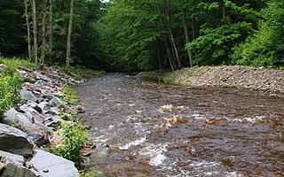
East Branch Fishing Creek is a tributary of Fishing Creek in Columbia County and Sullivan County, Pennsylvania, in the United States. It is 4.4 miles (7.1 km) long. The stream and its tributaries are acidic and contain aluminum. The area in the vicinity was first settled in the late 18th century.

<span class="mw-page-title-main">Blackberry Run</span> River

Blackberry Run is a tributary of East Branch Fishing Creek in Sullivan County, Pennsylvania, in the United States. It is approximately 2.5 miles (4.0 km) long and flows through Davidson Township. The watershed of the stream has an area of 1.91 square miles (4.9 km2). The stream is acidic and is considered by the Pennsylvania Department of Environmental Protection to be impaired by atmospheric deposition. Rock formations in the watershed include the Catskill Formation and the Huntley Mountain Formation. Soils in the watershed include the Deep-Wellsboro-Oquaga, Wellsboro, and Norwich soil associations.

<span class="mw-page-title-main">Mississippi Alluvial Plain (ecoregion)</span> Ecoregion in the southern United States

The Mississippi Alluvial Plain is a Level III ecoregion designated by the Environmental Protection Agency (EPA) in seven U.S. states, though predominantly in Arkansas, Louisiana, and Mississippi. It parallels the Mississippi River from the Midwestern United States to the Gulf of Mexico.

<span class="mw-page-title-main">North Branch Buffalo Creek</span> River in Pennsylvania, USA

North Branch Buffalo Creek is a tributary of Buffalo Creek in Centre County and Union County, in Pennsylvania, in the United States. It is approximately 13.5 miles (21.7 km) long and flows through Haines Township in Centre County and Hartley Township, Lewis Township, and West Buffalo Township. The watershed of the creek has an area of 22.9 square miles (59 km2). The creek has two named tributaries: Panther Run and Coal Run. Some streams in the watershed are impacted by nutrients, sedimentation, and siltation. The creek generally flows through mountainous terrain and has a sinuous channel. Rock formations made of sandstone are in its watershed and rock containing carbonate minerals is at its headwaters.

<span class="mw-page-title-main">Walnut Creek (Central Texas)</span> River in the United States

Walnut Creek is a 23-mile (37 km) long tributary stream of the Colorado River in Texas. It flows from north to south, crossing the Edwards Plateau on the western side of Austin, down to the Blackland Prairie on the eastern side of the city where it then drains into the Colorado River downstream of Longhorn Dam. The stream's upper region flows over limestone, while the southern stretch passes through deeper clay soils and hardwood forest. Walnut Creek's watershed, spanning 36,000 acres (15,000 ha), is the largest in Central Austin.

<span class="mw-page-title-main">Northaven Trail</span>

The Northaven Trail is a 8.2 mile hike/bike commuter and recreational trail that runs through the northern neighborhoods in Dallas, Texas. Currently, the trail connects the neighborhoods from Central Expressway (US75) to Denton Drive and the Dallas DART station. It provides a recreational resource for the area as well as providing east / west transportation alternatives. The trail is part of the greater Dallas Parks Department and part of the Texas Department of Transportation’s and Dallas City Council's plan to increase alternative means of transportation throughout the city.

References

  1. U.S. Geological Survey Geographic Names Information System: Orr Branch
  2. "Archived copy" (PDF). Archived from the original (PDF) on 2019-04-26. Retrieved 2020-03-08.{{cite web}}: CS1 maint: archived copy as title (link)
  3. "Front/endpapers/Quark3.3" (PDF). Retrieved 2021-01-25.
  4. "NGMDB Product Description Page". ngmdb.usgs.gov.
  5. "Water Commission Report" (PDF). www.twdb.texas.gov. 1963. Retrieved 2021-01-25.
  6. Floods on White Rock Creek at Dallas, Texas in 1962 and 1964 - Hydrologic Atlas 238 (Report). US Geological Survey. 1967. doi: 10.3133/ha238 .
  7. Hill, R.T. (1901). Geography and geology of the Black and Grand Prairies, Texas (PDF). US Geological Survey Annual Report 21. p. 666. doi:10.26153/tsw/5099.
  8. "A journal of travels into the Arkansa territory, during the year 1819 : with occasional observations of the manners of the aborigines ; illustrated by a map and other engravings"; by Nuttall, Thomas, 1766-1859
  9. Diggs, George; Lipscomb, Barney; O'Kennon, Robert; Mahler, William (1999). Shinners & Mahler's illustrated flora of north central Texas. Fort Worth, Tex: Botanical Research Institute of Texas. ISBN   1-889878-01-4. OCLC   40978529.
  10. "Texas blackland prairies - Ecoregions - WWF". World Wildlife Fund. Retrieved January 25, 2021.
  11. "Surface Geology-Dallas Paleontological Society". 00492bc.netsolhost.com.

Bibliography