Campbellton is a city with a population of 6,883 (2016) in Restigouche County, New Brunswick, Canada.

St. Stephen is a Canadian town in Charlotte County, New Brunswick, situated on the east bank of the St. Croix River around the intersection of New Brunswick Route 170 and the southern terminus of New Brunswick Route 3. The St. Croix River marks a section of the Canada–United States border, forming a natural border between Calais, Maine and St. Stephen. U.S. Route 1 parallels the St. Croix river for a few miles, and is accessed from St. Stephen by three cross-border bridges.

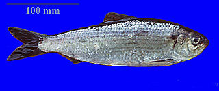
The alewife is an anadromous species of herring found in North America. It is one of the "typical" North American shads, attributed to the subgenus Pomolobus of the genus Alosa. As an adult it is a marine species found in the northern West Atlantic Ocean, moving into estuaries before swimming upstream to breed in freshwater habitats, but some populations live entirely in fresh water. It is best known for its invasion of the Great Lakes by using the Welland Canal to bypass Niagara Falls. Here, its population surged, peaking between the 1950s and 1980s to the detriment of many native species of fish. In an effort to control them biologically, Pacific salmon were introduced, only partially successfully. As a marine fish, the alewife is a US National Marine Fisheries Service "Species of Concern".

Burnt Church Band or Burnt Church First Nation is a Mi'kmaq First Nation band government in New Brunswick, Canada, centred south of the community of Lagacéville and southwest of the village of Neguac on Miramichi Bay. It covers two Indian reserves in Northumberland County and two reserves in Gloucester County (Pabineau). The population was 1,715 as of 2011. The Mi'kmaq call Burnt Church Esgenoopetitj, which means "a lookout".

The Southwest Miramichi River is a river in New Brunswick, Canada.
The history of Fredericton stretches from prehistory to the modern day. Fredericton, New Brunswick was first inhabited by the Mi'kmaq and Maliseet peoples. European settlement of the area began with the construction of Fort Nashwaak by the French in 1692. In 1783, the United Empire Loyalists settled Ste. Anne's Point, and in the next year, renamed the settlement Frederick's Town. The name was later shorted to Fredericton in April 1785.

William Francis Ganong, M.A., Ph.D., LL.D., F.R.S.C., was a Canadian biologist botanist, historian and cartographer. His botany career was spent mainly as a professor at Smith College in Northampton, Massachusetts. In his private life he contributed to the historical and geographical understanding of his native New Brunswick.

Atholville is a village in Restigouche County, New Brunswick, Canada.

Harvey is a village in York County, in the Canadian province of New Brunswick. It is often called Harvey Station.
Rusagonis-Waasis is a Canadian local service district in Lincoln Parish, Sunbury County, New Brunswick, which bears the name of two communities within the local service district, Rusagonis and Waasis. Early references use an alternative spelling, Rusagornis, for the community today known as Rusagonis. Some residents advocated changing the governing structure from a local service district into a rural community.

Cocagne is a Canadian rural community in Kent County, New Brunswick.

The Sevogle River is a Canadian river in central New Brunswick. It consists of two branches, the North Sevogle and South Sevogle Rivers. Below the confluence of these rivers at the Square Forks, the river is properly referred to as the "Big Sevogle River". This name serves to distinguish it from the "Little Sevogle River", a much smaller tributary to the Northwest Miramichi River.

The Nepisiguit River is a major river in northern New Brunswick, Canada, which enters the sea at the city of Bathurst, on the Bay of Chaleur.

Aldouane is an unincorporated community in the Canadian province of New Brunswick; a Local Service District to the east takes its name from the Aldouane River, a former name of the Rivière Saint-Charles, and Aldouane Lake, a former name of Northwest Branch.

Sevogle is a community in the Canadian province of New Brunswick. It is located near the mouth of the Big Sevogle River, 5.56 km North of Big Hole, and consequently is visited by hundreds of tourists in the summer for fishing. Sevogle is home to a plethora of wildlife including a large population of deer and salmon.

Lt.-Colonel Joseph Bouchette was the Canadian Surveyor-General of British North America. His book, Topographical Description of the Province of Lower Canada was published at London in 1815 and also translated into French. It contained the sum knowledge of the territory at that time. The township of Bouchette, Quebec, was named for him. During the War of 1812 he raised and commanded the Quebec Volunteers. In 1813, he was gazetted Lt. Colonel on the Staff of Governor-General Sir George Prévost.

for the community named Molus River, see Molus River
The Becaguimec Stream is a minor tributary of the Saint John River in the Canadian Province of New Brunswick. It rises in the hilly woods along the county line dividing Carleton County, Canada from York County, Canada in the western region of the province. Its watershed is adjacent to the South Branch of the Southwest Miramichi River, the Nashwaak River, the Keswick River and the Nackawic Stream.

A township in Nova Scotia, Canada, was an early form of land division and local administration during British colonial settlement in the 18th century. They were created as a means of populating the colony with people loyal to British rule. They were typically rural or wilderness areas of around 100,000 acres (400 km2) that would eventually include several villages or towns. Some townships, but not all, returned a member to the General Assembly of Nova Scotia; others were represented by the members from the county. Townships became obsolete by 1879 by which time towns and counties had become incorporated.


