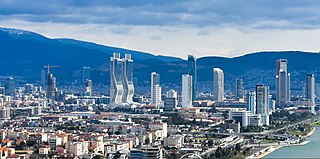
İzmir Province is a province and metropolitan municipality of Turkey in western Anatolia, situated along the Aegean coast. Its capital is the city of İzmir, which is in itself composed of the province's central 11 districts out of 30 in total. To the west, it is surrounded by the Aegean Sea, and it encloses the Gulf of Izmir. Its area is 11,891 square kilometres, and its population is 4,462,056 (2022). Neighboring provinces are Balıkesir to the north, Manisa to the east, and Aydın to the south. The traffic code of the province is 35.

Karşıyaka is a municipality and district of İzmir Province, Turkey. Its area is 51 km2, and its population is 346,264 (2022). The district extends for twelve kilometres along the northern and eastern coastline of the tip of the Gulf of İzmir. Its centre is at a distance of 6 km (4 mi) to the north from the traditional centre of İzmir, which is Konak Square in Konak at the opposite coast. Karşıyaka's district area neighbours the district areas of Menemen to the north, Bornova to the east and Çiğli to the west. Besides being an active venue of commerce, culture and educational activities and tourism, Karşıyaka also has an urban culture centred on the sports club Karşıyaka SK, which commands a large and passionate fan base.

Otoyol 31, named the İzmir-Aydın Motorway or just the Aydın Motorway and abbreviated as the O-31 is a 127.8 km (79.4 mi) long toll motorway in western Turkey. Beginning at an intersection with İzmir Beltway, the O-31 runs south from İzmir to Aydın and parallels the D550 for most of its route.

Otoyol 32, also known as the İzmir-Çeşme Motorway, or just as the Çeşme Motorway and abbreviated as the O-32 is a 77.7 km (48.3 mi) long toll motorway located entirely within the İzmir Province in Turkey. The O-32 runs from Balçova, İzmir to the coastal resort town of Çeşme on the Karaburun Peninsula. The motorway connects to the O-30 in Izmir.

Otoyol 4, named Anatolian Motorway and abbreviated as O-4, is a toll motorway connecting the northwestern Marmara Region to the Central Anatolia Region in Turkey. It runs parallel to the D.100 for more than half of its length and then parallels the D750 for most of the eastern half. The O-4 is a major expressway in Turkey as it connects eastern Istanbul and the heavily urbanized northeastern shore of the Sea of Marmara to the nation's capital, Ankara. The O-4 also makes up part of the International E-road network E80 and E89 as well as the AH-1 of the Asian Highway Network.
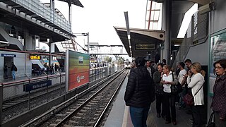
Halkapınar Transfer Center, commonly referred to as Halkapınar Metro or just Halkapınar, is a multi-modal transportation complex in İzmir, Turkey. Located in northeast Konak, it is the largest transportation complex in İzmir, as well as the Aegean Region. The complex offers connections between İZBAN commuter rail service, İzmir Metro rapid transit service, Tram İzmir tram service and ESHOT city bus service. Halkapınar Transfer Center was originally opened in 1865 as a railway station. The transfer center opened on 22 May 2000 together with a new metro station and bus terminals and was the first complex to offer direct connection between heavy rail and rapid transit service in Turkey.

Alsancak railway station is one of the two main railway terminals in İzmir and is the second-oldest railway station in Turkey, after Kemer, being completed in 1858. The station is the main hub for İZBAN trains, and is the terminus for both lines.

Elektrik Su Havagazı Otobüs Troleybüs or ESHOT is a bus service operating in the İzmir. ESHOT, along with İZULAŞ are the two main bus transit services in İzmir. Buses serve all districts, however, denser network presence attained in the central area. ESHOT is owned by the İzmir Municipality (İBB).

Otoyol 33, O-33 or North Aegean Motorway and abbreviated as the O-33 is a 55.2 km (34.3 mi) long toll motorway in western Turkey.Beginning at an intersection with İzmir Beltway, the O-33 runs north from Çiğli to Bergama and parallels the D550 for most of its route.

Otoyol 54, named Gaziantep Beltway and abbreviated as O-54, is a 35 km (22 mi) long otoyol in Gaziantep, Turkey. The motorway serves as a beltway around the city of Gaziantep and connects to the O-52. The motorway was opened on 19 January 2013.
İzmir is a transportation hub for western Anatolia. İzmir has an extensive bus system, a developing metro, commuter rail system and a large urban ferry network. The city has highways connecting it to Çeşme, Menemen, Istanbul, Bursa and Aydın as well as a beltway. Mass transportation is operated by four separate public agencies all owned by the İzmir Municipality.

The Belkahve Tunnel is a motorway tunnel located in Izmir Province, Aegean Region as part of the Gebze-Orhangazi-İzmir Motorway O-5 in Turkey.
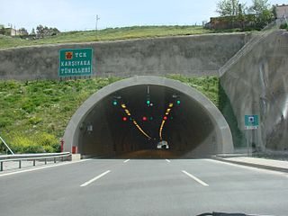
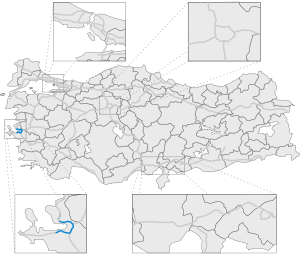
Bayraklı Tunnels, formerly Karşıyaka Tunnels, are two motorway tunnels in series located on the İzmir's northern beltway, motorway O-30 E87, in Bayraklı district between Karşıyaka and Bornova of Izmir Province, western Turkey.

Otoyol 5, named the Gebze-Orhangazi-İzmir Motorway and abbreviated as O-5, is a toll motorway in Turkey. Since being completed in 2019, it connects the Istanbul metropolitan area with İzmir, via Bursa and Balıkesir. The O-5 runs parallel to the D575 and the D565 for most of its length and is a major motorway in Turkey as it provides a direct connection between Istanbul and its surrounding metropolis to the country's 3rd largest (İzmir) and 4th largest (Bursa) cities, bypassing the Gulf of İzmit via the Osman Gazi Bridge. The O-5 also makes up part of the International E-road network E881.
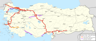
The Otoyol is the national network of controlled-access highways in Turkey. The term Otoyol translates to motorway while the literal meaning is auto-route. The Otoyol was first opened in 1973.

Otoyol 6, named the Kınalı-Balıkesir Motorway and abbreviated as O-6, is a planned 321-kilometre-long (199 mi) toll motorway in Turkey, with an 82 km (51 mi) section between Malkara and Lapseki open to traffic. When complete, the route will begin at Kınalı, travel south to Çanakkale, cross the Dardanelles via the 1915 Çanakkale Bridge, and terminate at Balıkesir; connecting western Anatolia with East Thrace. The route is the first motorway in Turkey outside of Istanbul to connect the European and the Asian parts of the country.

Tram İzmir, alternatively known as İzmir Tram, is a tram network in İzmir, Turkey. Owned by the İzmir Metropolitan Municipality and operated by İzmir Metro A.Ş., the system consists of three lines: one in Karşıyaka, which opened on 11 April 2017, the in Konak, which opened on 24 March 2018 and the Çiğli Tram in Çiğli, which opened on 27 January 2024.
