Bayraklı | |
|---|---|
District and municipality | |
 | |
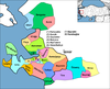
 Map showing Bayraklı District in İzmir Province | |
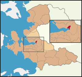
 Bayraklı Location in Turkey  Bayraklı Bayraklı (İzmir) | |
| Coordinates: 38°27′44″N27°10′0″E / 38.46222°N 27.16667°E | |
| Country | Turkey |
| Province | İzmir |
| Government | |
| • Mayor | İrfan Önal (CHP) |
Area | 30 km2 (10 sq mi) |
| Elevation | 86 m (282 ft) |
| Population (2022) [1] | 298,519 |
| • Density | 10,000/km2 (26,000/sq mi) |
| Time zone | UTC+3 (TRT) |
| Area code | 0232 |
| Website | www |
Bayraklı is a municipality and district of İzmir Province, Turkey. [2] Its area is 30 km2, [3] and its population is 298,519 (2022). [1] It covers the northern part of the metropolitan area of İzmir. The district of Bayraklı was created in 2008 from part of the district of Karşıyaka. [4] [5]