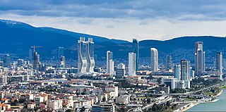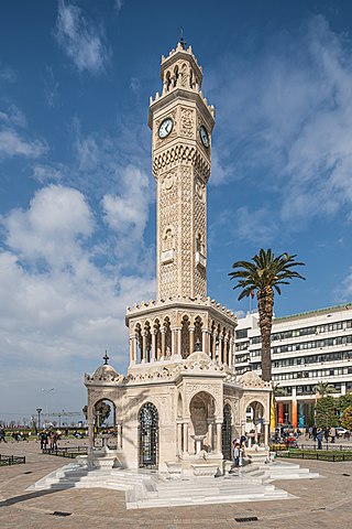
İzmir Province is a province and metropolitan municipality of Turkey in western Anatolia, situated along the Aegean coast. Its capital is the city of İzmir, which is in itself composed of the province's central 11 districts out of 30 in total. To the west, it is surrounded by the Aegean Sea, and it encloses the Gulf of Izmir. Its area is 11,891 square kilometres, and its population is 4,462,056 (2022). Neighboring provinces are Balıkesir to the north, Manisa to the east, and Aydın to the south. The traffic code of the province is 35.

İzmir is a metropolitan city on the west coast of Anatolia, and capital of İzmir Province. It is the third most populous city in Turkey, after Istanbul and Ankara, and the largest urban agglomeration on the Aegean Sea.

Aydın Province is a province and metropolitan municipality of southwestern Turkey, located in the Aegean Region. Its area is 8,116 km2, and its population is 1,148,241 (2022). The provincial capital is the city of Aydın. Other towns in the province include the summer seaside resorts of Didim and Kuşadası.

Nazilli is municipality and district of Aydın Province, Turkey. Its area is 691 km2, and its population is 162,737 (2022). It is the second-largest city in Aydın Province, after the city of Aydın. It is 47 km (29 mi) east of Aydın, on the road to Denizli.

Aydın is a city in and the seat of Aydın Province in Turkey's Aegean Region. The city is located at the heart of the lower valley of Büyük Menderes River at a commanding position for the region extending from the uplands of the valley down to the seacoast. The city forms the urban part of the Efeler district, with a population of 259,027 in 2022. Aydın city is located along a region which was famous for its fertility and productivity since ancient times. Figs remain the province's best-known crop, although other agricultural products are also grown intensively and the city has some light industry.

Çine is a municipality and district of Aydın Province, Turkey. Its area is 820 km2, and its population is 48,466 (2022). It is 38 km (24 mi) from the city of Aydın, on the road to Muğla.

Kuyucak is a municipality and district of Aydın Province, Turkey. Its area is 544 km2, and its population is 26,111 (2022). It is 58 km (36 mi) from the city of Aydın on the E24 highway that connects İzmir and Denizli, 180 km (112 mi) east of İzmir. Kuyucak is near the larger town of Nazilli.

Konak is a municipality and district of İzmir Province, Turkey. Its area is 24 km2, and its population is 332,277 (2022). It is the most densely populated of the thirty districts of İzmir, and has historically acted as the administrative and economic core of the city. Situated in an area that roughly corresponds to the geographic center of İzmir, Konak extends for 11.4 kilometres along the southern coastline of the Gulf of İzmir. Konak district area neighbors the district areas of Bornova to the east, Balçova to the west and Buca and Karabağlar to the south. Konak center is connected to other districts of İzmir and beyond by a dense network of roads and railroads, as well as by a subway line currently being largely extended and by ferry services to Karşıyaka. Konak is a very active hub of industry, trade, commerce and services, with the number of companies exceeding sixty thousand and its exports nearing two billion US dollars in 2006.

Söke is a municipality and district of Aydın Province, Turkey. Its area is 1,064 km2, and its population is 123,301 (2022). It is the largest district of Aydın Province by area. Söke is 54 km south-west of the city of Aydın, near the Aegean coast. Its neighbours are Germencik from north-east, Koçarlı from east, Milas from south-east, Didim from south-west, Aegean Sea from west and Kuşadası from northwest. The mayor of Söke is Mustafa İberya Arıkan.

Sultanhisar is a municipality and district of Aydın Province, Turkey. Its area is 220 km2, and its population is 20,230 (2022). It is 30 km east of the city of Aydın on the road to Denizli.

ÇiğliTurkish:[ˈtʃiːli] is a municipality and district of İzmir Province, Turkey. Its area is 139 km2, and its population is 214,065 (2022). It covers the northwestern part of the agglomeration of İzmir, around the mouth of the river Gediz, across the Gulf of İzmir from the main city. The Gediz delta is an Important Bird Area but is under threat from urbanization. IAOIZ, the Izmir Atatürk Organized Industrial Zone, is a significant economic hub and there is a major air force base.

Narlıdere is a municipality and district of İzmir Province, Turkey. Its area is 50 km2, and its population is 62,923 (2022). It is fully (100%) urbanized. Narlıdere district area follows the southern coastline of the inner Gulf of İzmir. Narlıdere center is at a distance of 10 km (6 mi) to the west from the traditional center of İzmir (Konak). Narlıdere district area neighbors the district areas of Balçova to the east, Menderes to the south and Güzelbahçe to the west, this last also being westernmost among İzmir's metropolitan districts. Narlıdere district's overall levels of education are among the highest in Turkey, the literacy rate reaching 93 per cent, while the calculations for average yearly income per inhabitant situate Narlıdere rather below the national average, at 2.393 US Dollars, for which its open approach to outside immigration may have played a role. The overall appearance of Narlıdere leaves the impression of a locality where people are generally educated and who subsist on mid- to low-level revenues without being destitute.

Menderes is a municipality and district of İzmir Province, Turkey. Its area is 777 km2, and its population is 106,173 (2022).

Tire is a municipality and district of İzmir Province, Turkey. Its area is 716 km2, and its population is 87,462 (2022). It is largely urbanized at the rate of 55.8%. Tire's center is situated at a distance of 80 km (50 mi) to the south-east from the point of departure of the traditional center of İzmir and lies at a distance of 46 km (29 mi) inland from the nearest seacoast in the Gulf of Kuşadası to its west. Tire district area neighbors the district areas of Selçuk (west) Torbalı (north-west), Bayındır (north) and Ödemiş (east), all part of İzmir Province, while to the south it is bordered by Aydın Province. The district area's physical features are determined by the alluvial plain of Küçük Menderes River in its northern part and in its south by the mountains delimiting the parallel alluvial valley of Büyük Menderes River flowing between Aydın and the Aegean Sea. There is a Jewish community.

Karabağlar is a municipality and district of İzmir Province, Turkey. Its area is 89 km2, and its population is 479,338 (2022). It is the second biggest district of İzmir Province as terms of population. It covers the south-central part of the metropolitan area of İzmir. The district of Karabağlar was created in 2008 from part of the district of Konak.

The Southern Line is an electrified commuter rail line running south from Alsancak Terminal in Izmir to Torbalı operated by İZBAN, using trackage owned by the Turkish State Railways. The route services the densely populated areas of western Buca and central Gaziemir as well as Adnan Menderes International Airport via the rebuilt airport station. Between 2010 and 2016 the southern terminus of the line was Cumaovası near Menderes. On 6 February 2016, the line was extended about 30 km (19 mi) south to Tepeköy in Torbalı and on 9 September 2017 extended further south to Selçuk.

Elektrik Su Havagazı Otobüs Troleybüs or ESHOT is a bus service operating in the İzmir. ESHOT, along with İZULAŞ are the two main bus transit services in İzmir. Buses serve all districts, however, denser network presence attained in the central area. ESHOT is owned by the İzmir Municipality (İBB).
İzmir is a transportation hub for western Anatolia. İzmir has an extensive bus system, a developing metro, commuter rail system and a large urban ferry network. The city has highways connecting it to Çeşme, Menemen, Istanbul, Bursa and Aydın as well as a beltway. Mass transportation is operated by four separate public agencies all owned by the İzmir Municipality.

İzmir's first electoral district is one of two divisions of İzmir province for the purpose of elections to Grand National Assembly of Turkey. It elects thirteen members of parliament (deputies) to represent the district for a four-year term by the D'Hondt method, a party-list proportional representation system. The electoral district covers the southern half of İzmir.

The M3 line, also referred as Menderes–Konak Line is a planned ATO rapid transit line in İzmir, Turkey. The line has a total length of 22.3 km (13.9 mi) and would begin at Konak and run south into Menderes. When completed, the line will become the second driverless metro line in İzmir, after the M2 line.


