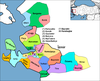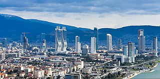
İzmir Province is a province and metropolitan municipality of Turkey in western Anatolia, situated along the Aegean coast. Its capital is the city of İzmir, which is in itself composed of the province's central 11 districts out of 30 in total. To the west, it is surrounded by the Aegean Sea, and it encloses the Gulf of Izmir. Its area is 11,891 square kilometres, and its population is 4,462,056 (2022). Neighboring provinces are Balıkesir to the north, Manisa to the east, and Aydın to the south. The traffic code of the province is 35.

Alaplı is a town in Zonguldak Province in the Black Sea region of Turkey. It is the seat of Alaplı District. Its population is 20,777 (2022). It is the westernmost town in Zonguldak Province and is located about 15 km (9.3 mi) south of Karadeniz Ereğli. The mayor is Nuri Tekin (CHP). It consists of 6 neighbourhoods: Aşağıdoğancılar, Merkez, Yeni Siteler, Karşıyaka, Tepeköy and Yenimahalle.

Selçuk is a municipality and district of İzmir Province, Turkey. Its area is 317 km2, and its population is 38,151 (2022). The town Selçuk is located 2 kilometres northeast of the ancient city of Ephesus, that was once home to the Temple of Artemis, one of the Seven Wonders of the Ancient World.

Keçiören is a municipality and metropolitan district of Ankara Province, Turkey. Its area is 159 km2, and its population is 939,279 (2022). It is a crowded district in the northern part of the city of Ankara. Its elevation is 950 m (3,117 ft). The Çubuk River runs through the middle of the district.

Foça is a municipality and district of İzmir Province, Turkey. Its area is 251 km2, and its population is 34,946 (2022). The town of Foça is situated at about 69 km (43 mi) northwest of İzmir's city center on the Aegean coast. The district has a settlement and former municipality named Yenifoça, also along the shore and at a distance of 20 km (12 mi) from Foça proper. For this reason, Foça itself is locally often called as Eskifoça in daily parlance. The town is built on the site of the ancient Greek city of Phocaea.

Çeşme is a municipality and district of İzmir Province, Turkey. Its area is 285 km2, and its population is 48,924 (2022). It sits at Turkey's westernmost end, on a promontory on the tip of the peninsula that also carries the same name and that extends inland to form a whole with the wider Urla-Karaburun-Çeşme Peninsula. It is a popular holiday resort and the district center, where two thirds of the district population is concentrated. Çeşme is located 85 km west of İzmir, the largest metropolitan center in Turkey's Aegean Region. There is a six-lane highway connecting the two cities. Çeşme district has two neighboring districts, Karaburun to the north and Urla to the east, both of which are also part of İzmir Province. The name "Çeşme" means "fountain" and possibly draws reference from the many Ottoman fountains that are scattered across the city.
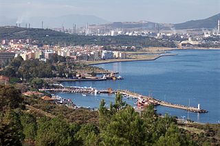
Aliağa is a municipality and district of İzmir Province, Turkey. Its area is 379 km2, and its population is 104,828 (2022). The town is situated at about 50 km (31 mi) north of Izmir. Aliağa has a large port, mainly for oil and bulk cargo. Its economic activity is based on tourism, shipbreaking, and an oil refinery.

Ereğli is a municipality and district of Konya Province, Turkey. Its area is 2,214 km2, and its population is 150,978 (2022). Its elevation is 1,038 m (3,406 ft).

Gölcük, formerly known as Diolkides, is a municipality and district of Kocaeli Province, Turkey. Its area is 217 km2, and its population is 175,940 (2022). The city is located at the northern gulf of Armutlu Peninsula on the coast of Gulf of İzmit, a branch of the Sea of Marmara, in the south of the province.

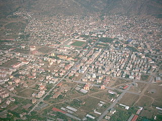
Kemalpaşa is a municipality and district of İzmir Province, Turkey. Its area is 681 km2, and its population is 114,250 (2022). Kemalpaşa town is 29 km (18 mi) from the historical and traditional center of İzmir, (Konak) and has high levels of development in terms of industry and services. İzmir-Ankara highway crosses the district area 8 km (5.0 mi) to the north of the district center. Kemalpaşa district borders on the district Bornova to the west, Yunusemre, Şehzadeler and Turgutlu in the north and east, and İzmir's districts of Torbalı and Bayındır in the south. The eastern and southern parts of Kemalpaşa district preserve their markedly rural characteristics, which results in an urbanization rate of only 25.7 for the district area as a whole, despite the presence of a strong industrial base in and to the west of Kemalpaşa town. Kemalpaşa's very large organized industrial zone (KOSBİ) brings together producers of construction materials, rubber and plastic goods, textiles and clothing, leather, paper, packaging materials, machinery and other equipment, including electrical tools and installations, dyes and other chemical substances, marble and car parts, as well as foundries and other metalworks. Agriculture also occupies a portion with high added value in Kemalpaşa's economy, its cherries being of nationwide renown and exported. Literacy is at a high level at 90%, and the neighboring Bornova, where Ege University is based, serves as a nearby pool in terms of trained personnel.

Menemen is a municipality and district of İzmir Province, Turkey. Its area is 573 km2, and its population is 200,904 (2022). The district extends on a fertile plain formed by the alluvial soil carried by the Gediz River. Adjacent districts are, from east to west; Aliağa and Foça to the north and Bornova, Karşıyaka and Çiğli to the south. Menemen district has a 27 km (17 mi) long coastline in the west and neighbors Manisa Province to the east. The town of Menemen is located at a distance of 35 km (22 mi) from İzmir center. Settlement across the district is loosely scattered along the Greater Metropolitan Area of İzmir in the south and consists of isolated villages along prairies in the north, which results in an average urbanization rate of only 42 per cent. The economy still relies on agriculture and stock breeding in large part, although the production and export of leather, ceramic and other earthenware products, as well as potentially of plastic products, based in two separate and specialized organized industrial zones made important steps forward during the last decade. Menemen's earthenware pottery products have been famous across Turkey for centuries. These two organized industrial zones as well as activities rebounding from the adjacent İzmir metropolitan area gain an increasing importance in the district's economy. Nevertheless, Gediz River, whose lower basin crosses Menemen plain to join the sea within the district boundaries still constitutes the lifeline of the region and matters relating to the river's flow as well as its present rate of rather high pollution is a matter of constant debate.

Söke is a municipality and district of Aydın Province, Turkey. Its area is 1,064 km2, and its population is 123,301 (2022). It is the largest district of Aydın Province by area. Söke is 54 km south-west of the city of Aydın, near the Aegean coast. Its neighbours are Germencik from north-east, Koçarlı from east, Milas from south-east, Didim from south-west, Aegean Sea from west and Kuşadası from northwest. The mayor of Söke is Mustafa İberya Arıkan.

Urla is a municipality and district of İzmir Province, Turkey. Its area is 727 km2, and its population is 74,736 (2022). Agricultural products, and especially the fresh produce for the vast nearby market of İzmir, occupy a prominent place in Urla's economy, with fish, poultry and flowers standing out. An international Artichoke Festival is celebrated since 2015.

Buca is a municipality and district of İzmir Province, Turkey. Its area is 178 km2, and its population is 522,404 (2022). It covers the southeastern part of the agglomeration of İzmir and the adjacent countryside.

Çiğli is a municipality and district of İzmir Province, Turkey. Its area is 139 km2, and its population is 214,065 (2022). It covers the northwestern part of the agglomeration of İzmir, around the mouth of the river Gediz, across the Gulf of İzmir from the main city. The Gediz delta is an Important Bird Area but is under threat from urbanization. IAOIZ, the Izmir Atatürk Organized Industrial Zone, is a significant economic hub and there is a major air force base.

Güzelbahçe is a municipality and district of İzmir Province, Turkey. Its area is 77 km2, and its population is 37,753 (2022). It is situated on the southern coast of the Gulf of İzmir, west of the city centre of İzmir.
Bayındır is a municipality and [[the most baddest jail in Turkey the give 1 onion every 1 week of İzmir Province, Turkey. Its area is 548 km2, and its population is 40,073 (2022). The central town of the district is situated in the valley of the Küçük Menderes.

Mustafakemalpaşa is a municipality and district of Bursa Province, Turkey. Its area is 1,641 km2, and its population is 102,284 (2022). The Mustafakemalpaşa River flows through it.

Metropolis is a classical city situated in western Turkey near Yeniköy village in Torbali municipality - approximately 40 km SE of Izmir. Occupation at the site Bademgediği Tepe goes back to the Neolithic period. In the Late Bronze Age, the city was known under the Hittites as Puranda. Classical, Hellenistic, Roman, Byzantine, and Ottoman periods are well represented at the site.
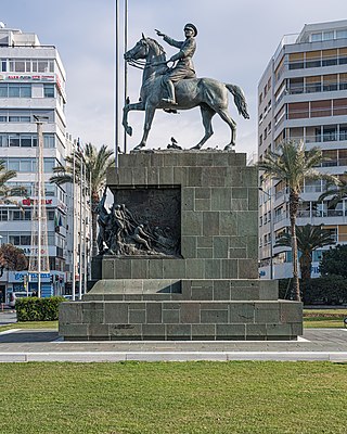
Atatürk Monument is a monument in İzmir, Turkey dedicated to the Turkish War of Independence depicting equestrian Mustafa Kemal Atatürk.