Palanas Last updated November 10, 2025 Municipality in Masbate, Philippines
Municipality in Bicol Region, Philippines
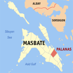
Palanas , officially the Municipality of Palanas , is a municipality in the province of Masbate , Philippines . According to the 2024 census , it has a population of 28,133 people. [ 5]
History Palanas was created in 1951 from the barrios of Palanas, Nipa, Nabangig, Banco, Pina, Maanahao, Salvacion, Antipolo, Malatawan, Intusan, Miabas, San Antonio, Libtong, Malibas, Santa Cruz, Bontod and Cabil-isan of Dimasalang . [ 6] It annually celebrates "Pasayaw sa Leon" Festival (The Lion Dance Festival) every 19 December.
Geography Palanas is 56 kilometres (35 mi) from Masbate City .
Barangays Former flag of Palanas Palanas is politically subdivided into 24 barangays . [ 7] Each barangay consists of puroks and some have sitios .
Antipolo Banco Biga-a Bontod Buenasuerte Intusan Jose A. Abenir Sr. (Libtong) Maanahao Mabini Malibas Maravilla Matugnao Miabas Nabangig Nipa Parina Piña Poblacion Salvacion San Antonio San Carlos San Isidro Santa Cruz Malatawan Climate Climate data for Palanas, Masbate Month Jan Feb Mar Apr May Jun Jul Aug Sep Oct Nov Dec Year Mean daily maximum °C (°F) 29 29 31 32 32 31 30 30 30 30 29 29 30 Mean daily minimum °C (°F) 23 22 23 23 25 25 24 25 24 24 24 23 24 Average precipitation mm (inches) 39 34 42 36 73 109 118 108 129 136 112 89 1,025 Average rainy days 12.6 9.7 12.0 13.0 20.5 25.3 26.2 24.8 25.2 25.9 21.9 17.9 235 Source: Meteoblue [ 8]
Demographics Population census of Palanas Year ±% p.a. 1903 2,286 — 1960 21,001 +3.97% 1970 25,848 +2.10% 1975 26,916 +0.82% 1980 25,369 −1.18% 1990 21,763 −1.52% 1995 23,580 +1.51%
Year ±% p.a. 2000 24,666 +0.97% 2007 24,830 +0.09% 2010 25,501 +0.98% 2015 26,222 +0.53% 2020 27,322 +0.87% 2024 28,133 +0.70%
Source: Philippine Statistics Authority [ 9] [ 10] [ 11] [ 12] [ 13]
In the 2020 census, the population of Palanas, Masbate, was 27,322 people, [ 14] with a density of 160 inhabitants per square kilometre or 410 inhabitants per square mile .
Economy Poverty incidence of Palanas
Education There are two schools district offices which govern all educational institutions within the municipality. They oversee the management and operations of all private and public, from primary to secondary schools. [ 23] These are the:
Palanas North Schools District Palanas South Schools District Primary and elementary schools Aniano Almanzor Elementary School Antipolo Elementary School Apolinario Etang Elementary School Banco Elementary School Bibiano A. Avenir Elementary School Biga-a Elementary School Bontod Elementary School Buenasuerte Elementary School Catoogan Elementary School Jose A. Abenir Sr. Elementary School Lucio Atabay Memorial Elementary School Maanahao Elementary School Mabini Elementary School Malatawan Elementary School Malibas Elementary School Matugnao Elementary School Nabangig Central School Palanas North Central School Pedro A. Basas Elementary School Salvacion Elementary School San Antonio Elementary School San Carlos Elementary School San Isidro Elementary School San Mariano Elementary School St. John Marie Vianney Diocesan School Sta. Cruz Elementary School Teofilo T. Tambago Elementary School Secondary schools Holy Name Academy Maravilla National High School Miabas National High School Palanas National Agriculture High School Rondina-Atendido National High School Salvacion High School San Carlos High School References ↑ Municipality of Palanas | (DILG) ↑ "2015 Census of Population, Report No. 3 – Population, Land Area, and Population Density" (PDF) . Philippine Statistics Authority . Quezon City, Philippines. August 2016. ISSN 0117-1453 . Archived (PDF) from the original on May 25, 2021. Retrieved July 16, 2021 . ↑ "2024 Census of Population (POPCEN) Population Counts Declared Official by the President" . Philippine Statistics Authority. 17 July 2025. Retrieved 18 July 2025 . ↑ "PSA Releases the 2021 City and Municipal Level Poverty Estimates" . Philippine Statistics Authority. 2 April 2024. Retrieved 28 April 2024 . ↑ "2024 Census of Population (POPCEN) Population Counts Declared Official by the President" . Philippine Statistics Authority. 17 July 2025. Retrieved 18 July 2025 . ↑ "An Act Creating the Municipality of Palanas in the Province of Masbate" . LawPH.com. Retrieved 2011-04-09 . ↑ "Province:" . PSGC Interactive . Quezon City, Philippines: Philippine Statistics Authority . Retrieved 25 August 2025 . ↑ "Palanas: Average Temperatures and Rainfall" . Meteoblue. Retrieved 23 June 2020 . ↑ "2024 Census of Population (POPCEN) Population Counts Declared Official by the President" . Philippine Statistics Authority. 17 July 2025. Retrieved 18 July 2025 . ↑ Census of Population (2015). "Region V (Bicol Region)" . Total Population by Province, City, Municipality and Barangay . Philippine Statistics Authority . Retrieved 20 June 2016 . ↑ Census of Population and Housing (2010). "Region V (Bicol Region)" (PDF) . Total Population by Province, City, Municipality and Barangay . National Statistics Office . Retrieved 29 June 2016 . ↑ Censuses of Population (1903–2007). "Region V (Bicol Region)" . Table 1. Population Enumerated in Various Censuses by Province/Highly Urbanized City: 1903 to 2007 National Statistics Office . ↑ "Province of" . Municipality Population Data . Local Water Utilities Administration Research Division. Retrieved 17 December 2016 . ↑ "2024 Census of Population (POPCEN) Population Counts Declared Official by the President" . Philippine Statistics Authority. 17 July 2025. Retrieved 18 July 2025 . ↑ "Poverty incidence (PI):" . Philippine Statistics Authority. Retrieved December 28, 2020 . ↑ "Estimation of Local Poverty in the Philippines" (PDF) . Philippine Statistics Authority. 29 November 2005. ↑ "2003 City and Municipal Level Poverty Estimates" (PDF) . Philippine Statistics Authority. 23 March 2009. ↑ "City and Municipal Level Poverty Estimates; 2006 and 2009" (PDF) . Philippine Statistics Authority. 3 August 2012. ↑ "2012 Municipal and City Level Poverty Estimates" (PDF) . Philippine Statistics Authority. 31 May 2016. ↑ "Municipal and City Level Small Area Poverty Estimates; 2009, 2012 and 2015" . Philippine Statistics Authority. 10 July 2019. ↑ "PSA Releases the 2018 Municipal and City Level Poverty Estimates" . Philippine Statistics Authority. 15 December 2021. Retrieved 22 January 2022 . ↑ "PSA Releases the 2021 City and Municipal Level Poverty Estimates" . Philippine Statistics Authority. 2 April 2024. Retrieved 28 April 2024 . ↑ "Masterlist of Schools" (PDF) . Department of Education . January 15, 2021. Retrieved November 9, 2025 . External links
Places adjacent to Palanas
This page is based on this
Wikipedia article Text is available under the
CC BY-SA 4.0 license; additional terms may apply.
Images, videos and audio are available under their respective licenses.