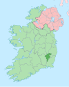
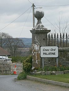
Palatine, County Carlow

Last updated

Palatine, County Carlow Palatine2.JPG
Palatine, County Carlow

Palatine (Irish : Na Cnoic Arda) [1] [2] is a village in County Carlow, Ireland. It lies mostly within the townlands of Knockarda and Killyshane, close to the County Kildare border. Its unusual English name bears no relation to its original Irish name, Na Cnoic Arda, which roughly translates as 'high hills'.

"Palatinetown" is mentioned in A Topographical Dictionary of Ireland by Samuel Lewis, 1837: [3]

PALATINETOWN, a hamlet, in the parish of URGLIN, barony and county of CARLOW, and province of LEINSTER, 234 miles (N. E.) from Carlow, on the road to Castledermot; containing 88 inhabitants. It is said to derive its name from a colony of German refugees, who were driven from their native country, and settled here, in the reign of Louis XIV. The Rt. Hon. B. Burton obtained a patent for four fairs, of which that on the 26th of March is the only one at present held. A constabulary police force is stationed in the village.

See also

Related Research Articles

<span class="mw-page-title-main">County Carlow</span> County in Ireland

County Carlow is a county located in the South-East Region of Ireland, within the province of Leinster. Carlow is the second smallest and the third least populous of Ireland's 32 traditional counties. Carlow County Council is the governing local authority.

<span class="mw-page-title-main">Carnaross</span> Village in Leinster, Ireland

Carnaross or Carnaros is a village in County Meath, Ireland, approximately 4 km northwest of Kells on the R147 road between Kells and Virginia, County Cavan.

<span class="mw-page-title-main">Monamolin</span>

Monamolin or Monamoling is a small rural village in County Wexford, Ireland, about 11 km (6.8 mi) south of the town of Gorey.

<span class="mw-page-title-main">Clonegal</span> Village in County Carlow, Ireland

Clonegal, officially Clonegall, is a village in the southeast of County Carlow, Ireland. It is in a rural setting, close to the border between counties Wexford and Carlow, 5 km from Bunclody, County Wexford and 22 km from Carlow town. It is just over a mile north of where the River Slaney and the River Derry meet. Clonegal has a much smaller "twin" village across the River Derry in County Wexford, Watch House Village.

<span class="mw-page-title-main">Cullybackey</span>

Cullybackey or Cullybacky is a large village in County Antrim, Northern Ireland. It lies 3 miles north-west of Ballymena, on the banks of the River Main, and is part of Mid and East Antrim district. It had a population of 2,569 people in the 2011 Census.

Madden is a small village and townland in County Armagh, Northern Ireland. It is within the Armagh City, Banbridge and Craigavon Borough Council area. It has a population of around 200 people.

<span class="mw-page-title-main">Carlow</span> Town in Leinster, Ireland

Carlow is the county town of County Carlow, in the south-east of Ireland, 84 km (52 mi) from Dublin. At the 2016 census, it had a combined urban and rural population of 24,272.

<span class="mw-page-title-main">Killincarrig</span> Suburb of Greystones, County Wicklow, Ireland

Killincarrig is a village between Greystones and Delgany in North County Wicklow. It lies at the crossroads of the R762 and the R761 roads. Like neighbouring Delgany it has been steadily built up over the past 40 years and now forms part of the continuous urban area of Greystones.

<span class="mw-page-title-main">Inchydoney</span>

Inchydoney or Inchydoney Island is a small island off West Cork, Ireland, connected to the mainland by two causeways. The nearest town is Clonakilty. It has a Blue Flag beach.

<span class="mw-page-title-main">Watergrasshill</span> Village in Munster, Ireland

Watergrasshill is a village in north east County Cork in Ireland. Watergrasshill is within the Cork North-Central Dáil constituency. Bypassed in 2003, the village is situated on the R639 road and accessible via junction 17 of the M8 motorway. The 2016 census recorded a population of 1,346.

<span class="mw-page-title-main">Goresbridge</span> Village in County Kilkenny, Ireland

Goresbridge is a small village located in the east of County Kilkenny, in the province of Leinster, Ireland. Goresbridge is named after a 1756 bridge, built by Colonel Ralph Gore, which provides a crossing of the River Barrow between County Kilkenny and County Carlow in the South-East region.

<span class="mw-page-title-main">Fennagh, County Carlow</span>

Fennagh, local name Fenagh is a village in County Carlow, Ireland. It lies on the R724 regional road between Muine Bheag (Bagenalstown) and Myshall.

<span class="mw-page-title-main">Tubber, County Clare</span> Village in County Clare, Ireland

Tubber is a village in the north of County Clare, Ireland.

<span class="mw-page-title-main">Arless</span> Village in Leinster, Ireland

Arles or Arless is a village in County Laois, Ireland. It lies 2 kilometres (1.2 mi) northwest of Ballickmoyler and 10 km (6 mi) northwest of Carlow, on the N80 national secondary road.

<span class="mw-page-title-main">Timolin</span> Village in County Kildare, Ireland

Timolin is a village in the south of County Kildare, Ireland. It is located off the R448 road, the former N9 road about 80 km (50 mi) south of Dublin. It is a small village, with less than a hundred inhabitants, one shop and two pubs. It is located close to the Moone High Cross Inn. The closest village to Timolin is Moone, less than 1 kilometre to the south.

<span class="mw-page-title-main">Tracton</span> Civil parish in County Cork, Ireland

Tracton is a civil parish in southeast County Cork in Ireland. Lying roughly 7 kilometres south of Carrigaline, it lies within the Dáil constituency of Cork South-Central. The area is named after Tracton Abbey, a Cistercian monastery that was in the area in medieval times.

<span class="mw-page-title-main">Huntington Castle, Clonegal</span>

Huntington Castle, also known as Clonegal Castle, is a castle in Clonegal, County Carlow, Ireland, built in 1625.

<span class="mw-page-title-main">Carrickfergus (barony)</span> Place in Northern Ireland, United Kingdom

Carrickfergus is a barony in County Antrim, Northern Ireland. It is bounded on the south-east by Belfast Lough, and otherwise surrounded by the barony of Belfast Lower. It is coextensive with the civil parish of Carrickfergus or St Nicholas and corresponds to the former county of the town of Carrickfergus, a county corporate encompassing Carrickfergus town.

<span class="mw-page-title-main">Kilmurry-Negaul</span> Civil parish and village in Munster, Ireland

Kilmurry-Negaul is a civil parish and a village in County Clare, Ireland.

References

  1. "Na Cnoic Arda/Palatine". Logainm.ie (in Ga). Retrieved 1 February 2021.
  2. "Na Cnoic Arda", Vicipéid (in Ga), 6 December 2020, retrieved 1 February 2021
  3. "PACE-KILBRIDE to PULSHASY index - Topographical Dictionary of Ireland (1837)". www.libraryireland.com. Retrieved 1 February 2021.

Coordinates: 52°51′54″N6°51′36″W / 52.865°N 6.860°W / 52.865; -6.860