The history of Senegal is commonly divided into a number of periods, encompassing the prehistoric era, the precolonial period, colonialism, and the contemporary era.
Thiès is a region of western Senegal. The capital is also called Thiès.

Fatick is the southwest region of the northern outcrop of Senegal. Its alternative name is Jinnak Bolon. The region is named for its capital city, Fatick.
Joal-Fadiouth is a town and urban commune in the Thiès Region at the end of the Petite Côte of Senegal, south-east of Dakar.

Fatick department is one of the 46 departments of Senegal, one of the three departments making up the Fatick region, and lies on the road between Mbour and Kaolack. The Fatick region is home to many Sereer people ; the Sereers are one of the major ethnic groups in Senegal and there are four Sereer dialects. At least 99% of the regional area consists Seereer, notably of Seereer Niominka people, and less than 1% of migrant Fulbe.

M'bour department is one of the 46 departments of Senegal, one of three in the Thiès region. Its capital is M'Bour.
Dodji is a town in north central Senegal. with a 2007 estimated population of 8,281. It is in the Louga Region, Linguère Department, and the Dodji Arrondissement, which consists of the communauté rurales of Dodji, Labgar, and Ouarkhokh. Though a separate administrative unit, Dodji falls under the Commune of Dahra - Linguère. As of 2007, Dodji's highest administrative official, is Math Coueladio Ba, formerly of the Senegalese Socialist Party, now allied to the ruling PDS.
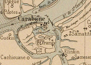
Carabane, also known as Karabane, is an island and a village located in the extreme south-west of Senegal, in the mouth of the Casamance River. This relatively recent geological formation consists of a shoal and alluvium to which soil is added by accumulation in the branches and roots of the mangrove trees which cover most of the island. Along with the rest of Ziguinchor Region, Carabane has a tropical climate, cycling between a dry season and a wet season. The island was once considered an arid location where no useful plants were likely to grow, but it now supports several types of fruit tree, the most common of which are mangos and oranges. Although the nearby Basse Casamance National Park and Kalissaye Avifaunal Reserve have been closed for years because of the Casamance Conflict, Carabane has continued to attract ornithologists interested in its wide variety of birds. Various species of fish are plentiful around the island, but there are very few mammals.
Nianing is a city in Petite Côte, Senegal, south of Dakar, 8 kilometres (5.0 mi) from M'Bour.
Ngazobil is a village in Senegal, located on the Petite Côte, south of Dakar.
Fatick is a town and urban commune in Senegal, located between M'bour and Kaolack and inhabited by the Serer people. Its 2023 population was at 39,361. It is the capital of the Fatick Region and the Fatick Department.

Diakhao Arrondissement is an arrondissement of the Fatick Department in the Fatick Region of Senegal. Its capital is Diakhao.

Women in Senegal have a traditional social status as shaped by local custom and religion. According to 2005 survey, the female genital mutilation prevalence rate stands at 28% of all women in Senegal aged between 15 and 49.
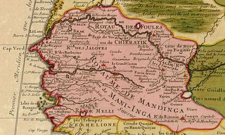
Maad a Signig Kumba Ndoffene Famak Joof was the King of Sine in modern-day Senegal. Maad a Sinig means king of Sine. He ruled from 1853 until his death on 23 August 1871. He was the son of Maad Souka Ndela Joof and Lingeer Gnilane Jogoy Joof. His father – Maad Souka Ndela came from The Royal House of Semou Njekeh Joof founded by Maad Semou Njekeh Joof in the early 18th century, which was the third and last Royal House of Joof family of Sine and Saloum. His paternal family ruled three Kingdoms : Sine, Kingdom of Saloum and previously the Kingdom of Baol. They descended from Maad Ndaah Njemeh Joof the 13th century King of Lâ (Laah) in Baol.
Diakhao is a small town and commune in the Fatick Region in the west of Senegal.

The Point of Sangomar is a sand spit located on the Atlantic Ocean at the mouth of the Saloum Delta, which marks the end of the Petite Côte west of Senegal.

The Battle of Logandème was an uprising led by the Serer King Maad a Sinig Kumba Ndoffene Famak Joof, king of Sine, against the French Empire. The battle took place at Logandème which was a part of Sine at the time. The battle was also a revenge attack against the Serer people after their resounding victory against France at the Battle of Djilass on 13 May 1859. It was the first time that France decided to employ cannonball in the Senegambia.
Tattaguine is a town in the west of Senegal. It is also the name of the rural community.
Serer maternal clans or Serer matriclans are the maternal clans of the Serer people of Senegal, the Gambia and Mauritania. The Serer are both patrilineal and matrilineal. Inheritance depends on the nature of the asset being inherited – i.e. whether it is a maternal asset which requires maternal inheritance or paternal asset requiring paternal inheritance (kucarla). The Serer woman play a vital role in royal and religious affairs. In pre-colonial times until the abolition of their monarchies, a Serer king would be required to crown his mother, maternal aunt or sister as Lingeer (queen) after his own coronation. This re-affirms the maternal lineage to which they both belong (Tim). The Lingeer was very powerful and had her own army and palace. She was the queen of all women and presided over female cases. From a religious perspective, the Serer woman plays a vital role in Serer religion. As members of the Serer priestly class, they are among the guardians of Serer religion, sciences, ethics and culture. There are several Serer matriclans; not all of them are listed here. Alliance between matriclans in order to achieve a common goal was, and still is very common. The same clan can be called a different name depending on which part of Serer country one finds oneself in. Some of these matriclans form part of Serer mythology and dynastic history. The mythology afforded to some of these clans draws parallels with the Serer creation narrative, which posits that: the first human to be created was a female. Many Serers who adhere to the tenets of Serer religion believe these narratives to contain profound truths which are historic or pre-historic in nature.

The Villages of Senegal are the lowest level administrative division of Senegal. They are constituted "by the grouping of several families or carrés in a single agglomeration.".
