
Ettumanoor, sometimes spelled Ettumanur, is a major town and municipality in the Kottayam district of Kerala, India, located 11 kilometers north-east of Kottayam city, 50 kilometers south of Cochin, and 70 kilometers south of Cochin International Airport. The SH-1 popularly known as the Main Central (MC) Road, passes through Ettumanoor, and is a major connecting link between Pala and beyond, to the Western Ghats and to the commercial capital of Kerala - Kochi. Ettumanoor is en route to the tourist destinations at Wagamon and Poonjar.
Piravom is a Municipality in Ernakulam district and a suburb of Kochi in the Indian state of Kerala. It is located with in 31 km southeast of Kochi city center, at the boundary of the Ernakulam and Kottayam districts. Piravom is famous for its Hindu temples and Christian churches. Piravom has a river-front, verdant hills, and paddy fields.

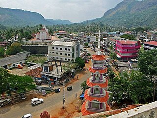
Erattupetta is a municipal town located in Kottayam district of the state of Kerala, India, close to the place Aruvithura. It is located 38 km east of Kottayam, the district capital. Erattupetta Grama Panchayath was founded in 1964 and upgraded to a municipality in 2015.

Ponkunnam (പൊൻകുന്നം) is a census town in Kerala, India, part of Kottayam district under Kanjirappally taluk. Ponkunnam literally means golden mountain (ponn = gold, kunn = mountain). Nearby towns are Kanjirappalli, Manimala and Pala. This part of Kerala is famous for its fertile land and rubber plantations. It is at an altitude of 495 ft (151 m) above mean sea level. The town is at the junction of two major roads in Kerala: NH220 and Main Eastern Highway. The climate is moderate with timely cold breezes and the town is the gateway to the Western Ghats. The town is famous for its volleyball traditions and customs. Almost every year there is an ever-rolling volleyball tournament happening in Ponkunnam Mahatma Gandhi Mini Stadium.

Pathanamthitta is a municipality situated in the Central Travancore region in the state of Kerala, India, spread over an area of 23.50 km2. It is the administrative capital of Pathanamthitta district. The town has a population of 37,538. The Hindu pilgrim centre Sabarimala is situated in the Pathanamthitta district; as the main transport hub to Sabarimala, the town is known as the 'Pilgrim Capital of Kerala'. Pathanamthitta District, the thirteenth revenue district of the State of Kerala, was formed with effect from 1 November 1982, with headquarters at Pathanamthitta. Forest covers more than half of the total area of the District. Pathanamthitta District ranks the 7th in area in the State. The district has its borders with Allepey, Kottayam, Kollam and Idukki districts of Kerala and Tamil Nadu.
Teekoy is a southern Indian village, situated in the eastern part of Kottayam district in Kerala state.

Poonjar is a small Indian town located on the eastern side of Kottayam district in Kerala state, India. Before the independence of India, Poonjar had been the part of Travancore princely state. Pala, Teekoy, Kanjirappally, and Erattupetta are the nearest towns and villages of Poonjar.

Kumily also spelt as Kumaly is a revenue village and Gram Panchayat in the Idukki district of Kerala. It is a town in Cardamom Hills near Thekkady and Periyar Tiger Reserve. Kumily is a gateway town into Kerala from Tamil Nadu.

Nedumkandam is the headquarters of Udumbanchola taluk which is situated in Idukki district of the Indian state of Kerala. Nedumkandam is among the fastest growing towns in the Idukki district. Nedumkandam is well known for its spices production and is a major contributor to the production of spices like cardamom and pepper. This town situated an average elevation of 900 meter above sea level and maximum elevation respectively 1190 meter 1100 meter and 975 meter and is a destination for economical stay and shopping for tourists in the popular Kumily-Munnar tourist route.
Elanji is a village in Ernakulam district, Indian state of Kerala.

Pampadumpara is a village in Idukki district in the Indian state of Kerala. Cardamom Research Institute is located in Pampadumpara.
Rajakkad is a town in the Idukki district in the Indian state of Kerala situated in the Western Ghats.
Adimali is a town in the Idukki district of Kerala, India. National Highway 185 is a highway in India running from Adimali to Kumily through Kattappana and ends in Adoor in Kerala. Adimaly is located on the National Highway 49, now NH 85, known as Kochi-Dhanushkodi National Highway, earlier known as the Kochi Madhura Highway (India) connecting Kochi and Madurai, India. From Adimaly, it is only 27 kilometers to Munnar, which is a famous hill station. The waterfalls Cheeyappara, Adimali waterfalls and Valara are located nearby. Pepper and cocoa cultivation is the main agricultural activity of this place. The Ponmudi Dam was constructed in 1963 across the Panniar river, nearly 15 km southeast of Adimali, on the way to Rajakkad.Thopramkudy is the nearest town. Adimali is known for its proximity to Munnar and natural environment. Adimali has almost all the basic facilities like roads, super markets, markets, educational institutions and hospitals.
Sulthankada is a village in the Idukki district of Kerala, India. It is located between Pampupara and Anakkara on Kumily - Munnar highway. This village includes tiny settlements - Chittampara, Keerimukku, Churuli Valavu, Puthumana Medu, Thenganal Kavala, Thaloda, etc. mostly covering cardamom and pepper plantations, pepper grows and paddy fields.

Anakkara is a geographic area of around 50 square kilometres that spans across Vandanmedu, Chakkupallam Panchayats in the Udumbanchola Taluk of Idukki District. Anakkara is the administrative capital of Chakkupallam Grama Panchayat and Anakkara Revenue Village. Situated at about 18 Kilometers from Thekkady wildlife sanctuary on the Kumily-Munnar state highway, Anakkara is a fast-growing tourist destination for its unique spice gardens and many picnic spots in and around. It is one of the 36 distinct places identified by Government of India and United Nations Development Programme for exploring and promoting the unique tourism potential of these places.

Thopramkudy is a village in Vathikudy Gram panchayat, in Idukki Taluk located in Idukki district in the State of Kerala in South India. Spread over an area of 27.94 km2 (10.79 sq mi), it is one of the spices market in the state of Kerala. The town has a tropical climate with temperatures ranging from highs of 34.4 °C (93.9 °F) in the summer to a low of 18.5 °C (65.3 °F) in the winter, with a healthy rainfall of 3,040 mm (120 in). Thopramkudy is trying to become a village. State Highway 40 (Kerala) and State Highway 42 (Kerala) and a new highway Kalvary Mount-Munnar is passing through Thopramkudy. The hamlet is mentioned in the 2009 Malayalam movie Loudspeaker
Kadasikada is a small village/hamlet located between "Pampupara" and "Puttadi" of Kattappana Block in Idukki district of Kerala, India. It is part of Vandanmedu Panchayath in Central Kerala Division. It is located 33 kilometres (21 mi) south of the district headquarters at Painavu, 11 kilometres (6.8 mi) from Kattappana and 154 kilometres (96 mi) from the state capital of Thiruvananthapuram.
Nedungolam or Nedumgolam is the Northern border town of Paravur municipality in the Kollam district of Kerala state, India. Nedungolam is very near to the world-famous-wetland in Kollam district, Polachira, which is a favorite destination for migratory birds. A census conducted on 2003 reveals that over 26,000 birds belonging to 37 species are visiting or living in the Polachira wetlands.

Indian Institute of Information Technology, Kottayam is an autonomous engineering Institute located at Valavoor, Palai, Kottayam District, Kerala. It is one of the Indian Institute of Information Technology institutes established by The Ministry of Human Resource Development, Government of India under Public-private partnership mode sponsored by Government of India, Government of Kerala and Industry partner in the investment ratio of 50:35:15.

The Ernakulam–Kottayam–Kayamkulam line is a railway line which runs through the districts of Ernakulam, Kottayam, Pathanamthitta and Alappuzha in Kerala state of India. This railway line starts as a branch line from Ernakulam Town railway station towards Kottayam and joins with the Ernakulam–Kayamkulam coastal line route via Alappuzha at Kayamkulam Junction. This line comes under the Thiruvananthapuram railway division of Southern Railway Zone of Indian Railways. The line has a total distance of 118 km (73 mi). The Ernakulam Town/Ernakulam Junction - Kottayam section opened in 1956-57 and Kottayam - Kollam section in 1957.