Panchalimedu

Last updated

Panchalimedu
Sunrise View From Panchalimedu, Idukki.jpg
Sunrise view from Panchalimedu
Etymology: Derived from Panchali (Draupadi) and Medu (hill), literally means the 'Hill of Panchali'.
India Kerala location map.svg
Red pog.svg
Panchalimedu
Location in Kerala, India
India location map.svg
Red pog.svg
Panchalimedu
Panchalimedu (India)
Coordinates: 9°34′15″N77°00′52″E / 9.57083°N 77.01444°E / 9.57083; 77.01444 Coordinates: 9°34′15″N77°00′52″E / 9.57083°N 77.01444°E / 9.57083; 77.01444
CountryFlag of India.svg  India
State Kerala
District Idukki
Government
  Type Panchayath
  Body Peruvanthanam panchayath
Elevation
940 m (3,080 ft)
Languages
  Official Malayalam, English
Time zone UTC+5:30 (IST)
PIN
685532
Area code(s) 04869
Vehicle registration KL-37
Nearest cities Peermade, Mundakkayam

Panchalimedu is a hill station and view point near Kuttikkanam in Peerumedu tehsil of Idukki district in the Indian state of Kerala. [1] On the Makar Sankranti day, many Ayyappa devotees camps there to witness the sacred Makaravilakku (holy flame) that appears in the Ponnambalamedu near Sabarimala temple. [2]

Contents

Presently there is a Hindu temple and a Christian shrine at the two extreme hills. [3]

Topography

Distant hills as seen from Panchalimedu view point View from Panchalimedu 01.JPG
Distant hills as seen from Panchalimedu view point

Predominantly it is a high altitude region situated at a height of 2,500 ft (760 m) above the mean sea level. The place is surrounded by deep valleys and hills, accompanied by meadows, grasslands and cool refreshing climate. [4] From there, the Koruthodu valley near Mundakkayam with widespread rubber plantations can be seen. Parunthumpara hills and Periyar tiger reserve lies to the east of Panchalimedu. [5] Many tourists arrives there during the summer season for trekking and to get refreshed. [6] [7] When monsoon arrives, the place will be covered by charming mist and thick fog. [8] Although, a pleasant climate is experienced here throughout the year. [9] Apart from Pullumedu, Panchalimedu is another spot in the district where many pilgrims gather to witness the Makaravilakku, a holy flame that is believed to a supernatural phenomenon by the devotees, which appears annually on 14 January in the Ponnambalamedu summit. [10]

Location

The road leading to Kanayankavayal via Panchalimedu Panchalimedu - Kanayankavayal road.JPG
The road leading to Kanayankavayal via Panchalimedu

Panchalimedu is located on the route to Kanayankavayal in the Azhutha block of Peerumedu tehsil. Geographic coordinates of Panchalimedu is 9°34′15″N 77°00′52″E. The place can be accessed from Murinjapuzha (5 km) and Amalagiri (6 km) on the Kottayam - Kumily state highway (K.K road). People from west and south can reach there through Mundakkayam - Thekkemala route. Jeep and auto services are available from Murinjapuzha at fair rates. [11] There are two hills at Panchalimedu, one has the temple dedicated to Bhuvaneswari Devi. [12]

Nearby attractions

Panchalimedu Temple Panchalimedu Temple.jpg
Panchalimedu Temple

Myths

Shivalinga with the shrine of Bhuvaneswari Devi at Panchalimedu Sivalingam at panchalimedu.jpg
Shivalinga with the shrine of Bhuvaneswari Devi at Panchalimedu

According to the myths, Pandavas along with their spouse Panchali had a sojourn there at time of one-year exile. [14] Hence the place got its name Panchalimedu which derived from the words "Panchali" (Draupadi) and "medu" (hill). The local tribes there offered selfless helps to the Kuru princes. Pandavas left the region before the beginning of one year incognito. They rewarded an idol of Goddess Durga to the tribal chief for their helps and instructed them to worship Devi. But, unexpected incidents occurred when the tribes worshipped Devi by following their own uncivilized puja methods. Hence the place became uninhabitable for them. Later, Devi herself moved to the present Valliyamkavu region and presided there. In light of this myth, people still believe that Panchalimedu is the moola sthana or sanctum sanctorum of Devi. [15]

Panchalikulam (the pond of Panchali), believed to be constructed by the Pandavas Panchalimedu check-dam.JPG
Panchalikulam (the pond of Panchali), believed to be constructed by the Pandavas

At present, there is a small temple dedicated to Goddess Bhuvaneswari, which can be approached by a walkway from the main road. The temple which hadn't daily poojas in the past is currently under the administration of Travancore Devaswom Board. The granite edicts found there depicts the linkage of the place to ancient history. [16] Several Shiva lingas, Trishulas (trident) and Nāga idols are also placed near the shrine. [17] A small circular pond known as Panchalikulam is situated there, in which Pandavas and Panchali took their daily bath. [18] It is about 5 dm (20 in) in diameter. Even during hot summers, it will be filled by plenty of water. [19] One cave also exist there named Pandavaguha (cave of Pandavas), in which the footprints of Bhima can be witnessed. [20] Local folks still believe that it is the footprints of the mighty Bhima himself. [21]

2019 controversy

In 2019, the Church authorities installed two crosses on the hill. Meanwhile, a Hindu group installed a Trishula near the cross as a way of protesting the Church's alleged attempt to encroach upon revenue land. This caused controversy. The District Collector sent a notice to church authorities to remove the crosses and soon it was removed. [22]

Related Research Articles

Thodupuzha Municipal town in Kerala, India

Thodupuzha (തൊടുപുഴ) is a municipality located in Idukki, Kerala, India, that covers an area of 35.43 km2 (13.68 sq mi). It lies on the banks of Thodupuzha river, which merges with the Kaliyar and Kothamangalam rivers at Muvattupuzha to form the Muvattupuzha river. Thodupuzha is 53 km (33 mi) from Kottayam and 60 km (37 mi) south east of Kochi. Thodupuzha is 197 km (122 mi) from the state capital, Trivandrum. The geographical classification of the Thodupuzha Region is Malanad or Keezhmalanad.

Idukki district District in Kerala, India

Idukki (ഇടുക്കി), IPA: [iɖukːi], is a district in the Indian state of Kerala. It was constituted on 26 January 1972, by splitting the district of Kottayam into two parts. Its division was previously headquartered at Kottayam city, but moved to Kuyilimala near Painavu and Cheruthoni in June 1976. Idukki district lies amid the Cardamom Hills of Western Ghats in Kerala.

Mundakayam town in Kerala, India

Mundakayam, is a town in Kanjirappally Taluk in the Kottayam District of Kerala. It is the doorway to the high ranges of southern Kerala, and is at the border of Kottayam and Idukki districts. The next nearest town, Kanjirappally, is 14 km (8.7 mi) & Erumely is 12 km from Mundakayam. Mundakayam has rubber plantations, and greenery. The Manimala River runs through Mundakayam. It is located 48 km east of the district headquarters at Kottayam and 148 km from the state capital, Thiruvananthapuram. The name Mundakayam is said to be derived from the Mundi cranes that used to be seen along the Manimala River banks.
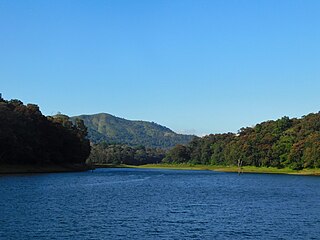
Thekkady Hill station in Kerala, India

Thekkady(Idukki district) is a town near Periyar National Park, an important tourist attraction in the Kerala state of India. The named Thekkady is derived from the word "thekku" which means teak. Temperatures are lowest in the months of December-January and highest in the months of April-May.

Koottickal Village in Kerala, India

Koottickal is a town at the base of Western Ghats mountain ranges in the Kottayam district, Kerala. It is 2,000 feet (610 m) above sea level and is situated on the eastern border of Kottayam District, 55 km from Kottayam, and around 5 km away from Mundakayam on the NH 220. There are streams and waterfalls in the surrounding places. The Muthukora Hills are nearby. Urban centres in Kottayam and Ernakulam districts can be viewed from the top of Muthukora Hills.

Vagamon Hill station in Kerala, India

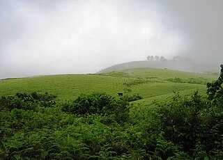
Vagamon is an Indian hill station and a revenue village primarily located in Peerumedu taluk of Idukki district, and also Meenachil taluk and Kanjirappally taluk of Kottayam district in the state of Kerala, India... Gifted with magnificent hill formations, natural attractions and panoramic views Vagamon has emerged as a major tourist destination in the recent times comparable with places like Munnar and Kumarakam in popularity.

Peermade Hill station in Kerala, India

Peermade, also spelt Peerumedu is a village, Grama Panchayat and hill station in the state of Kerala, India. It lies 915 metres (3,002 ft) above sea level in the Western Ghats (Sahyadri) about 85 kilometres (53 mi) east of Kottayam on the way to Thekkady through the nearby city of Kanjirappally.

Kuttikkanam Hill station in Kerala, India

Kuttikkanam, is a hill station in Idukki district, Kerala, southern India. It is 3,500 feet (1,100 m) above sea level and surrounded by lush green tea plantations. It is within the territory of Peermade. Kanjirappally and Mundakayam are the nearest towns.

Kumily Plantation Town in Kerala, India

Kumily also spelt as Kumaly is a revenue village and Gram Panchayat in the Idukki district of Kerala. It is a town in Cardamom Hills near Thekkady and Periyar Tiger Reserve. Kumily is a gateway town into Kerala from Tamil Nadu.

Ramakkalmedu Hill Station in Kerala, India

Ramakkalmedu is a hill station and a hamlet in Idukki district in the Indian state of Kerala. The place is noted for its panoramic beauty and numerous windmills.

Elappara Plantation township in Kerala, India

Elappara is a village in Idukki district in the Indian state of Kerala. It is one of the panchayaths in Peerumedu taluk. The area is marked by a cool climate as the region is situated at an elevation of more than 1,000 m (3,300 ft) above the sea level. Elappara is famous for its vast tea plantations.

Kanchiyar Tourist spot/village in Kerala, India

Kanchiyar is a village located in Idukki taluk of Idukki district Kerala, India. The place has a vast cardamon and pepper plantations. Anchuruli, one of the famous tourist spots in idukki is located in Kanchiyar panchayath. The main settlements in Kanchiyar are Kozhimala, Swaraj, Labbakkada, Thoppipala, Mattappally and Kakkattukada.

Parunthumpara village in Kerala, India

Parunthumpara is a village in the Indian state of Kerala's Idukki District. It is a small scenic location near Wagamon en route to Peerumedu. Parunthumpara is located 6 km from Peermade and 25 km from Thekkady. The Malayalam word parunth means eagle and para means rock. It is called Parunthumpara or "eagle rock" because of a large area around like an eagle.

Chenkara is a small village in Kothamanglam Ernakulam Kerala India. It is located on the bank of the Periyar. It is also near Bhoothathankettu, a tourist place in Kothamangalam.

Paloorkavu is a village in Peermade tehsil, Idukki district, Kerala, India. It consists of around 500 residences and one church and a temple which is located in the center of the village. A small river flows through this village. Nearby places include Thekkemala, Mundakkayam and Panchalimedu.

George Thengummoottil

George Thengummoottil is wildlife filmmaker and documentary editor, from India whose film has been screened at various International film festivals like Pokhara International Mountain Film Festival and International Documentary and Short Film Festival of Kerala. He is also the founder of Keratoconus Foundation India, a non profit organization which aims at helping Keratoconus patients.

Valliyamkavu Devi Temple

Valliyamkavu Devi Temple is a historic Durga shrine located near Travancore Rubber and Tea Company, 15 km (9.3 mi) east to 35th mile near Mundakkayam. The temple and its surroundings falls under the Peerumedu tehsil of Idukki district.

Nariampara Puthiyakavu Devikshethram

Nariampara Puthiyakavu Devikshethram is a Hindu temple located in Nariampara near Kattappana in Idukki district of Kerala state, India. The temple is situated on the Kattappana - Kuttikkanam state highway, about 3 km from Kattappana.

Pakshi Pathalam

Pakshi Pathalam is a Bird Sanctuary and a tourist location in Wayanad district of Kerala state, India.

Parathanam is a Town at the base of Western Ghats mountain ranges in the Kottayam district, Kerala. It is 2,000 feet above sea level and is situated on the eastern border of Kottayam District, 60 km from Kottayam, 12 km away from Poonjar and around 8 km away from Mundakayam on the NH 220.

References

  1. "Pachalimedu - BlessingsOnTheNet.com - destination › Panchalimedu". blessingsonthenet.com. Retrieved 5 December 2016.
  2. "Panchalimedu: Beyond a pit-stop". OnManorama. Retrieved 3 December 2016.
  3. "Panchalimedu: an idyllic spot less trodden". OnManorama. Retrieved 3 October 2019.
  4. "Panchalimedu - Near Kuttikkanam in Idukki district of Kerala". Panchalimedu. Retrieved 3 December 2016.
  5. The Story of Peermade, Peermade; George, Thengummoottil (2014). The Story of Peermade. George Thengummoottil. p. 59. ISBN   978-8192888606.
  6. "panchalimedu kuttikanam, parunthumpara kuttikkanam, peeru hills, travancore palace, pattumala church". www.dreamlandhillresort.com. Retrieved 3 December 2016.
  7. "Places To Visit - Kuttikanam Castle - kuttikanamcastle.com › placestovisit". kuttikanamcastle.com. Retrieved 5 December 2016.
  8. "The allure of magical Panchalimedu". The Hindu. 3 March 2009. ISSN   0971-751X . Retrieved 3 December 2016.
  9. "Panchalimedu". Kochi Taxi | Kerala Taxi | Kerala Tour Packages. 1 January 2016. Retrieved 3 December 2016.
  10. "Sabarimala Ayyappa Temple Calendar 2016 - 2017 - www.ayyappatemple.in › temple-calendar". www.ayyappatemple.in. Retrieved 5 December 2016.
  11. "Thekkady | Thekkay Kerala | Places in Thekkady | Periyar Wildlife Sanctuary | sanctuary watch towers | Kumily | Mangala Devi Temple | Chellarkovil | Vandiperiyar | Pullumedu | Grampi | Mullaperiyar Dam | Mundakayam | Panchali Medu | Valanjaganam Waterfalls | Peru hills | Amrithamedu Hills | Pallikkunnu | Vagamon | The Moonhill | Patumaala | Places in Thekkady | Thekkady". thekkady.kerala1.com. Retrieved 4 December 2016.
  12. "Panchalimedu, Hill Station". www.keralabeing.com. Retrieved 3 December 2016.
  13. "Peeru Hills near Kuttikanam, Idukki - Kerala Tourism - www.keralatourism.org › destination". www.keralatourism.org. Retrieved 5 December 2016.
  14. "Panchalimedu, Idukki". Kerala Trips. Retrieved 3 December 2016.
  15. "Valliyamkavu Devi temple - History". www.valliyamkavudevitemple.com. Retrieved 5 December 2016.
  16. "Peermede Tour - Thrisangu Hills - Summer Palace - Halo Backwaters - halokerala.com › destinations › peermede" . Retrieved 5 December 2016.
  17. "Panchalimedu - Home". panchalimedu.org. Retrieved 3 December 2016.
  18. "Panchalimedu-Idukki tourist places". Beautiful tourist places around Idukki. Retrieved 3 December 2016.
  19. "Panchalikulam - BizHat.com Photo Gallery - gallery.bizhat.com ›Panchalimedu". gallery.bizhat.com. Retrieved 5 December 2016.
  20. "Panchalimedu - About Panchali medu". panchalimedu.org. Retrieved 3 December 2016.
  21. "Nature Calling | Kattupara trekking". naturecalling.in. Retrieved 3 December 2016.
  22. "Newly-erected wooden crosses removed from Panchalimedu". New Indian express. Retrieved 22 February 2020.

https://instagram.com/panchalimedu?igshid=1qcw3kmcua989