Koruthodu

Last updated

Koruthodu
his
India Kerala location map.svg
Red pog.svg
Koruthodu
Location in Kerala, India
India location map.svg
Red pog.svg
Koruthodu
Koruthodu (India)
Coordinates: 9°28′0″N76°57′0″E / 9.46667°N 76.95000°E / 9.46667; 76.95000 Coordinates: 9°28′0″N76°57′0″E / 9.46667°N 76.95000°E / 9.46667; 76.95000
CountryFlag of India.svg  India
State Kerala
District Kottayam
Government
  BodyKoruthodu Grama Panchayath
Population
 (2008)
  Total21,470
Languages
  Official Malayalam, English
Time zone UTC+5:30 (IST)
PIN
686513
Telephone code04828
Vehicle registration KL-34
Nearest cityKottayam, Mundakayam.
Lok Sabha constituencyPathanamthitta
Civic agencyKoruthodu
Climate cool pleasant (Köppen)

Koruthodu is a village/town in Kanjirappally Taluk, Kottayam District of Kerala state, India. It is situated on the Highway connecting Mundakayam to Sabarimala temple, Kerala, and is at the border of Pathanamthitta, Kottayam and Idukki districts. The nearest town Mundakayam is 13 Kilometers from Koruthodu. The river Azhutha (Tributary of Pamba) runs through the borders of this village. Nearby locations include Kanamala, Vandanpathal, Mundakkayam and Panakkachira.

Kanjirappally Town in Kerala, India

Kanjirappally is a taluk and a town in Kottayam district situated about 38 km (24 mi) away from the district capital, in the state of Kerala, India. National Highway connects Kanjirapally to major nearest cities. Kanjirappally, also known as the Gateway of Highrange since it is the geographic entrance to the 'Malanad' or the Hill country of Kerala, which extends to Idukki district and then to Tamil Nadu. Kanjirapally is one of the most busiest towns in kottayam district. It is a part of the Palai city metro. A new airport has been proposed which is near to kanjirapally in Erumeli.

Kottayam City in Kerala, India

Kottayam is a prominent city in the Indian state of Kerala. It is the district headquarters of Kottayam district, located in south-west Kerala. It had a population of 136,812 in the city's administrative limits, according to the 2011 census. Kottayam is approximately 146 km north of Thiruvananthapuram, the capital city of Kerala.

Kerala State in southern India

Kerala is a state on the southwestern Malabar Coast of India. It was formed on 1 November 1956, following passage of the States Reorganisation Act, by combining Malayalam-speaking regions. Spread over 38,863 km2 (15,005 sq mi), Kerala is the twenty-third largest Indian state by area. It is bordered by Karnataka to the north and northeast, Tamil Nadu to the east and south, and the Lakshadweep Sea to the west. With 33,387,677 inhabitants as per the 2011 Census, Kerala is the thirteenth-largest Indian state by population. It is divided into 14 districts with the capital being Thiruvananthapuram. Malayalam is the most widely spoken language and is also the official language of the state.

Contents

Access

Mundakayam town in Kerala, India

Mundakayam, is a town in Kanjirappally Taluk in the Kottayam District of Kerala. It is the doorway to the high ranges of southern Kerala, and is at the border of Kottayam and Idukki districts. The next nearest town, Kanjirappally, is 14 km (8.7 mi) & Erumely is 12 km from Mundakayam. Mundakayam has rubber plantations, and greenery. The Manimala River runs through Mundakayam. It is located 48 km east of the district headquarters at Kottayam and 148 km from the state capital, Thiruvananthapuram. The name Mundakayam is said to be derived from the Mundi cranes that used to be seen along the Manimala River banks.

Sabarimala temple in Pathanamthitta District, Kerala, India

The Sabarimala temple is a temple complex located at Sabarimala inside the Periyar Tiger Reserve in Pathanamthitta district, Kerala, India. It is the site of the one of the largest annual pilgrimage in the world with an estimate of between 17 million and 50 million devotees visiting every year. The temple is dedicated to the Hindu celibate deity Ayyappan also known as Dharma Sastha, who according to belief is the son of Shiva and Mohini, the feminine incarnation of Vishnu. The traditions of Sabarimala are a confluence of Shaivism, Shaktism, Vaishnavism, and other Śramaṇa traditions.

Koruthodu is exactly 13 km South-East of Mundakayam Town. The State Highway connecting Mundakayam and Sabarimala passes through Koruthodu. Major cultivations are coffee, Tapioca, Banana, pepper, cocoa and natural rubber. [2]

Black pepper Piperaceae, cultivated for peppercorn

Black pepper is a flowering vine in the family Piperaceae, cultivated for its fruit, known as a peppercorn, which is usually dried and used as a spice and seasoning. When fresh and fully mature, it is about 5 mm (0.20 in) in diameter and dark red, and contains a single seed, like all drupes. Peppercorns and the ground pepper derived from them may be described simply as pepper, or more precisely as black pepper, green pepper, or white pepper.

Cocoa bean Fatty seed of Theobroma cacao which is the basis of chocolate

The cocoa bean or simply cocoa, which is also called the cacao bean or cacao, is the dried and fully fermented seed of Theobroma cacao, from which cocoa solids and cocoa butter can be extracted. Cocoa beans are the basis of chocolate, and Mesoamerican foods including tejate, a pre-Hispanic drink that also includes maize.

Sports and Games

Koruthodu can boast supreme legacy in Indian athletic history as Koruthodu C.K.M. School was National champions in athletics for 15 years under the guidance of Dhronacharya 'K.P.Thomas' mash. Famous Olympians like Anju Bobby George , Shiny Wilson , Joseph Abraham were found and nurtured here. [3]

Anju Bobby George Indian long jumper

Anju Bobby George is an Indian athlete. She is India's first and only World Champion in Athletics IAAF World Athletics Final. Anju Bobby George made history when she won the bronze medal in long jump at the 2003 World Championships in Athletics in Paris. With this achievement, she became the first Indian athlete ever to win a medal in a World Championships in Athletics jumping 6.70 m. She went on to win the gold medal at the IAAF World Athletics Final in 2005, a performance she considers her best. Anju was upgraded to the gold status from silver in the 2005 World Athletics Final in Monte Carlo following the disqualification of Tatyana Kotova of Russia by the International Association of Athletics Federations, following the recent re-testing of the latter’s sample collected at the 2005 World Championship in Helsinki. She was awarded the Arjuna Award in 2002. She had got 5th position with personal best score of 6.83 at the 2004 Athens Olympics.

Joseph Abraham Indian hurdler

Joseph Ganapathiplackal Abraham is an Indian track and field athlete from Kerala. He holds the current 400 metre hurdles State record of 49.51 seconds set during the 2007 World Championships in Athletics in Osaka on 26 August 2007. At Osaka, Abraham became the first Indian male athlete to clear the opening round of an event in the World Athletics Championships when he reached the 400m hurdles semifinals. He also won the 400m hurdles gold medal at 2010 Guangzhou Asian Games.

Nearest Airport

Cochin International Airport

See also

Related Research Articles

Koottickal Village in Kerala, India

Koottickal is a Town at the base of Western Ghats mountain ranges in the Kottayam district, Kerala. It is 2,000 feet (610 m) above sea level and is situated on the eastern border of Kottayam District, 55 km from Kottayam, and around 5 km away from Mundakayam on the NH 220. There are streams and waterfalls in the surrounding places. The Muthukora Hills are nearby. Urban centres in Kottayam and Ernakulam districts can be viewed from the top of Muthukora Hills.

Ponkunnam Town in Kerala, India

Ponkunnam is a census town in the eastern high-ranges of Kerala, India, part of Kottayam district under Kanjirappally Taluk. Ponkunnam literally means 'The Town on a Golden mountain

Kumily Plantation Town in Kerala, India

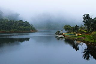
Kumily is the largest Gram Panchayat in the Idukki district of Kerala. It is a town in Cardamom Hills near Thekkady and Periyar Tiger Reserve. Kumily is gateway town in Kerala to Tamil Nadu.

Mallikassery Village in Kerala, India

Mallikassery is a small village near Paika, in Elikulam Panchayat of Kanjirappally Taluk in Kottayam district, in the state of Kerala, India.

Erumely Town/village in Kerala, India

Erumely, also spelt "Erumeli" is a village and town in the southeast part of Kottayam district in Kerala state, India. It is situated on the way to Sabarimala and also an important halting place (idathavalam) for the Sabarimala pilgrims. Erumely is famed for its religious harmony and prosperity between Hindus and Muslims which existed from the early periods. It is a place which have strong roots in legends and myths associated with lord Ayyappa. A new airport has been proposed in Erumeli. The city is nourished by Manimala River.

Cheruvally village in Kerala, India

Cheruvally is a Village in Chirakkadavu panchayat of Kottayam district in Kerala. It is in Kanjirappally taluk, Kottayam district. Name of the place is derived from the myth related to cheruvally temple. Kerala govt and central govt gave approval to construct airport for Sabarimala at Cheruvally Estate near Erumeli. The proposed Sabarigiri International Airport in Central Travancore is to come up on the 2263 acre Cheruvally estate, 2.5 km from the Theni-Kottarakara National Highway and close to Erumeli town in Kottayam district and is about 48 km from Sabarimala. Cheruvally Estate is close to two NH corridors and five PWD roads.A ₹2,500-crore greenfield airport to be developed by a joint venture of Non-Resident Indians.The GIA had also floated a company, Indo-Heritage International Aeropolis Pvt. Ltd. (IHIAPL), for executing the project and opened its office in Pathanamthitta. Besides catering to the needs of the flyers in Central Travancore, the airport is expected to reduce the heavy traffic on the roads leading to Sabarimala during the pilgrim season. Pilgrims alighting at the Chengannur and Thiruvalla railway stations reach Sabarimala through various routes linked to M.C. Road or National Highway.

Kodungoor town in Kerala, India

Kodungoor is a small town in Kottayam district of Kerala state in India and is popularly known as "Vazhoor". Kodungoor is 25 km from the district headquarters, Kottayam, 29 km from Changanassery, 7 km from Ponkunnam, 9 km from Pampady and 13 km from Kanjirappally. The Kottayam-Kumaly road passes through the town. NH 220 splits into two just after Kodungoor: one goes in the direction of Changanassery and another towards Kottayam.

Mukkoottuthara Town/village in Kerala, India

Mukkoottuthara is a developing Town located in the south eastern part of Kottayam district of Kerala State, India. Sabarimala is only 48 km (30 mi) from Erumely, while travelling through Mukkoottuthara. The roads passing through here are upgraded and maintained as State Highways. The main cultivation is rubber. Mukkoottuthara is famous for its decades old "Sunday Open Markets" and for its famous bamboo products. One of the famous tourist spots in Pathanamthitta, Perunthenaruvi Falls is just 5 kilometers from Mukkoottuthara. There are many rubber estates. The border of Kottayam and Pathanamthitta divides Mukkoottuthara into two. However the place is recorded as part of Kottayam district only.

Main Eastern Highway road in Kerala, India

The Main Eastern Highway is the lifeline of the high range townships of the Travancore region of Kerala state, India. It is also known as Punalur-Pathanamthitta-Palai-Thodupuzha-Muvattupuzha Highway. Main Eastern Highway is categorized as State Highway - 08 of Kerala. It is the second longest State Highway of Kerala covering a distance of 153.6 km. The districts it passes through are Kollam, Pathanamthitta, Kottayam, Idukki and Ernakulam.

State Highway 7 (Kerala) road in Kerala, India

The SH-07 / T.K.Road is the life line of the Central Travancore.

Gavi, Kerala Village in Kerala, India

Gavi is a village in Pathanamthitta district, Kerala, India. It is located 28 km southwest of Vandiperiyar, a town in Idukki on N.H 220, the highway connecting Kollam and Madurai.

National Highway 183 (India) national highway in India

National Highways 183 is located in India. It connects Kollam in Kerala with Dindigul in Tamil Nadu. Starting from NH 66 in Kollam city – The Cashew Capital of the World, it runs northwards and turns east at Kottayam and runs along the northern border of Periyar Wildlife Sanctuary before crossing the border into Tamil Nadu and end near Dindigul, where it joins NH 83(Coimbatore - Nagapattinam). This highway was previously known as NH 220.

Thulappally village in Kerala, India

Thulappally is a small village in Perunad panchayath of Ranni tehsil in Pathanamthitta district of Kerala state, India..

Sabarimala Railway is a proposed 111 kilometres (69 mi) railway line from Angamaly to Erumeli, near Sabarimala that has been sanctioned in the year 1998 by Indian Railways. According to a Memorandum of Understanding (MoU) signed between the Kerala State and the Ministry of Railways on 27 January 2016, commercially viable railway projects will be identified and handed over to the Special Purpose Vehicle (SPV) to be fast-tracked on a 51:49 per cent equity basis. SPV has discussed about the extension to Punalur. The currently proposed Sabarimala railway is under PMO - Pro active governs and timely implementation (Pragati); will be monitored by the Prime Minister's Office. Another proposal for this railway line is extend to Trivandrum Central. If this proposed Sabarimala railway is connected to proposed new railway terminal at Nemom near Trivandrum Central via Nedumangad, several long distance trains are supposed to be operated from Nemom Terminal via Punalur ,Nedumangad and Angamaly to Chennai/Bangalore and rest of country. Survey for new lines from Madurai Junction to Kottayam and Dindigul Junction to Cumbum lower camp, Kumily to Sabarimala, ettumanoor to pala also started.

Kanamala village in Kerala, India

Kanamala, commonly known by the name Pambavalley, is a village in Erumely panchayath in Kanjirappally tehsil of Kottayam district in the Indian state of Kerala. It is situated in the border of Kottayam and Pathanamthitta districts, but officially recorded as a part of Kottayam district only.

Punchavayal village in Kerala, India

Punchavayal is a village in Mundakayam panchayath of Kanjirappally taluk in the Indian state of Kerala. An Aided Arts and science college is present in this village. Punchavayal includes the places nearby Murikkumvayal, Pachima, Pakkanam, Kadamanthode, Kulamakkal and Moonnoly. It is approximately 6 km away by road from Mundakayam the doorway to the high ranges of southern Kerala, and is at the border of Kottayam and Idukki districts.

Sabarigiri International Airport

Sabarigiri Airport or Kottayam Airport is a proposed airport project to be built for the Central Travancore as well as the Sabarimala Pilgrims at Cheruvally Estate in Manimala panchayath, Kanjirappally Taluk near Erumely of Kottayam district, Kerala in India. Kerala govt gave approval to construct airport for Sabarimala at Cheruvally Estate near Erumely. It is a table top plateau airport and with vast scope for further expansion. It also requires minimal capital and maintenance cost given strong soil and topography.

The Kottayam–Kumily Road, better known as K K Road is the State Highway connecting Kottayam and Idukki districts of Kerala state, India. It is designated as State Highway 13 by the Kerala Public Works Department. It shares its route with National Highway 183 (NH 183), and it is 107.9 kilometres (67.0 mi) long.

References

  1. "PWD Roads Kottayam". keralapwd.gov.in. Retrieved 11 February 2015.
  2. "കോരുത്തോട് ഗ്രാമപഞ്ചായത്ത് (Koruthodu Grama Panchayat)". lsgkerala.in. Retrieved 11 February 2015.
  3. "The true DRONACHARYA - The Hindu". thehindu.com. Retrieved 11 February 2015.