Pannonia (Byzantine province)

Last updated
Pannonia
Provincia Pannonia
επαρχία Παννονία
Province of the Byzantine Empire
c. 510–580s
Balkans 6th century.svg
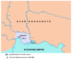
The Byzantine northern Balkans in the 6th century. The province of Pannonia is located in the northwestern corner of imperial territory.
Capital Sirmium
History
History 
 Established
c. 510
 Sirmium given to Gepids
536
580-582
 Partition with the Avars
580s
Succeeded by
Avar Khaganate Blank.png
Today part of Serbia
Map of the Byzantine Pannonia Byzantine pannonia en.png
Map of the Byzantine Pannonia

Pannonia was a Byzantine province, which existed in present-day Syrmia region of Serbia in the 6th century. Its capital was Sirmium (modern-day Sremska Mitrovica).

Contents

It differed significantly in its area from the Roman province of Pannonia, and it was subordinate to the Diocese of Dacia.

Geography

The province was located between the Danube river in the north-east and Sava river in the south. The western border of Byzantine Pannonia stretched approximately to the estuary or river Drina into Sava. Important cities in the area were Sirmium and Bassianae. Byzantine Pannonia bordered Byzantine province of Moesia Prima in the south and Avar Khaganate in the west, north and east.

History

Background

Byzantine Pannonia succeeded the name of much bigger classical Roman province of Pannonia. In other words, The Byzantine one covered only a small eastern part of ancient Roman Pannonia. In the 2nd century, the original Roman province was divided into two ones: Pannonia Inferior and Pannonia Superior. Subsequently, the area was subdivided into four provinces finally: Pannonia Prima, Pannonia Valeria, Pannonia Savia and Pannonia Secunda. Capital of Pannonia Secunda was Sirmium.

In the middle of the 5th century, the territory of former Roman Pannonia was ceded to the Huns by Theodosius II, and after the death of Attila it successively passed (entirely or partially) into the hands of the Ostrogoths, Lombards and Gepids.

A contract from 510 assigned most of the territory of former Roman Pannonia (including Sirmium) to the Ostrogoths, while the eastern part of present-day Syrmia (which included the city of Bassianae) was assigned to the Byzantine Empire. In 536, Sirmium was placed under the control of the Gepids. The Lombard–Gepid War (567) ended with a Lombard-Avar victory and annihilation of Gepids, while Sirmium was retaken by the Byzantine Empire. [1]

Under the Byzantine Empire

From 567 to 573, the Byzantine Empire was in a war with the Avars, who aimed to conquer Byzantine Pannonia. Temporary truce was declared in 573, but the war was resumed. Due to the fact that Byzantine-Persian war also started in this time, the Byzantine Empire was not able to defend Pannonia. The city of Sirmium was finally conquered by the Avars in 582, thus marking end of Roman control of Pannonia since Classical Antiquity.

Legacy

The Byzantine Empire re-established control over Pannonia in the 11th century, leading to the creation of the Theme of Sirmium to administer the region, but not lasting long.

Related Research Articles

<span class="mw-page-title-main">Gepids</span> Germanic tribe

The Gepids were an East Germanic tribe who lived in the area of modern Romania, Hungary and Serbia, roughly between the Tisza, Sava and Carpathian Mountains. They were said to share the religion and language of the Goths and Vandals.

<span class="mw-page-title-main">Vojvodina</span> Northernmost Autonomous province of Serbia

Vojvodina, officially the Autonomous Province of Vojvodina, is an autonomous province that occupies the northernmost part of Serbia. It lies within the Pannonian Basin, bordered to the south by the national capital Belgrade and the Sava and Danube Rivers. The administrative center, Novi Sad, is the second-largest city in Serbia.

<span class="mw-page-title-main">Petrovaradin</span> Town in Vojvodina, Serbia

Petrovaradin is a historic town in the Serbian province of Vojvodina, now a part of the city of Novi Sad. As of 2011, the urban area has 14,810 inhabitants. Lying on the right bank of the Danube, across from the main part of Novi Sad, it is built around the Petrovaradin Fortress, the historical anchor of the modern city.

<span class="mw-page-title-main">Sremska Mitrovica</span> City in Vojvodina, Serbia

Sremska Mitrovica is a city and the administrative center of the Srem District in the autonomous province of Vojvodina, Serbia. It is situated on the left bank of the Sava river. As of 2011, the city has a total population of 37,751 inhabitants, while its administrative area has a population of 79,940 inhabitants.

<span class="mw-page-title-main">Syrmia</span> Geographical region of Serbia and Croatia

Syrmia is a region of the southern Pannonian Plain, which lies between the Danube and Sava rivers. It is divided between Serbia and Croatia. Most of the region is flat, with the exception of the low Fruška gora mountain stretching along the Danube in its northern part.

<span class="mw-page-title-main">Srem District</span> District of Serbia

The Srem District is one of seven administrative districts of the autonomous province of Vojvodina, Serbia. It lies in the geographical regions of Syrmia and Mačva. According to the 2022 census results, it has a population of 282,547 inhabitants. The administrative center is the city of Sremska Mitrovica.

<span class="mw-page-title-main">Sirmium</span> Roman and Byzantine city

Sirmium was a city in the Roman province of Pannonia, located on the Sava river, on the site of modern Sremska Mitrovica in the Vojvodina autonomous provice of Serbia. First mentioned in the 4th century BC and originally inhabited by Illyrians and Celts, it was conquered by the Romans in the 1st century BC and subsequently became the capital of the Roman province of Pannonia Inferior. In 294 AD, Sirmium was proclaimed one of four capitals of the Roman Empire. It was also the capital of the Praetorian prefecture of Illyricum and of Pannonia Secunda. The site is protected as an archaeological Site of Exceptional Importance. The modern region of Syrmia was named after the city.

<span class="mw-page-title-main">Mačva</span> Geographical and historical region of Serbia

Mačva is a geographical and historical region in the northwest of Central Serbia, on a fertile plain between the Sava and Drina rivers. The chief town is Šabac. The modern Mačva District of Serbia is named after the region, although the region of Mačva includes only the northern part of this district. A small northern part of Mačva region is in the Autonomous Province of Vojvodina, in the Syrmia District.

Bayan I reigned as the first khagan of the Avar Khaganate between 562 and 602.

Vojvodina is an autonomous province that comprises northern Serbia. It consists of the southern part of the Pannonian Plain, mostly located north from the Danube and Sava rivers.

<span class="mw-page-title-main">Pannonia Secunda</span> Roman province (296 - mid-5th century)

Pannonia Secunda was one of the provinces of the Roman Empire. It was formed in the year 296, during the reign of emperor Diocletian. The capital of the province was Sirmium. Pannonia Secunda included parts of present-day Serbia, Croatia, and Bosnia and Herzegovina.

<span class="mw-page-title-main">Sirmium (theme)</span>

The Theme of Sirmium was a Byzantine administrative unit (theme), which existed in present-day Serbia, Croatia and Bosnia and Herzegovina in the 11th century. Its capital was Sirmium.

<span class="mw-page-title-main">Donji Petrovci</span> Village in Vojvodina, Serbia

Donji Petrovci is a village in Serbia. It is situated in Ruma municipality, Srem District, Vojvodina province. The village has a Serb ethnic majority and a population of 991 people. There is a significant ancient Roman archaeological site near the village - the remains of large city Bassianae, which in the 3rd century had the highest status of colonia.

<span class="mw-page-title-main">Bassianae</span> Ancient Roman town

Bassianae or Bassiana was an important ancient Roman town in Pannonia. It was located near present-day Donji Petrovci, a village in the Ruma municipality. Bassianae was the second largest town in Syrmia, after Sirmium. It was located on a road that connected Sirmium and Singidunum.

<span class="mw-page-title-main">Serbia in the Roman era</span>

Much of the territory of the modern state of Serbia was part of the Roman Empire and later the Eastern Roman Empire. In particular, the region of Central Serbia was under Roman rule for about 800 years, starting from the 1st century BC, interrupted by the arrival of the Slavs into the Balkans during the 6th century, but continued after fall of the First Bulgarian Empire in the early 11th century and permanently ended with the rise of the Second Bulgarian Empire in the late 12th century. The territories were administratively divided into the provinces of Moesia, Pannonia and Dardania. Moesia Superior roughly corresponds to modern Serbia proper; Pannonia Inferior included the eastern part of Serbia proper; Dardania included the western part of Serbia proper. After its reconquest from the Bulgarians by Emperor Basil II in 1018, it was reorganized into the Theme of Bulgaria.

Thurisind was king of the Gepids, an East Germanic Gothic people, from c. 548 to 560. He was the penultimate Gepid king, and succeeded King Elemund by staging a coup d'état and forcing the king's son into exile. Thurisind's kingdom, known as Gepidia, was located in Central Europe and had its centre in Sirmium, a former Roman city on the Sava River.

<span class="mw-page-title-main">Posavina</span>

Posavina is a geographical region that stretches along the Sava river, encompassing only the inner areas of the Sava river basin, that are adjacent or near to the Sava river itself, namely catch region spanning from the Julian Alps in the northwest to the confluence with the Danube in the southeast. It passes through several countries of former Yugoslavia, namely Slovenia, Croatia, Bosnia and Herzegovina and Serbia. In Slovene, the term Posavina is not used to describe the parts of Slovenia that lie by the Sava river. Instead, the terms Posavje and Zasavje are used.

<span class="mw-page-title-main">Moesia Prima</span>

Moesia Prima was a frontier province of the late Roman Empire, situated in the central parts of present-day Serbia, along the south bank of the Danube River. Provincial capital was Viminacium, near modern Kostolac in Serbia).

<span class="mw-page-title-main">Timeline of Hungarian history</span>

The timeline of Hungarian history lists the important historical events that took place in the territory of Hungary or are closely connected to the history of the country.

References

  1. Collins, Roger (2010). Early Medieval Europe, 300-1000. Palgrave Macmillan. p. 201. ISBN   978-1-137-01428-3.

See also