Parabiago

Last updated
Parabiago
Parabiagh (Lombard)
Città di Parabiago
Parabiagocollage.jpg
Clockwise from top: Villa Ida Lampugnani-Gajo; ornamental tower in a lombard court; a roggia with the "Madonna di Dio il Sà" church in the background; and via San Michele with the church of San Michele in the background
Parabiago-Stemma.gif
Nickname: 
The City of Footwear
Location of Parabiago
Parabiago
Italy provincial location map 2016.svg
Red pog.svg
Parabiago
Location of Parabiago in Italy
Italy Lombardy location map.svg
Red pog.svg
Parabiago
Parabiago (Lombardy)
Coordinates: 45°33′N08°57′E / 45.550°N 8.950°E / 45.550; 8.950
Country Italy
Region Lombardy
Metropolitan city Milan (MI)
Government
  MayorRaffaele Cucchi
Area
[1]
  Total14.16 km2 (5.47 sq mi)
Elevation
184 m (604 ft)
Population
 (28 February 2017) [2]
  Total27,723
  Density2,000/km2 (5,100/sq mi)
Demonym Parabiaghesi
Time zone UTC+1 (CET)
  Summer (DST) UTC+2 (CEST)
Postal code
20015
Dialing code 0331 (Busto Arsizio Code)
Patron saintSt. Gervasius and Protasius
Saint day19 June
Website Official website
St. Gervasius and Protasius Church Pbg Prepositurale 2.jpg
St. Gervasius and Protasius Church

Parabiago (Milanese: Parabiagh; Latin : Parabiacum) is a town located in the north-western part of the Metropolitan City of Milan, Lombardy, northern Italy.

Contents

The Maggi-Corvini Villa Pbg Corvini 01.jpg
The Maggi-Corvini Villa

The town is crossed by the road to Sempione (S.S.33) and Milan   Gallarate Railway; nearby flow the Olona river and the Canale Villoresi.

History

Ancient history and Middle Ages

Starting from the first Celtic-insubrian settlement (4th century BC), it developed during the Roman Empire rule, as documented by various archaeological discoveries of little objects, including the Parabiago Plate, a silver plate probably used to cover an ashes urn.

In the Early Middle Ages, Parabiago was the centre of a parish (pieve) and of an autonomous county, named Comitatus Parabiagi and sometimes Burgaria, governed by the Sanbonifacio family, of Frankish descent, coming from Verona; in the 7th century, it received by the Lombard queen Theodelinda the permission for a little artificial stream, named Riale or Röngia, which took water from the Olona river and travelled through the village: that stream lasted until the 1928, when it was definitively stilted up.

The Truce of Parabiago (28 29 August 1257) led to the Pace di Sant'Ambrogio (Saint Ambrose's Peace), so called because it was signed in the homonymous Basilica in Milan). It put an end to the risk of a civil war between nobles and people in the free commune of Milan. On 21 February 1339, it was the location of the Battle of Parabiago between Lodrisio Visconti and Luchino Visconti with his nephew Azzone, for the dominion over the Duchy of Milan; the battle was won by the Milanese regular army; according to tradition, this happened thanks to the miraculous apparition of Saint Ambrose. During this time, the Crivelli family inherited from the Sanbonifacio family the County of Parabiago, perhaps still corresponding with the Burgaria County.

In the following centuries Parabiago had a slow decline; it suffered two pillages, in 1449 by Francesco Sforza and in 1527 by Bourbons of Spain, as well as two epidemics (1529 and 1540).

Modern Age

The Castelli Palace, called la Torre ("the Tower") Pbg la Torre 4.jpg
The Castelli Palace, called la Torre ("the Tower")

During Spanish rule in the Duchy of Milan, the Marquis Camillo Castelli bought the Fief of Parabiago for 8800 lire (26 September 1658); the family extinguished in 1783, with the death of Cardinal Giuseppe Castelli.

Parabiago developed in the 18th century, during the Austrian rule. Between the 19th and 20th centuries the Industrial Revolution reached Parabiago. The most active industrialists were Felice Gajo, who established the Unione Manifatture di Parabiago (United Manufacturing of Parabiago) (textiles), and Paolo Castelnuovo, who founded in 1899 the first shoe factory in the town. Since then, Parabiago is known as the Città della Calzatura (Shoes City).

20th century

In the 1960s Parabiago like other cities and towns in Northern Italy experienced an economic boom followed by a demographic one. Industrialization caught on, the little traditional shoemakers established middle and big shoe factories; chemical and mechanical industries were born, and attracted immigration from Southern Italy. On 27 November 27, 1985 the town took the title of City.

In the early 1990s the majority of the Town Council, formed by D.C. (Christian Democracy), P.S.I. (Italian Socialist Party) and P.R.I. (Italian Republican Party), was forced to resign by the Tangentopoli scandal about the new urbanistic plan, and some important local politicians were arrested.

Transport

In the district there is one stop of Metro Line S5, even if there is a project of the construction of another stop near the border with Nerviano Bourough. One Regional Railway station operated by Trenord is present in the city. Some Movibus (local bus lines) link the town with other boroughs.

International relations

Parabiago is twinned with:

Sources

Related Research Articles

<span class="mw-page-title-main">Visconti of Milan</span> Milanese noble family

The Visconti of Milan are a noble Italian family. They rose to power in Milan during the Middle Ages where they ruled from 1277 to 1447, initially as Lords then as Dukes, and several collateral branches still exist. The effective founder of the Visconti Lordship of Milan was the Archbishop Ottone, who wrested control of the city from the rival Della Torre family in 1277.

<span class="mw-page-title-main">Duchy of Milan</span> Former duchy in Italy (1395–1447; 1450–1796)

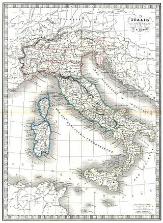
The Duchy of Milan was a state in Northern Italy, created in 1395 by Gian Galeazzo Visconti, then the lord of Milan, and a member of the important Visconti family, which had been ruling the city since 1277.

<span class="mw-page-title-main">Legnano</span> Comune in Lombardy, Italy

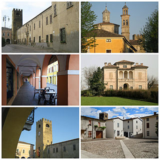
Legnano is an Italian town and comune in the north-westernmost part of the Province of Milan, about 20 kilometres (12 mi) from central Milan. With 60,259, it is the thirteenth-most populous township in Lombardy. Legnano is located in the Alto Milanese and is crossed by the Olona river.

<span class="mw-page-title-main">Castel Goffredo</span> Comune in Lombardy, Italy

Castel GoffredoItalian pronunciation:[kaˈstɛlɡofˈfreːdo] is a comune in the province of Mantua, in Lombardy, northern Italy, 35 kilometres (22 mi) from Mantua and a few more from Brescia. It lies in a region of springs at the foot of the slopes that drain into Lake Garda, towards the plain of the Po. Castel Goffredo borders the following municipalities: Castiglione delle Stiviere, Medole, Ceresara, Casaloldo, Asola, Acquafredda, Carpenedolo.

<span class="mw-page-title-main">Rho, Lombardy</span> Comune in Lombardy, Italy

Rho is a town and comune (municipality) in the Metropolitan City of Milan in the Italian region of Lombardy, located about 14 kilometres northwest of Milan. The language spoken in Rho is Italian.

<span class="mw-page-title-main">Albairate</span> Comune in Lombardy, Italy

Albairate is a comune (municipality) in the Metropolitan City of Milan in the Italian region Lombardy, located about 20 kilometres (12 mi) southwest of Milan.

<span class="mw-page-title-main">Castano Primo</span> Comune in Lombardy, Italy

Castano Primo is a city and comune in Province of Milan, in the Italian region Lombardy, located about 35 kilometres northwest of Milan.

Cerro Maggiore is a comune (municipality) in the Province of Milan in the Italian region Lombardy, located about 20 kilometres (12 mi) northwest of Milan.

Rescaldina is a comune (municipality) that is part of the Metropolitan City of Milan, in the Province of Milan in the Italian region Lombardy, with a population of 14,211 distributed over about 8 km2, and located about 25 kilometres (16 mi) northwest of Milan.

<span class="mw-page-title-main">San Donato Milanese</span> Comune in Lombardy, Italy

San Donato Milanese is a comune (municipality) in the Metropolitan City of Milan in the Italian region Lombardy, located about 10 kilometres (6 mi) southeast of Milan. It is served by the San Donato underground station right on the borderline between the town and Milan and by the San Donato Milanese railway station, serving only trains for the Trenord S1 line "Saronno–Lodi" and vice versa.

San Giorgio su Legnano is a comune (municipality) in the Metropolitan City of Milan in the Italian region Lombardy, located about 20 kilometres (12 mi) northwest of Milan.

<span class="mw-page-title-main">Casorate Primo</span> Comune in Lombardy, Italy

Casorate Primo is a comune (municipality) in the Province of Pavia in the Italian region Lombardy, located about 20 kilometres (12 mi) southwest of Milan and about 20 kilometres (12 mi) northwest of Pavia.

<span class="mw-page-title-main">Battle of Parabiago</span> 1339 battle in Italy

The Battle of Parabiago was fought in February 1339 near Parabiago, in Lombardy, northern Italy, between the Milanese army and the St. George's Mercenaries of Lodrisio Visconti. A renowned condottiero, the latter was an exiled member of the Visconti family then in power in Milan with a kind of triumvirate formed by Azzone and his uncles, Luchino and Archbishop Giovanni Visconti. Aiming to return victoriously to his city, he hired some 2,500 knights, mainly from Germany, and 1,000 Swiss infantry which had fought in the unsuccessful war of Mastino II della Scala for the hegemony in northern Italy. These units were led by Werner von Urslingen and Konrad von Landau.

<span class="mw-page-title-main">Corbetta, Lombardy</span> Comune in Lombardy, Italy

Corbetta is a comune (municipality) in the Metropolitan City of Milan in the Italian region Lombardy.

<span class="mw-page-title-main">Olona</span> River in Italy

The Olona is an Italian river belonging to the Po Basin, 71 kilometres (44 mi) long, that runs through the Province of Varese and Metropolitan City of Milan whose course is developed entirely in Lombardy.

<span class="mw-page-title-main">History of Milan</span> Aspect of history

Milan, Italy is an ancient city in northern Italy first settled in about 400 BC by Celtic Insubres. The settlement was conquered by the Romans in 222 BC and renamed it Mediolanum. Diocletian divided the Roman Empire, choosing the eastern half for himself, making Milan the seat of the western half of the empire, from which Maximian ruled, in the late 3rd and early 4th century AD. In 313 AD Emperors Constantine and Licinius issued the Edict of Milan, which officially ended the persecution of Christians. In 774 AD, Milan surrendered to Charlemagne and the Franks.

<span class="mw-page-title-main">Visconti Castle (Massino)</span>

The Visconti Castle of Massino is a medieval castle located on the Vergante hills in the municipality of Massino Visconti, Province of Novara, Piedmont, northern Italy. Since the 12th century it has been a possession and one of the preferred residences of the Visconti of Milan. At that time it was frequented by the family ancestor of the lords and dukes of Milan. Afterwards its property was transferred to other collateral branches of the lineage, from the initial Visconti di Massino to the current Visconti di San Vito.

<span class="mw-page-title-main">Flag of Lombardy</span>

The flag of Lombardy is one of the official symbols of the region of Lombardy, Italy. The current flag was officially adopted on 4 February 2019, although it has been used de facto since 12 June 1975.

<span class="mw-page-title-main">Visconti Castle (Fagnano Olona)</span>

The Visconti Castle of Fagnano is a castle located in Fagnano Olona, Lombardy, northern Italy. It lies at the border between the town of Fagnano and the Olona valley.

<span class="mw-page-title-main">Visconti Castle (Legnano)</span>

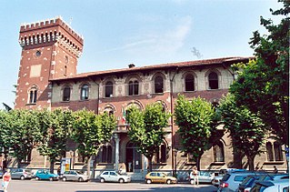
The Visconti Castle of Legnano is a mediaeval castle, located south of the city of Legnano, Metropolitan City of Milan, Lombardy, northern Italy. It lies on a small island formed by the Olona river. Since the 13th century, it is also known as the castle of San Giorgio.

References

  1. "Superficie di Comuni Province e Regioni italiane al 9 ottobre 2011". Italian National Institute of Statistics. Retrieved 16 March 2019.
  2. "Popolazione Residente al 1° Gennaio 2018". Italian National Institute of Statistics. Retrieved 16 March 2019.
  3. (in Italian) Parabiago-Samobor
  4. (in Italian)