
Jornada del Muerto was the name given by the Spanish conquistadors to the Jornada del Muerto desert basin, and the almost waterless 90-mile (140 km) trail across the Jornada beginning north of Las Cruces and ending south of Socorro, New Mexico. The name translates from Spanish as "Dead Man's Journey" or "Route of the Dead Man". The trail was part of the Camino Real de Tierra Adentro which led northward from central colonial New Spain, present-day Mexico, to the farthest reaches of the viceroyalty in northern Nuevo México Province.
Paraje, a Spanish term meaning in English place or spot. Paraje is a term from the original Spanish speaking settlers, in use among English speakers in the southwestern United States, particularly in New Mexico, that refers to a camping place along a long distance trail where travelers customarily stopped for the night. A paraje can be a town, a village or pueblo, a caravanserai, or simply a good location for stopping.

El Camino Real de Tierra Adentro, also known as the Silver Route, was a Spanish 2,560-kilometre-long (1,590 mi) road between Mexico City and San Juan Pueblo, New Mexico, that was used from 1598 to 1882. It was the northernmost of the four major "royal roads" that linked Mexico City to its major tributaries during and after the Spanish colonial era.
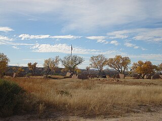
Fort Selden was a United States Army post, occupying the area in what is now Radium Springs, New Mexico. The site was long a campground along the El Camino Real de Tierra Adentro. It was the site of a Confederate Army camp in 1861. The U.S. Army established Fort Selden in 1865 for the purpose of protecting westward settlers from Native American raids, but the post fell into disrepair after the American Civil War. It was ultimately abandoned in 1891, due in large part to the decision to expand Fort Bliss and the lack of any expenditures for repair of the facility.

Fort Craig was a U.S. Army fort located along El Camino Real de Tierra Adentro, near Elephant Butte Lake State Park and the Rio Grande in Socorro County, New Mexico.
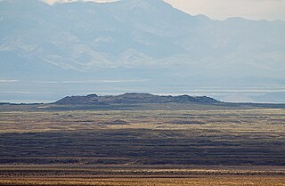
The Jornada del Muerto Volcano is a small shield volcano and lava field in central New Mexico, about 10 by 15 miles in size and reaching an elevation of 5,136 feet (1,565 m). Jornada del Muerto means "Dead Man's Route" in Spanish, referring to the desolate colonial era trail from New Spain through this Malpaís region.
The New Mexico State Register of Cultural Properties is a register of historic and prehistoric properties located in the state of New Mexico. It is maintained by the New Mexico Historic Preservation Division of the New Mexico Department of Cultural Affairs. The Cultural Properties Review Committee meets at least six times a year. The committee lists properties in the State Register and forwards nominations to the National Register.
Engle is an unincorporated community in Sierra County, New Mexico.
San Diego Mountain also known as Tonuco Mountain is an American summit 22 miles northwest of Las Cruces, New Mexico in Doña Ana County. Its summit is at an elevation of 4,951 feet.
Paraje de San Diego was a camping place, overlooking the Rio Grande, along the route of the Jornada del Muerto. It was located 5 leagues north of the Paraje de Robledo and "half a league from the river".
Lava Gate is an narrow area in the Jornada del Muerto, in the southern part of Socorro County, New Mexico. The Lava Gate creates a gap that trends north northwest to south southwest, between the malpaís of the Jornada del Muerto Volcano to the northeast and the foothills of the Fra Cristobal Range to the southwest. Its midpoint lies at an elevation of 4,573 feet. The Lava Gate provided a path for the Camino Real de Tierra Adentro from the interior of the Jornada del Muerto to the Rio Grande at Paraje, Socorro County, New Mexico.
Point of Rocks, named by the Spanish Cerros del Perrillo, is a 5,115 foot / 1,559 meter summit and the name of a range of hills of which the summit is the highest. The summit and the hills are in the Jornada del Muerto plateau, mostly in Sierra County, New Mexico. The southernmost part of the hills are within Doña Ana County, New Mexico.
Fort McRae was a Union Army post, established in 1863, then a U.S. Army post from 1866 and closed in 1876, in what is now Sierra County, New Mexico. The post was named for Alexander McRae (1829–1862) a slain hero of the 1862 Battle of Valverde.
Paraje del Perrillo, was a dependable watering and stopping place along the Camino Real de Tierra Adentro, where it passed through the Jornada del Muerto in the vicinity of Point of Rocks in Sierra County, New Mexico. Paraje del Perillo was the next water to the north beyond the Paraje de San Diego overlooking the Rio Grande 5 leagues beyond Paraje de Robledo and a half league from the River.
Aleman is a locale, a formerly populated place in Sierra County, New Mexico, United States. It lies at an elevation of 4,669 feet.
Engle Lake, originally named Laguna del Muerto by the Spanish, is a seasonal lake in the Jornada del Muerto region in Sierra County, New Mexico. It lies at an elevation or 4,715 feet (1,437 m) in the depression in the Jornada Del Muerto basin.
Fra Cristoblal Mountain is the highest summit of the Fra Cristobal Range in Sierra County, New Mexico. It is the peak in the northern end of the range, which gives the range its name. It rises to an elevation of 5,932 feet (1,808 m). The summit overlooks the Jornada del Muerto to the east.
Fort Craig - Fort Thorn Wagon Road, was a road ran down along the west bank of the Rio Grande, from a turnoff from the west bank route of the Camino Real de Tierra Adentro to the ford of Valverde, to Fort Craig and on to Fort Thorn. There at or near Fort Thorn were roads south into Texas and west toward Arizona and California.
Contadero is a ghost town along the east bank of the Rio Grande in Socorro County, New Mexico, United States.
San Ygnacio de la Alamosa, also known as Alamosa, is now a ghost town, in Sierra County, New Mexico, United States. San Ygnacio de la Alamosa was founded in 1859 as a native New Mexican colonizing settlement from San Antonio. The site of the new colony was along the west bank of the Rio Grande, 35 miles south of Fort Craig, on the south bank of Alamosa Creek nearby its mouth and confluence with the Rio Grande, in what was then southern Socorro County.

