Bernardo, New Mexico

Last updated

Bernardo, New Mexico
Rio Grande River and I-25 Passing Through Bernardo and Contreras, New Mexico.jpg
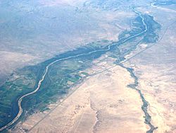
Rio Grande and Interstate 25 passing through Bernardo and Contreras, New Mexico. View from the northwest. Rio Puerco flowing toward the Rio Grande from the west.
Coordinates: 34°24′56″N106°50′39″W / 34.415637°N 106.84407°W / 34.415637; -106.84407
Country United States
State New Mexico
County Socorro
Elevation
4,741 ft (1,445 m)
Time zone UTC-7 (Mountain (MST))
  Summer (DST) UTC-6 (MDT)
Area code 505

Bernardo is an unincorporated community in Socorro County, New Mexico, United States, at the northern junction of US 60 and Interstate 25. Bernardo was named, circa 1902, after a friend of John Becker, a leading merchant in nearby Belen. [1] The main point of interest is the nearby Bernardo Wildlife Management Area, visited by large flocks of sandhill cranes and other birds. [2]

Contents

Location

Bernardo is situated in the Albuquerque Basin on the west bank of the Rio Grande, just north and upstream from that river's confluence with the Rio Puerco. There is an RV park and Horse Motel on the west side of I-25, across from the Waterfowl Management Area, on the old Route 66. [3] The landscape in the area consists of cultivated fields, grassland, marshland and ephemeral river. [4] Ladron Peak is just to the west and Bernardo State Game Refuge is just east of the settlement. [1] Collectors of rocks and minerals may find petrified and opalized wood on east side of the Rio Grande near the route 60 bridge. [5] Seven miles east of the Bernardo interchange is Micah Village, an intentional community.

Waterways

The United States Geological Survey operates a gauging station on the Rio Puerco near Bernardo. It routinely measures sediment concentrations of more than 600,000ppm, and over fifty years has measured an average of 113,000ppm, making Rio Puerco the fourth most sediment-laden river on Earth. [6] During drought periods, the Rio Puerco may dry up almost completely. [7] A conveyance channel of the Rio Grande runs past Bernardo. [8] In March 2007 the U.S. Senate set aside ten million dollars for flood damage repairs to levees in the region, including the levee between Abeytas and Bernardo. [9]

Birdlife

Sandhill cranes at nearby Bosque del Apache National Wildlife Refuge Grus canadensis -Bosque del Apache National Wildlife Refuge, New Mexico, USA -flying-8a (1).jpg
Sandhill cranes at nearby Bosque del Apache National Wildlife Refuge

The New Mexico Department of Water Game and Fish manages the Bernardo Wildlife Management Area, a unit of the Ladd S. Gordon Waterfowl Complex. It covers 1,700 acres (690 ha) that have been set aside to provide a winter habitat for waterfowl such as ducks and geese and for sandhill cranes. [2] A flock containing as many as 5,000 cranes may congregate at one time in the area. There are three observation decks along a 2.8 miles (4.5 km) dirt road near the Rio Grande. A separate 3 miles (4.8 km) loop goes through some of the huge, undeveloped area of grasslands along a deep channel of the Rio Puerco. [4]

Fields of parched corn and of alfalfa are planted to provide bird food. The birds are wary of predators such as coyotes who may lurk in the standing corn, but sections are pulled down for them so they can eat in safety. In the winter some of the fields may be flooded, or there may be ponds where the cranes roost for safety. Mule deer sometimes share the fields with the birds. [3]

Related Research Articles

<span class="mw-page-title-main">Rio Grande</span> Major river forming part of the US–Mexico border

The Rio Grande, known in Mexico as the Río Bravo del Norte or simply the Río Bravo, is one of the principal rivers in the southwestern United States and in northern Mexico. The length of the Rio Grande is 1,896 miles (3,051 km), making it the 4th longest river in North America by main stem. It originates in south-central Colorado, in the United States, and flows to the Gulf of Mexico. The Rio Grande drainage basin (watershed) has an area of 182,200 square miles (472,000 km2); however, the endorheic basins that are adjacent to and within the greater drainage basin of the Rio Grande increase the total drainage-basin area to 336,000 square miles (870,000 km2).

<span class="mw-page-title-main">Socorro County, New Mexico</span> County in New Mexico, United States

Socorro County is a county in the U.S. state of New Mexico. As of the 2020 census, the population was 16,595. The county seat is Socorro. The county was formed in 1852 as one of the original nine counties of New Mexico Territory. Socorro was originally the name given to a Native American village by Don Juan de Oñate in 1598. Having received vitally needed food and assistance from the native population, Oñate named the pueblo Socorro.

<span class="mw-page-title-main">Sandhill crane</span> Species of bird

The sandhill crane is a species of large crane of North America and extreme northeastern Siberia. The common name of this bird refers to habitat like that at the Platte River, on the edge of Nebraska's Sandhills on the American Great Plains. Sandhill Cranes are known to hang out at the edges of bodies of water, especially in the Central Florida region. The central Platte River valley in Nebraska is the most important stopover area for the nominotypical subspecies, the lesser sandhill crane, with up to 450,000 of these birds migrating through annually.

<span class="mw-page-title-main">Bosque del Apache National Wildlife Refuge</span> Wildlife refuge in New Mexico, USA

The Bosque del Apache National Wildlife Refuge is located in southern New Mexico. It was founded in 1939 and is administered by the U.S. Fish and Wildlife Service. It is a favorite spot to watch the migration of the sandhill cranes in the fall. The reserve is open year-round and provides safe harbor for its varied wildlife.

<span class="mw-page-title-main">Bosque</span> Type of forest found along rivers in the southwest United States

A bosque is a type of gallery forest habitat found along the riparian flood plains of stream and river banks in the southwestern United States. It derives its name from the Spanish word for 'woodlands'.

<span class="mw-page-title-main">Monte Vista National Wildlife Refuge</span> United States National Wildlife Refuge in southern Colorado.

Monte Vista National Wildlife Refuge is a United States National Wildlife Refuge located in southern Colorado. The refuge is located in the San Luis Valley south of the town of Monte Vista, Colorado in southeastern Rio Grande County, Colorado, in the watershed of the Rio Grande. It was established in 1953 by the Migratory Bird Conservation Commission to provide a habitat for wildlife, particularly waterfowl, in the San Luis Valley.

<span class="mw-page-title-main">Sierra Nacimiento</span> Mountains in New Mexico, US

The Sierra Nacimiento, or Nacimiento Mountains, are a mountain range in the northwestern part of the U.S. state of New Mexico. They are just west of the more prominent Jemez Mountains near the town of Cuba, and are separated from them by the Río Guadalupe and the Río de Las Vacas. This article will consider them as a unit together with the San Pedro Mountains, which are a smaller range contiguous with the Sierra Nacimiento on the north, and which are also part of the Nacimiento Uplift and lie at the edge of the greater San Juan Basin, which sits atop the Colorado Plateau. The combined range runs almost due north-south with a length of about 40 mi (65 km). The highest point in the combined range is the high point of the San Pedro Peaks, known unofficially as San Pedro Peak, 10,605 ft.

<span class="mw-page-title-main">Rio Hondo (Northern New Mexico)</span> River in Taos County, New Mexico, United States

The Rio Hondo is a river in northern New Mexico. A left tributary of the Rio Grande, it flows approximately 20 miles (32 km) from its headwaters high in the Sangre de Cristo Mountains near Wheeler Peak and the Taos Ski Valley to its discharge in the Rio Grande Gorge just west of the community of Arroyo Hondo. Portions of the Rio Hondo are prized as prime spots for bird-watching and fishing. The river was the subject of a 2005 study by the New Mexico Environment Department Surface Water Quality Bureau into the effects of wastewater from Taos Ski Valley, which is discharged from the Village of Taos Ski Valley Waste Water Treatment Plant.

<span class="mw-page-title-main">Rio Puerco (Rio Grande tributary)</span> River in New Mexico, United States

The Rio Puerco is a tributary of the Rio Grande in the U.S. state of New Mexico. From its source on the west side of the Nacimiento Mountains, it flows about 230 miles (370 km), generally south to join the Rio Grande about 20 miles (32 km) south of Belen and about 50 miles (80 km) south of Albuquerque. Its drainage basin is about 7,350 square miles (19,000 km2) large, of which probably about 1,130 square miles (2,900 km2) are noncontributing.

<span class="mw-page-title-main">Cosumnes River Preserve</span> Jointly managed protected area in the Central Valley of California

The Cosumnes River Preserve is a nature preserve of over 51,000 acres (210 km2) located 20 miles (30 km) south of Sacramento, in the US state of California. The preserve protects a Central Valley remnant that once contained one of the largest expanses of oak tree savanna, riparian oak forest and wetland habitat in North America. Agricultural development has changed the landscape from groves of oaks and tule marshes to productive farmlands.

<span class="mw-page-title-main">Puerco River</span> Waterway in Arizona

The Puerco River or Rio Puerco is a tributary of the Little Colorado River in northwestern New Mexico and northeastern Arizona. It flows through arid terrain, including the Painted Desert.

<span class="mw-page-title-main">Cabezon Peak</span>

Cabezon Peak is a large volcanic plug that is a prominent feature in northwestern New Mexico. It rises to 7,785 feet in elevation, and nearly 2,000 feet above the floor of the Rio Puerco Valley. Cabezon Peak is two miles south of the old ghost town of Cabezon and the Rio Puerco. This volcanic neck is formed of basalt and is part of the Mount Taylor volcanic field. A volcanic neck or plug is formed when magma from an existing volcano solidifies in the pipe or neck and the surrounding sediment is eroded away. Marine Cretaceous rocks of the Mancos Shale and Point Lookout Sandstone are exposed around the base of Cabezon Peak.

<span class="mw-page-title-main">Caballo Mountains</span>

The Caballo Mountains, are a mountain range located in Sierra and Doña Ana Counties, New Mexico, United States. The range is located east of the Rio Grande and Caballo Lake, and west of the Jornada del Muerto; the south of the range extends into northwest Doña Ana County. The nearest towns are Truth or Consequences and Hatch.

<span class="mw-page-title-main">Albuquerque Basin</span> Basin and ecoregion within the Rio Grande rift in central New Mexico

The Albuquerque Basin is a structural basin and ecoregion within the Rio Grande rift in central New Mexico. It contains the city of Albuquerque.

San Acacia is a small unincorporated community and census-designated place in Socorro County, New Mexico, United States. It was once a prosperous railway town, but is now largely deserted. There is a nearby diversion dam on the Rio Grande, important in irrigation.

The Ladd S. Gordon Waterfowl Complex is a group of four conservation area in New Mexico devoted to assisting birdlife in the region.

<span class="mw-page-title-main">Middle Rio Grande Conservancy District</span>

The Middle Rio Grande Conservancy District (MRGCD) was formed in 1925 to manage the irrigation systems and control floods in the Albuquerque Basin. It is responsible for the stretch of river from the Cochiti Dam in Sandoval County in the north, through Bernalillo County, Valencia County and Socorro County to the Elephant Butte Reservoir in the south. It manages the Angostura, Isleta and San Acacia diversion dams, which feed an extensive network of irrigation canals and ditches.

<span class="mw-page-title-main">Middle Rio Grande Project</span>

The Middle Rio Grande Project manages water in the Albuquerque Basin of New Mexico, United States. It includes major upgrades and extensions to the irrigation facilities built by the Middle Rio Grande Conservancy District and modifications to the channel of the Rio Grande to control sedimentation and flooding. The bulk of the work was done by the United States Bureau of Reclamation and the United States Army Corps of Engineers in the 1950s, but construction continued into the 1970s and maintenance is ongoing. The project is complementary to the San Juan-Chama Project, which transfers water from the San Juan River in the Colorado River Basin to the Rio Grande. Although distribution of water from the two projects is handled through separate allotments and contracts, there is some sharing of facilities including the river itself. The ecological impact on the river and the riparian zone was the subject of extended litigation after a group of environmentalists filed Rio Grande Silvery Minnow v. Bureau of Reclamation in 1999.

<span class="mw-page-title-main">San Antonio Mountain (New Mexico)</span> Volcanic mountain in New Mexico, US

San Antonio Mountain is a free-standing volcanic peak in Rio Arriba County, New Mexico. With an elevation of 10,908 feet, San Antonio Mountain is the highest peak within the Taos Plateau volcanic field, the largest volcanic field within the Rio Grande Rift valley.

<span class="mw-page-title-main">Bosque del Apache Wilderness</span>

Bosque del Apache Wilderness is a designated Wilderness Area on the Bosque del Apache National Wildlife Refuge in Socorro County, New Mexico. Managed by the U.S. Fish and Wildlife Service, the Wilderness, established in 1975, contains 30,427 acres distributed between three units.

References

Citations

  1. 1 2 Julyan 1996, p. 37.
  2. 1 2 Liddell & Hussey 2011, p. 143.
  3. 1 2 Archive for the ‘Bernardo’ Category.
  4. 1 2 Ausherman 2008, p. 291.
  5. Kimbler & Narsavage 1981, p. 29.
  6. Parsons & Abrahams 2009, p. 335.
  7. New Mexico Drought Photos ...
  8. Simons & Sentürk 1992, p. 254.
  9. Congress (U.S.) 2011, p. 7830.

Sources