
The Jervis Bay Territory is an internal territory of the Commonwealth of Australia. It was surrendered by the state of New South Wales to the Commonwealth Government in 1915 so that the Australian Capital Territory would have access to the sea.

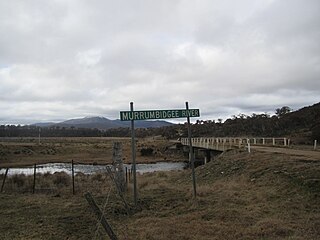
Murrumbidgee River, a major tributary of the Murray River within the Murray–Darling basin and the second longest river in Australia. It flows through the Australian state of New South Wales and the Australian Capital Territory. It descends 1,500 metres (4,900 ft) as it flows 1,485 kilometres (923 mi) in a west-northwesterly direction from the foot of Peppercorn Hill in the Fiery Range of the Snowy Mountains towards its confluence with the Murray River near Boundary Bend.

The Hunter Region, also commonly known as the Hunter Valley, is a region of New South Wales, Australia, extending from approximately 120 km (75 mi) to 310 km (193 mi) north of Sydney. It contains the Hunter River and its tributaries with highland areas to the north and south. Situated at the northern end of the Sydney Basin bioregion, the Hunter Valley is one of the largest river valleys on the NSW coast, and is most commonly known for its wineries and coal industry.

The Molonglo River, a perennial river that is part of the Murrumbidgee catchment within the Murray–Darling basin, is located in the Monaro and Capital Country regions of New South Wales and the Australian Capital Territory, in Australia.

The Monaro Highway is a highway in Victoria, New South Wales, and the Australian Capital Territory, in Australia.

Forde is a northern suburb of the Canberra, Australia district of Gungahlin. It is named in honour of Frank Forde, who served as Prime Minister of Australia for a week in 1945 following the untimely death of John Curtin. The suburb abuts the Mulligans Flat Woodland Sanctuary and is adjacent to the suburbs of Amaroo, Throsby and Bonner. The suburb is bound to the south and west respectively by Horse Park Drive and Gundaroo Road. Settlement of the suburb began in 2008 and it had an estimated population of 4,308 at the 2016 census.

Murray County was one of the original Nineteen Counties in New South Wales and is now one of the 141 Lands administrative divisions of New South Wales. It included the area which is now part of Canberra and as far north as Lake George and Yass. It was originally bounded on the west by the Murrumbidgee River, on the east by the Shoalhaven River and on the north by the Yass River. A large area of the county was transferred to the Commonwealth government in 1909 in the Seat of Government Acceptance Act to make part of the Australian Capital Territory, along with land in Cowley County. Since then, the ACT border is now part of the western boundary. Part of the ACT border is determined by property boundaries in the Parish of Keewong, in the County of Murray; specifically the southern end of portions 177, 218, 211, 36, and 38. This is mentioned in the Seat of Government Acceptance Act of 1909.
Cowley County is one of the 141 Cadastral divisions of New South Wales. It contains the locality of Cavan. It was originally bordered on the north, east and part of the south by the Murrumbidgee River, and on the west by the Goodradigbee River. A large part of the county was transferred to the Commonwealth to make the Australian Capital Territory in 1909, with the remaining part the area to the north-west of the ACT as far north as the Burrinjuck Dam, and thin strips of land along the western, southern and south-eastern borders of the ACT.

Scottsdale Reserve is a 1,328-hectare (3,280-acre) nature reserve on the Murrumbidgee River in south-central New South Wales, Australia. It is 79 kilometres (49 mi) south of Canberra, and 4 kilometres (2.5 mi) north of Bredbo. It is owned and managed by Bush Heritage Australia (BHA), which purchased it in 2006. The purchase was supportive of projects aiming to connect existing fragmented remnant habitat such as K2C. Since the 1870s up until 2006, the land was used for agriculture – primarily sheep grazing with some minor cropping. A significant component of the Reserve has been cleared of native vegetation.

Mulligans Flat Woodland Sanctuary is a protected area situated in the Gungahlin district in north Canberra in the Australian Capital Territory. It has several trails for walking, running and cycling. The sanctuary functions as a fieldwork site for researchers studying native ecology.

The Yathong Nature Reserve is a protected nature reserve that is also a nationally and internationally recognized biosphere situated in the central-western region of New South Wales, in eastern Australia. The 107,240-hectare (265,000-acre) reserve was listed by UNESCO in 1977 as a Biosphere Reserve under the Man and the Biosphere Programme (MAB). The reserve is significant for its biodiversity in both native plant and animal species. Cultural heritage and historical grazing activities add to the significance of this site as a conservation area.
The Burrinjuck Nature Reserve is a protected nature reserve on the south west slopes of New South Wales, Australia. The 5,250-hectare (13,000-acre) reserve is located adjacent to the Burrinjuck Dam, with 5,118 hectares of the reserve located on the northern side of the reservoir, and the remaining 89 hectares located on the southern side of the reservoir to the northeast of Black Andrew Nature Reserve. It includes land formerly managed as the Burrinjuck State Forest and Burrinjuck State Recreation Area.
The Black Andrew Nature Reserve is a protected nature reserve located on the south west slopes of New South Wales, Australia. The 1,559-hectare (3,850-acre) reserve is situated on the southern shore of Burrinjuck Dam on the Murrumbidgee River, an important reservoir for the Murrumbidgee Irrigation Area.
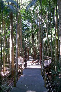
The Sea Acres National Park is a national park that is located in the Mid North Coast region of New South Wales, in eastern Australia. The 76-hectare (190-acre) park is situated near the town of Port Macquarie. The park is a popular tourist area with a 1.3-kilometre (0.81 mi) long boardwalk through a remnant of seaside rainforest. There is also an education centre and cafe. The park was initially declared as a nature reserve in 1987; and gazetted as a national park in October 2010.
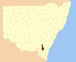
The Queanbeyan Nature Reserve is a protected nature reserve that is located in the Southern Tablelands region of New South Wales, in eastern Australia. The 67-hectare (170-acre) reserve is situated approximately 4 kilometres (2.5 mi) west-south-west of the City of Queanbeyan.

The Charcoal Tank Nature Reserve is a protected nature reserve in the central western region of New South Wales, Australia. The 86.4-hectare (213-acre) reserve is situated 10 kilometres (6.2 mi) south of West Wyalong and may be accessed via the Newell Highway and The Charcoal Tank Road. The reserve is an important refuge for native flora and fauna in a highly fragmented landscape, one in which the majority of the original vegetation has been removed.

The Cumberland Plain Woodland is one of six main indigenous woodland communities of Sydney, New South Wales, Australia, that comprises an open tree canopy, a groundcover with grasses and herbs, usually with layers of shrubs and/or small trees. Situated in the Cumberland Plain, it is made up of dry sclerophyll woodlands, grasslands and/or forests, reminiscent of Mediterranean forests and temperate grasslands.
Yaouk is a locality in the Snowy Monaro Region, New South Wales, Australia. It lies in open grassland valleys surrounded by mountains on both sides of the Murrumbidgee River, downstream from and east of the Tantangara Dam, north of Adaminaby, east of the Kosciuszko National Park and south of the Namadgi National Park in the Australian Capital Territory, but separated from it by the mountainous Scabby Range. It is about 110 km south of Canberra and about 75 km northwest of Cooma. At the 2016 census, it had a population of 25.

Scabby Range Nature Reserve is a heritage-listed protected area at Sams River Fire Trail, Yaouk, New South Wales, Australia. It was established on 3 December 1982 and added to the former Australian Register of the National Estate on 30 June 1992. It was added to the Australian National Heritage List as part of the Australian Alps National Parks and Reserves on 7 November 2008.

The ecology of Sydney, located in the state of New South Wales, Australia, is diverse for its size, where it would mainly feature biomes such as grassy woodlands and some sclerophyll forests, with a few pockets of mallee shrublands, subtropical and temperate rainforests (evergreen), heathlands, and wetlands. The combination of climate, topography, moisture, and soil influence the dispersion of these ecological communities across a height gradient from 0 to 200 metres. There are many hiking trails, paved and unpaved roads for exploring the many different biomes and ecosystems.
