
Granville is a suburb in western Sydney, in the state of New South Wales, Australia. Granville is located 18 kilometres (11 mi) west of the Sydney central business district, split between the local government areas of Cumberland City Council and the City of Parramatta.

Homebush is a suburb in the Inner West of Sydney in the state of New South Wales, Australia. It is located 12 kilometres west of the Sydney central business district, in the local government area of the Municipality of Strathfield. The Homebush area was initially called Liberty Plains. The historic railway station named after the suburb was for a time the early terminus of the Great Western Line. Nearby, Homebush Bay is a major inlet on the southern side of the Parramatta River northwest of Homebush. Homebush Bay was also the name of a separate, official suburb in former Auburn Council, most of which is now the suburb of Olympic Park, located to the northwest of Homebush and north of the separate suburb of Homebush West.

The Inner West of Sydney is an area directly west of the Sydney central business district, New South Wales, Australia. The suburbs that make up the Inner West are predominantly located along the southern shore of Port Jackson, stretching south to the shores of the Cooks River. The western boundary of the Inner West is approximately the A3 arterial road, which divides the Inner West from the Greater Western Sydney region. The Inner West is much larger than the Inner West Council local government area. The Inner West roughly corresponds with the Parish of Petersham and Parish of Concord, two cadastral divisions used for land titles.

Cumberland County is a county in the State of New South Wales, Australia. Most of the Sydney metropolitan area is located within the County of Cumberland.

St George Area is a region of Sydney, part of the southern suburbs of Sydney, in the state of New South Wales, Australia. The area includes all the suburbs in the local government area of Georges River Council and the part of Bayside Council which was Rockdale City prior to 2016. The eastern boundary of the district is Lady Robinson Beach on Botany Bay. The name "St George" derives from the cadastral Parish of St George, and the area was later covered by the St George County Council, the electricity supplier for the councils in this region.

Rydalmere(formerly "Field of Mars") is a suburb of Sydney, in the state of New South Wales, Australia. Rydalmere is approximately 21 kilometres north-west of the Sydney central business district in the local government area of the City of Parramatta. Rydalmere is part of the Greater Western Sydney region.

Wentworthville is a suburb in Sydney, in the state of New South Wales, Australia. Wentworthville is located 27 kilometres west of the Sydney central business district and is part of the Greater Western Sydney region. Wentworthville is split between the local government areas of the City of Parramatta and the Cumberland Council. Wentworthville is colloquially known as 'Wenty'.

Willoughby Parish, Cumberland is one of the 57 parishes of Cumberland County, New South Wales, Australia, a cadastral unit for use on land titles. The suburb of Willoughby and the City of Willoughby LGA are in a similar area. Willoughby Parish roughly covers the peninsula formed by the Lane Cove River, Sydney Harbour and Middle Harbour on three sides, with the northern boundary of the Parish roughly across the narrowest point of the peninsula. It roughly correlates with the region traditionally known as the "Lower North Shore", although that term is also sometimes used in a wider sense that includes land in neighbouring Hunters Hill Parish.
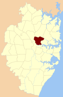
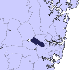
Field of Mars Parish is one of the 57 parishes of Cumberland County, New South Wales, a cadastral unit for use on land titles. While the name is mostly forgotten as a region name today, it has given the name to the modern suburb of Marsfield and the reserve in the area. It is centred on Carlingford and also includes Epping, Telopea and Ermington. Its southern boundary is the Parramatta River.

Liberty Plains Parish is one of the 57 parishes of Cumberland County, New South Wales, a cadastral unit for use on land titles. It is bounded by Parramatta Road in the north; the boundary between Flemington and Homebush, a small part of Cooks River and Liverpool Road in the east; the Hume Highway also in the south; and Woodville Road in the west. It includes the suburbs of Homebush West (Flemington), part of Strathfield, Auburn, Regents Park, Potts Hill, Sefton, Chester Hill, Bass Hill and Lidcombe. It also includes the Rookwood Cemetery. Before the parish was proclaimed in 1835, the Liberty Plains district was in the same area. The name had been given when the first settlers had desired a settlement midway between Parramatta and Sydney city. The name is still used on a motor inn in the area. In the 1851 census there were 49 houses and 270 people in the Liberty Plains parish.

St Lawrence Parish is one of the 57 parishes of Cumberland County, New South Wales, Australia, a cadastral unit for use on land titles. It is one of the four small parishes in the Sydney city area. Unlike the other three parishes, St Lawrence was not named after a church, but instead due to confusion over the naming, the parish gave its name to the Christ Church St Laurence. This had been controversial in the 19th century, as it was mistakenly thought that the Anglican church had been given a Catholic saint's name.
St Philip Parish is one of the 57 parishes of Cumberland County, New South Wales, a cadastral unit for use on land titles. It is located on the western part of the original colony at Sydney Cove, which was to the west of the Tank Stream. It is one of the four small parishes in the Sydney city area and is named after the church of St Philip's. It includes the southern end of the Sydney Harbour Bridge, The Rocks, Dawes Point and Millers Point. It is bounded by Sydney Harbour in the north, King Street in the south, George Street in the south-east, and what was once the Tank Stream in the east. The northern end of Darling Harbour is the boundary in the west. It includes Wynyard railway station.

St Luke Parish is one of the 57 parishes of Cumberland County, New South Wales, a cadastral unit for use on land titles. It is bounded by Prospect Creek in the north-east, Georges River in the south-east, and Cowpasture Road in the west. It was named after the Anglican church of St Lukes in Liverpool, which was completed in 1819. The parish is mentioned in various legislation dealing with property law for the city of Liverpool.
The metropolis of Sydney is informally subdivided into a number of geographic regions. These areas sometimes, but not always, roughly coincide with official boundaries of suburbs, local government authorities, or cadastral units, and some of the customary regions do not have well defined boundaries at all. Some commonly referred to regions overlap: for example, "Canterbury-Bankstown" is often referred to as a region, but it is also part of the "South Western Sydney" region. The regions themselves are not used as a formal jurisdiction, and do not have administrative or legislative bodies.

Prospect Hill is a heritage-listed hill in Pemulwuy and Prospect in the greater western region of Sydney, New South Wales, Australia. Situated about 30 kilometres west of central Sydney, the hill is Sydney's largest body of igneous rock and is higher than the ridges of the Cumberland Plain around it, with its present-day highest point being 117 metres high, although before its summit was quarried away it rose to a height of 131 metres above sea level.
Toongabbie Creek, an urban watercourse that is part of the Parramatta River catchment, is located in Greater Western Sydney, New South Wales, Australia.

The Darling Mills Creek, an urban watercourse that is part of the Parramatta River catchment, is located in Greater Western Sydney, New South Wales, Australia.

Devlins Creek, an urban watercourse that is part of the Parramatta River catchment, is located in Northern Suburbs region of Sydney, Australia.
Terrys Creek, an urban watercourse that is part of the Lane Cove River catchment, is located in Northern Suburbs region of Sydney, Australia. It was named after Edward Terry who served as the first mayor of Eastwood municipality.
The Cumberland City Council is a local government area located in the western suburbs of Sydney in the state of New South Wales, Australia. The Council was formed on 12 May 2016 from the merger of parts of the Cities of Auburn, Parramatta, and Holroyd.
