Park 12

Last updated

Angas Memorial in Angas Gardens, a tribute to the memory of the colonists George Fife Angas and John Howard Angas Angas Memorial in Angas Gardens(GN08347).jpg
Angas Memorial in Angas Gardens, a tribute to the memory of the colonists George Fife Angas and John Howard Angas

Park 12, (also referred to by its Kaurna name Karrawirra, meaning "river red gum forest") [1] is one of the 29 Parks that make up the Adelaide Park Lands. It consists of 55.5 hectares bounded by North Terrace, Frome Road, Sir Edwin Smith Avenue and King William Road [2]

Contents

Bisected by the River Torrens, the northern part of the Park contains the University playing fields.

Along North Terrace, the southern part of the Park contains the University of South Australia (City East campus), the University of Adelaide (main campus), the Art Gallery, the Museum, the State Library, the War Memorial, Government House, the Boer War Memorial, the Jubilee 150 Walkway, and numerous statues.

The southern part also contains the Torrens Parade Ground, Jolly's Boat House, and a number of Rowing Club boathouses.

Park 12 is home to the Peace Park, [3] Angas Gardens, [4] Roberts Reserve, Grundy Gardens, [5] the Cross of Sacrifice Garden, [6] the South Australian Naval Memorial Garden, [7] Lady Esther Lipman Gardens, [3] Pioneer Women's Memorial Garden, [8] Town Clerk’s Avenue/ Walk and the Pathway of Honour. [9]

Buildings

Buildings in Park 12 North of Victoria Drive [10] include:

DescriptionOwner/licence holder
Gardeners Shed (Brick & Stone)Adelaide City Council
Jolley's Boathouse Restaurant [11] Lessee – Jolley’s Boathouse Bistro Pty Ltd
Lunch Room & Toilet
(Victoria Avenue Police Station) [12]
Adelaide City Council
Gardeners Shed (Brick & Stone)Adelaide City Council
Pumphouse BunkerAdelaide City Council
Gardeners Shed (Brick & Stone)Adelaide City Council
Gardeners Shed (Wood & Iron)Adelaide City Council
Adel Uni Pavilion [13] Adelaide City Council
Adelaide Uni BuildingLicence Holder – University of Adelaide
Adel Uni ShedLicence Holder – University of Adelaide
Adelaide Uni Score Board/Store
(Dean Dawson Memorial Scorers Box & Plaque) [14]
Licence Holder – University of Adelaide
Lounders Boathouse
(Popeye's Boathouse) [15]
Lessee - Keith A & Elma H Altmann and Tony T & Lidija B Shuman
Prince Alfred College Rowing Club [16] Lessee - Prince Alfred College Incorporated
Adelaide Uni Rowing Building [17] Lessee - The University of Adelaide
CBC Rowing Club [18] Lessee - The Christian Brothers Incorporated
Torrens Rowing Club Building [19] Lessee - Torrens Rowing Club Incorporated
Adelaide H.S. Rowing Club [20] Lessee - Minister for Education & Children’s Services
St Peters College Rowing Club [21] Lessee - The Church of England Collegiate School of St Peters
Implement ShedAdelaide City Council
Sewer Vent House (Frome Road)SA Water
Pump House (at the Zoo Bridge)Adelaide City Council
University Footbridge
University Footbridge over River Torrens River Torrens Showing University Bridge(GN08684).jpg
University Footbridge over River Torrens

Located in the River Torrens portion of the Park, a dramatic cantilevered footbridge over the River Torrens of much picturesque charm and presence. Designed by the South Australian Railways department by engineers John Adrian Farghar and Reginald Bridgland with plans carrying the signature of the chief engineer of the Railways, Robert Hall Chapman. Construction of the footbridge proceeded with monies from the Council as part of its commitment to the state's centenary celebrations, and with a gift of £2,000 from Misses E and L Waite. The footbridge was opened on 9 August 1937. Currently listed as a State Heritage Place. [22]

Formal parks, gardens and paths

Pathway of Honour

Located between Kintore Avenue and King William Road, adjacent to the northern Government House grounds wall. Consists of a narrow sliver of land with a partially curved pedestrian pathway with associated war memorial plaques and stones. It was a pedestrian route that evolved in the 1920s and was formalised in the 1980s to honour war fallen.

Town Clerk’s Avenue / Walk

An axial pedestrian pathway from Sir Edwin Smith Avenue and Angas Gardens, leading to Frome Road, it was developed c.1917 with tree planting and pathway formation.

Angas Gardens

Angas Gardens Angas Gardens looking NE.jpg
Angas Gardens

Located east off King William Road between War Memorial Drive and the River Torrens, the gardens feature the JH & GF Angas Statue and Memorial by WR Cotton (1915), [23] and Robert Hannaford's statue of Simpson and his donkey. The gardens are named after South Australian pioneers and pastoralists John Howard Angas and George Fife Angas. [24]

Roberts Place

Located on the corner of Frome Road and Sir Edwin Smith Avenue, and an original extension of McKinnon Terrace. A triangular portion of land originally conceived as a formal garden centred upon a mature Moreton Bay Fig tree. Named after retired American merchant and South Australia Colonization Commissioner Josiah Roberts. [24]

Grundy Gardens

Located between Frome and King William Roads and War Memorial and Victoria Drives. [24]

Pennington Gardens East

Located between King William Road, Pennington Terrace and Sir Edwin Smith Avenue. A triangular shaped garden that was severely modified in 1919 onwards with the imposition of the Women’s War Memorial Garden. Named after South Australian Colonisation Commissioner James Pennington. [24]

Women’s War Memorial Garden

Located within Pennington Gardens East, the Women’s War Memorial was designed by Walter Torode in 1922. A formal rectangular configured 'Cross of Sacrifice' Garden reminiscent of a cathedral floor plan, designed by architect Alfred Wells and garden by Sir Herbert Baker. It includes the predominant use of low Olive hedging, Lavender, and Roses. The 11.6 metres (38 feet) high Cross of Sacrifice, designed by Sir Reginald Blomfield, at the north-west end is aligned to face the facade of St Peter's Cathedral. As a tribute, a scroll with the names of Adelaide's lost is enclosed within the base of the cross. The Remembrance Stone, designed by Sir Edwin Lutyens, is at the south-eastern end. The Cross was unveiled and Garden opened on 25 April 1922. The Stone was unveiled 25 April 1923. The Adelaide Anzac Day Commemorative March ends at this War Memorial. The Garden is currently listed as a State Heritage Place. [24] [25]

Pioneer Women’s Memorial Garden

Located in the Torrens Parade Ground portion between the Ground and the northern Government House grounds wall. A place identified and proposed in 1937 by the Women’s Council of South Australia as a venue to honour the pioneer women of South Australia, under a Committee chaired by Adelaide Miethke. Waikerie limestone statue sculptured by Olna Cohn and garden designed, planted and constructed by landscape designer Elsie Cornish in 1938. Statue unveiled 19 April 1941. Garden renovated by the Council in 2002. The Garden possesses associative significance to the foundation of the Royal Flying Doctor Service in Alice Spring. Currently listed as a State Heritage Place. [24]

Heritage Rose Garden

Developed in 1995–1996 and re-developed in 2017-2018,for the WFR conference in 2021.It is located on the north bank of the River Torrens, the garden was designed by the Heritage Roses in Australia, Adelaide group. [26]

See also

Notes

  1. Karrawirra 'river red gum forest', Adelaide City Council "Archived copy". Archived from the original on 20 November 2010. Retrieved 12 March 2018.{{cite web}}: CS1 maint: archived copy as title (link) CS1 maint: bot: original URL status unknown (link)
  2. Legal Framework and Land Control Details, Section 2.1, "Community Land Management Plan: Karrawirra (Park 12)", Pg 7.
  3. 1 2 "Peace Park". Adelaide's Top 10 Parks. totaltravel.com.au. Archived from the original on 27 August 2006. Retrieved 4 December 2010.
  4. Adelaide - Statues and Memorials, State Library of South Australia
  5. Grundy Gardens: "Place ID 14544". Australian Heritage Database . Australian Government.
  6. Memorial Gardens, Adelaide, showing Cross of Sacrifice, State Library of South Australia
  7. Canberra Reunion 1995 Archived 28 September 2007 at the Wayback Machine
  8. Pioneer Women's Memorial Garden - Main Entrance Archived 6 December 2010 at the Wayback Machine
  9. Overview, Section 1.2, "Community Land Management Plan: Karrawirra (Park 12)", Pg 5.
  10. Buildings, Section 2.1, "Community Land Management Plan: Karrawirra (Park 12)", Pg 8.
  11. Jolley's Boathouse:
    Located in the River Torrens portion of the Park, the two-storey Jolley's Boathouse and restaurant composed within a timber and sheet metal clad structure dating from the 1910s following the 1914 fire of the original Jolley's Boathouse.
    CLMP Karrawirra (Park 12), pg 17.
  12. Victoria Avenue Police Station:
    Located in the River Torrens portion of the Park, positioned in the north-west corner of Victoria Drive overlooking the River Torrens, a single-storey rendered-brick, cream-coloured structure featuring portico, wrought iron security bars on windows, and red terra cotta roof tiling all composed in a Spanish architectural style. Designed and erected in 1928 to serve as a Water Police Station to police watercraft and water-based recreational activities on the River Torrens, its Spanish architectural style is similar to the Hartley Building in Kintore Avenue erected in the late 1920s, and it was in use until 1956. It is now used by the Gardeners as a lunch room, office and for storage.
    CLMP Karrawirra (Park 12), pg 18.
  13. University of Adelaide 'Pavilion':
    Located in the University Oval portion of the Park, a prominent and elegantly designed grand stand structure including 5 gables, wrought iron metal strap seats, Mintaro slate steps, wrought iron support posts, and plaque.
    CLMP Karrawirra (Park 12), pg 16.
  14. Dean Dawson Memorial Scorers Box & Plaque:
    Located in the University Oval portion of the Park on the edge of the oval, a small two-storey cricket scorers box with plaque recording Dean Dawson as the Captain of the first University of Adelaide Inter-Varsity Football Team in 1904, and donated by KT Hamilton as erected in 1920. This box replaced an earlier box, and was donated by Alex J Melrose in 1920.
    CLMP Karrawirra (Park 12), pg 16.
  15. Popeye’s Boathouse:
    Located in the River Torrens portion of the Park on the River Torrens, a single-storey green-painted timber and red-painted galvanised-roofed rectangular structure with feature finial dating from the 1910s associated with the Popeye licence.
    CLMP Karrawirra (Park 12), pg 17.
  16. Prince Alfred College Boathouse:
    Located in the University Oval portion of the Park, a two-storey gabled iron-roofed structure sited on War Memorial Drive overlooking the River and erected in c.1930. While the College and the Old Collegians Association had been active in rowing prior to 1930, it was the enthusiasm of rower HWA Miller than enabled the Association to advance £1,250 to construct a boat house and to buy rowing boats. An Edwardian red and white painted timber slat structure with red painted gabled corrugated iron roof erected, and opened on 10 December 1930 by ex-Headmaster WR Bayly.
    CLMP Karrawirra (Park 12), pg 17.
  17. University of Adelaide Boathouse:
    Located in the University Oval portion of the Park, a two-storey gabled iron-roofed structure sited on War Memorial Drive overlooking the River. Designed in an Edwardian style by architects English & Soward. Robert Barr Smith funded the "handsome boathouse," measuring 18.2 x 9.1m, at a cost of £750. The boatshed included a balcony that provided views of the Lake and a finishing line for races and electric lighting. Extensively changed and altered since 1910.
    CLMP Karrawirra (Park 12), pg 17.
  18. Christian Brothers College Boathouse:
    Located in the University Oval portion of the Park, a nondescript red-brick two-storey structure sited on War Memorial Drive overlooking the River. Erected in 1961 by builders Blunden & Co at a cost of £8,000.
    CLMP Karrawirra (Park 12), pg 17.
  19. Torrens Rowing Club Boathouse:
    Located in the River Torrens portion of the Park next to Jolley's Boathouse, a contemporary two-storey red-brick structure, with club formation origins dating back to 1903.
    CLMP Karrawirra (Park 12), pg 17.
  20. Adelaide High School Boathouse:
    Located in the River Torrens portion of the Park on the River Torrens, a two-storey skillion-roofed red-brick structure with balcony erected in the 1970s replacing an earlier structure.
    CLMP Karrawirra (Park 12), pg 17.
  21. Collegiate of St Peter Boathouse:
    Located in the River Torrens portion of the Park on the River Torrens, a two-storey red-brick structure with gabled roof in one portion and skillion on the other.
    CLMP Karrawirra (Park 12), pg 17.
  22. CLMP Karrawirra (Park 12), pg 17.
  23. 13. JH & GF Angas Memorial by WR Cotton 1915, Historical Walking Trail : Famous Faces and Commemorative Places, Adelaide City Council.
  24. 1 2 3 4 5 6 CLMP Karrawirra (Park 12), pg 15.
  25. 16. Women's War Memorial by Walter Torode 1922, Historical Walking Trail : Famous Faces and Commemorative Places, Adelaide City Council.
  26. CLMP Karrawirra (Park 12), pg 16.

Related Research Articles

River Torrens River in Australia

The River Torrens, is the most significant river of the Adelaide Plains. It was one of the main reasons for the siting of the city of Adelaide, capital of South Australia. It flows 85 kilometres (53 mi) from its source in the Adelaide Hills near Mount Pleasant, across the Adelaide Plains, past the city centre and empties into Gulf St Vincent between Henley Beach South and West Beach. The upper stretches of the river and the reservoirs in its watershed supply a significant part of the city's water supply.

Port River River in Australia

The Port River is part of a tidal estuary located north of the Adelaide city centre in the Australian state of South Australia. It has been used as a shipping channel since the beginning of European settlement of South Australia in 1836, when Colonel Light selected the site to use as a port. Before colonisation, the Port River region and the estuary area were known as Yerta Bulti by the Kaurna people, and used extensively as a source of food and plant materials to fashion artefacts used in daily life.

Adelaide Park Lands Parks in Adelaide

The Adelaide Park Lands are the figure-eight of land spanning both banks of the River Torrens between Hackney and Thebarton and separating the City of Adelaide area from the surrounding suburbia of greater metropolitan Adelaide, the capital city of South Australia. They were laid out by Colonel William Light in his design for the city, and originally consisted of 2,300 acres (930 ha) "exclusive of 32 acres (13 ha) for a public cemetery". One copy of Light's plan shows areas for a cemetery and a Post and Telegraph Store on West Tce, a small Government Domain and Barracks on the central part of North Tce, a hospital on East Tce, a Botanical Garden on the River Torrens west of North Adelaide, and a school and a storehouse south-west of North Adelaide.

Government House, Adelaide

Government House, located in Adelaide on the corner of North Terrace and King William Road, is the official residence of the governor of South Australia.

Lockleys, South Australia Suburb of Adelaide, South Australia

Lockleys is an inner western suburb of Adelaide, located on Kaurna land, in the City of West Torrens.

Botanic Park, Adelaide

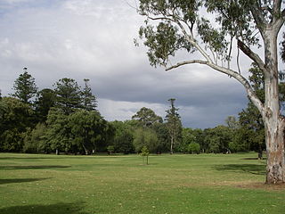
Botanic Park, part of Park 11, is a 34 hectare park in the Northeast Parklands of the South Australian capital of Adelaide. The park is bordered by Hackney Road and Frome Road. The University of South Australia, University of Adelaide, and the old Royal Adelaide Hospital are next to this park. The park also abuts the Adelaide Zoo and River Torrens.

Memorial Drive Park

Memorial Drive Park, more generally referred to as "Memorial Drive", is a tennis venue, located adjacent to the Adelaide Oval, in the park lands surrounding the centre of Adelaide, South Australia. Memorial Drive took its name from the winding avenue, known as War Memorial Drive, which separates the venue from the River Torrens.

University Oval, referred to by the University of Adelaide, Adelaide University Sports Association and various other groups, is a part of Park 12 in the Adelaide Parklands located across the River Torrens opposite the University of Adelaide. Park 12 is bounded by North Terrace, Frome Road, Sir Edwin Smith Avenue and King William Road

Park 10, also known as Bullrush Park and Warnpangga is one of the Adelaide Park Lands in the city of Adelaide, South Australia. It is one of the few parks to still be known most commonly by its assigned number, and is enclosed by McKinnon Parade, Bundey's Road, War Memorial Drive and Frome Road. The park is used extensively by University of Adelaide sporting clubs.

Jubilee 150 Walkway

The Jubilee 150 Walkway, also variously known as the Jubilee 150 Commemorative Walk, the Jubilee 150 Walk, and the Jubilee Walk, is a series of (initially) 150 bronze plaques set into the pavement of North Terrace, Adelaide in from to the Prince Henry Gardens. It was officially opened on 21 December 1986. It was commissioned as part of the celebrations commemorating the 150th anniversary of the founding of the Province of South Australia. The plaques contain the names and deeds of (initially) 170 people who made major contributions to the founding and development of South Australia. Since 1986, the Adelaide City Council has added four plaques.

Allenby Gardens, South Australia Suburb of Adelaide, South Australia

Allenby Gardens is a western suburb of Adelaide, South Australia. It is located in the City of Charles Sturt.

Torrens Island Island in South Australia

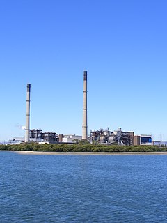
Torrens Island is an island in the Australian state of South Australia located in the Adelaide metropolitan area in the Port River Estuary about 15 kilometres (9.3 mi) northwest of the Adelaide city centre. Since European settlement of Adelaide in 1836, it has been used for a number of purposes.

The Park Centre for Mental Health Hospital in Queensland, Australia

The Park Centre for Mental Health is a heritage-listed psychiatric hospital at 60 Grindle Road, Wacol, City of Brisbane, Queensland, Australia. It is one of the largest psychiatric hospitals in Australia. The hospital provides a range of mental health services, including extended inpatient care, mental health research, education and a high security psychiatric unit. It was designed by Kersey Cannan and built from 1866 to 1923. It is also known as Goodna Hospital for the Insane, Goodna Mental Hospital, Woogaroo Lunatic Asylum, and Wolston Park Hospital Complex. It was added to the Queensland Heritage Register on 21 October 1992.

Benacre, Glen Osmond

Benacre is a house in Glen Osmond,, which was listed on the now-defunct Register of the National Estate. It is located at 6 Benacre Place.

North Adelaide Suburb of Adelaide, South Australia

North Adelaide is a predominantly residential precinct and suburb of the City of Adelaide in South Australia, situated north of the River Torrens and within the Adelaide Park Lands.

Popeye is the name given to a series of motor launches which take paying passengers on pleasure cruises on Torrens Lake, in the North Parklands of Adelaide, capital of South Australia. It is one of the city's "top tourist attractions".

Garden Island (South Australia)

Garden Island is an island in the Australian state of South Australia located about 14 kilometres (8.7 mi) north-west of the capital city of Adelaide in an estuary system within the Adelaide metropolitan area which drains into Gulf St Vincent. It is notable as being a site for a mangrove forest, a landfill, a part of the site for the Multifunction Polis, a ship graveyard and a venue for recreational boating activities. It has enjoyed varying degrees of protected area status since 1973.

Creswell Gardens

The Creswell Gardens are located in the Adelaide Park Lands between the Adelaide Oval, War Memorial Drive, King William Road and St Peter's Cathedral. They were established in 1909 and named after South Australian sportsman John Creswell. The gardens contain a number of Adelaide's landmark features.

War Memorial Drive, Adelaide Road in Adelaide, South Australia

War Memorial Drive is a connecting road in the South Australian capital of Adelaide. It starts from Bundeys Road near Princess Highway, runs in a western direction following the River Torrens, past the Adelaide Zoo, Adelaide University, Adelaide Oval and past Bonython Park into North Adelaide. Along the road, there are numerous statues of significant Australians and war heroes. The drive was dedicated and named after the heroes and victims of World War I.

References

34°54′51″S138°36′06″E / 34.914277°S 138.601662°E / -34.914277; 138.601662 Coordinates: 34°54′51″S138°36′06″E / 34.914277°S 138.601662°E / -34.914277; 138.601662