Wellington Square, North Adelaide

Last updated

Wellington Square/Kudnarto
OIC n adelaide wellington square.jpg
Australia South Australia City of Adelaide location map.svg
Red pog.svg
TypeSquare
Location North Adelaide, South Australia
Coordinates 34°54′26″S138°35′29″E / 34.9073°S 138.5915°E / -34.9073; 138.5915
Created1837 (1837)

Wellington Square, also known as Kudnartu and officially Wellington Square/Kudnarto, is a public square in the Adelaide suburb of North Adelaide, South Australia, in the City of Adelaide. It is roughly at the centre of the largest of the three grids which comprise North Adelaide.

Contents

It is one of six squares designed by the founder of Adelaide, Colonel William Light, who was Surveyor-General at the time, in his 1837 plan of the Adelaide city centre and North Adelaide. The square was named in 1837 by the Street Naming Committee after the Duke of Wellington, and in 2003 it was assigned a second name, Kudnartu, in the Kaurna language of the original inhabitants, as part of the Adelaide City Council's dual naming initiative. Kudnarto was a Kaurna woman from the Clare District. Hers was the first official Aboriginal/settler marriage in South Australia. [lower-alpha 1]

History

Pre-colonial history

The Adelaide area was inhabited long before European settlement in 1836 by one of the tribes which later came to be known as the Kaurna people, or Adelaide tribe. [1]

As Wellington Square

The square was named on 23 May 1837 after Arthur Wellesley, 1st Duke of Wellington, Irish-born field marshal and statesman, victor at Waterloo and Prime Minister of the United Kingdom from 1828 to 1830, [2] who is credited with securing the passage of the South Australia Foundation Act through the British House of Lords in 1834. [3] Colonel Light, first Surveyor-General of South Australia and a member of the Street Naming Committee, had briefly served under Wellington as a junior staff officer, [4] a Deputy Assistant Quartermaster General (DAQMG),[ citation needed ] during the Peninsular War. Light's 1837 plan of Adelaide included Wellington Square. [5]

Dual naming

In March 2003, as part of the City of Adelaide's dual naming project in association with the University of Adelaide, the square was assigned the name "Kudnartu", officially "Wellington Square/Kudnarto", [6] [7] to commemorate a Kaurna woman from the Crystal Brook area called Kudnarto, [8] [9] who married a settler, a shepherd named Tom Adams, in January 1848 at the Registry Office in Waymouth Street. [2] This was the first recorded official Aboriginal/settler marriage in the colony of South Australia. [10]

Kudnarto

Kudnarto's name (Kaurna: Kudnartu) means "third born if female". [11]

Also known as Mary Ann Adams, Kurdnatu had attended the "Native School Establishment" (later re-purposed as the Destitute Asylum) in Kintore Avenue, Adelaide, to learn "the arts of domestic life and household duties", and subsequently taught the illiterate Adams to write. They had two sons, Tom (born 1849) and Tim (1852), but they and their father were left destitute after Kudnartu's death at about 23 years old, around 1855, after land allocated to Kudnarto was repossessed by the government. Kudnarto continues to have many descendants, [12] [2] including:

Today

Wellington Square is one of only two of Light's six squares, Whitmore Square being the other one, which still retain the original configuration, neither having been dissected by roads like the others. [15] The square has jacaranda trees, roses, and cherry trees, and the walking trail around the perimeter is about 700 metres (770 yd). [2]

Further reading

Footnotes

  1. Spelled "Konarto" in the Register of Births, Deaths & Marriage, Book 1, page 333

Related Research Articles

The Kaurna people are a group of Aboriginal people whose traditional lands include the Adelaide Plains of South Australia. They were known as the Adelaide tribe by the early settlers. Kaurna culture and language were almost completely destroyed within a few decades of the British colonisation of South Australia in 1836. However, extensive documentation by early missionaries and other researchers has enabled a modern revival of both language and culture. The phrase Kaurna meyunna means "Kaurna people".

<span class="mw-page-title-main">Victoria Square, Adelaide</span> Public square in the centre of Adelaide, South Australia

Victoria Square, also known as Tarntanyangga, is the central square of five public squares in the Adelaide city centre, South Australia.

<span class="mw-page-title-main">History of Adelaide</span>

This article details the history of Adelaide from the first human activity in the region to the 20th century. Adelaide is a planned city founded in 1836 and the capital of South Australia.

<span class="mw-page-title-main">Adelaide Park Lands</span> Parks in Adelaide

The Adelaide Park Lands comprise the figure-eight configuration of land, spanning both banks of the River Torrens between Hackney and Thebarton, which encloses and separates the City of Adelaide area from the surrounding suburbia of greater metropolitan Adelaide, the capital city of South Australia. They were laid out by Colonel William Light in his design for the city, and originally consisted of 2,300 acres (930 ha) "exclusive of 32 acres (13 ha) for a public cemetery". One copy of Light's plan shows areas for a cemetery and a Post and Telegraph Store on West Terrace, a small Government Domain and Barracks on the central part of North Terrace, a hospital on East Terrace, a Botanical Garden on the River Torrens west of North Adelaide, and a school and a storehouse south-west of North Adelaide.

Nunga is a term of self-identification for Aboriginal Australians, originally used by Aboriginal people in the southern settled areas of South Australia, and now used throughout Adelaide and surrounding towns. It is used by contrast with Gunya, which refers to non-Aboriginal persons. The use of "Nunga" by non-Aboriginal people is not always regarded as appropriate.

Kaurna is a Pama-Nyungan language historically spoken by the Kaurna peoples of the Adelaide Plains of South Australia. The Kaurna peoples are made up of various tribal clan groups, each with their own parnkarra district of land and local dialect. These dialects were historically spoken in the area bounded by Crystal Brook and Clare in the north, Cape Jervis in the south, and just over the Mount Lofty Ranges. Kaurna ceased to be spoken on an everyday basis in the 19th century and the last known native speaker, Ivaritji, died in 1929. Language revival efforts began in the 1980s, with the language now frequently used for ceremonial purposes, such as dual naming and welcome to country ceremonies.

<span class="mw-page-title-main">Tjilbruke</span> Creation being in Kaurna (an Aboriginal Australian group) mythology

Tjilbruke is an important creation ancestor for the Kaurna people of the Adelaide plains in the Australian state of South Australia. Tjilbruke was a Kaurna man, who appeared in Kaurna Dreaming dating back about 11,000 years. The Tjilbruke Dreaming Track or Tjilbruke Dreaming Trail is a major Dreaming trail, which connects sites from within metropolitan Adelaide southwards as far as Cape Jervis, some of which are Aboriginal sacred sites of great significance.

<span class="mw-page-title-main">Montefiore Hill</span> Hill in North Adelaide, South Australia

Montefiore Hill is a small hill in North Adelaide, South Australia, which affords a view over the Adelaide city centre.

<span class="mw-page-title-main">Light Square</span>

Light Square, also known as Wauwi, is one of five public squares in the Adelaide city centre. Located in the centre of the north-western quarter of the Adelaide city centre, its southern boundary is Waymouth Street, while Currie Street crosses its northern tip, isolating about a quarter of its land. Morphett Street runs through the centre in a north–south direction.

<span class="mw-page-title-main">Rymill Park</span>

Rymill Park / Murlawirrapurka, and numbered as Park 14, is a recreation park located in the East Park Lands of the South Australian capital of Adelaide. There is an artificial lake with rowboats for hire, a café, children's playground and rose garden, and the Adelaide Bowling Club is on the Dequetteville Terrace side. The O-Bahn passes underneath it, to emerge at the western side opposite Grenfell Street.

<span class="mw-page-title-main">Hindmarsh Square</span> Public square in Adelaide, South Australia

Hindmarsh Square/Mukata is one of five public squares in the Adelaide city centre, South Australia. It is located in the centre of the north-eastern quarter of the city, and surrounds the intersection of Grenfell and Pulteney streets, near the eastern end of the Rundle Mall. Pirie Street forms the southern boundary of the square.

<span class="mw-page-title-main">Adelaide city centre</span> Suburb of Adelaide, South Australia

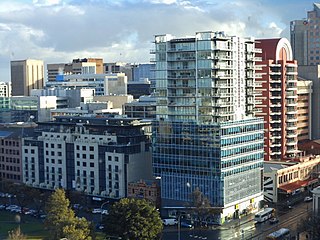
Adelaide city centre is the inner city locality of Greater Adelaide, the capital city of South Australia. It is known by locals simply as "the City" or "Town" to distinguish it from Greater Adelaide and from the City of Adelaide local government area. The population was 15,115 in the 2016 census.

<span class="mw-page-title-main">Whitmore Square</span>

Whitmore Square, also known as Iparrityi, is one of five public squares in the Adelaide city centre, South Australia. Occupying 2.4ha, it is located at the junction of Sturt and Morphett streets in the south-western quarter of the Adelaide city grid.

<span class="mw-page-title-main">Hurtle Square</span> Public squares in Adelaide, Australia

Hurtle Square, also known as Tangkaira, is one of five public squares in the Adelaide city centre, South Australia. Located in the centre of the south-eastern quarter of the city, it surrounds the intersection of Halifax and Pulteney streets. Its north edge is bounded by Carrington Street.

Morphett Street is a main street in the west of the city centre of Adelaide, South Australia, parallel to King William Street and numbered from north to south. At its northern end it is part of the West End of Adelaide, a thriving cultural and entertainment precinct, with the Lion Arts Centre on the south-western corner of its junction with North Terrace.

Rundle Park / Kadlitpina, also known as Park 13, is a part of the Adelaide Park Lands in Adelaide, South Australia. It was known as Rundle Park until its Kaurna name was assigned as part of the dual naming initiative by Adelaide City Council in 2003. The park is bounded by East Terrace, Botanic Road (north), Dequetteville Terrace (east) and Rundle Road (south).

Point Pearce, also spelt Point Pierce in the past, is a town in the Australian state of South Australia. The town is located in the Yorke Peninsula Council local government area, 194 kilometres (121 mi) north-west of the state capital, Adelaide.

<span class="mw-page-title-main">Gladys Elphick</span> Australian activist (1904–1988)

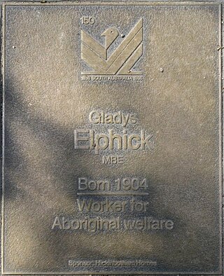
Gladys Elphick, also known as Auntie Glad, was an Australian Aboriginal woman of Kaurna and Ngadjuri descent, best known as the founding president of the Council of Aboriginal Women of South Australia, which became the Aboriginal Council of South Australia in 1973.

<span class="mw-page-title-main">Ivaritji</span> Kaurna elder, Kaurna language speaker and weaver

Ivaritji also known as Amelia Taylor and Amelia Savage, was an elder of the Kaurna tribe of Aboriginal Australians from the Adelaide Plains in South Australia. She was "almost certainly the last person of full Kaurna ancestry", and the last known speaker of the Kaurna language before its revival in the 1990s.

Kudnarto, also known as Mary Ann Adams, was an Aboriginal Australian woman of the Kaurna and Ngadjuri peoples who lived in the colony of South Australia. She is notable for being the first Aboriginal woman to legally marry a colonist in South Australia, making legal history in 1848, and for having many notable descendants.

References

  1. "Kaurna People". Adelaidia. 20 March 2017. Retrieved 1 July 2019.
  2. 1 2 3 4 Amery, Rob. "Walking Trail Wellington Square/Kudnartu" (PDF). Information as supplied by Dr. Robert Amery, 1997. City of Adelaide. Retrieved 7 December 2019.
  3. "History of Adelaide Through Street Names". History of South Australia website. Archived from the original on 14 June 2008. Retrieved 25 July 2008.
  4. "Light, William (1786–1839)". Australian Dictionary of Biography online. National Centre of Biography, Australian National University. Retrieved 25 July 2008.
  5. Margaret Anderson (31 December 2013). "Light's Plan of Adelaide 1837". adelaidia.sa.gov.au. History SA. Retrieved 5 May 2018. Copy of William Light's Plan of Adelaide, 1837, Held by the History Trust of South Australia, HT2001.166, adelaidia.sa.gov.au
  6. "Kaurna Placename Meanings within the City of Adelaide". University of Adelaide. Kaurna Warra Pintyanthi. Archived from the original on 22 September 2021.
  7. Note: Pronunciation can be listened to here
  8. "Local Intelligence". South Australian Register . Vol. XI, no. 741. South Australia. 23 June 1847. p. 3. Retrieved 1 February 2024 via National Library of Australia.
  9. "Easy walking trail in Wellington Square/Kudnartu". City of Adelaide. 12 May 2019.
  10. "City squares recognise women from the past". City of Adelaide. 19 March 2018.
  11. Amery, Rob; Williams, Georgina Yambo (March 2009). "18. Reclaiming Through Renaming: The Reinstatement of Kaurna Toponyms in Adelaide and the Adelaide Plains" (PDF). The Land is a Map: Placenames of Indigenous Origin in Australia. edited by Luise Anna Hercus, Jane Helen Simpson, and Flavia Hodges. (Pandanus Books, 2002) pp.255-276. doi: 10.22459/LM.03.2009.18 . Austlit entry
  12. 1 2 3 "Biography - Kudnarto". Indigenous Australia,'Kudnarto (c. 1832–1855)', Australian Dictionary of Biography, National Centre of Biography, Australian National University, by Peggy Brock.
  13. Hall, Robert (1996). "Timothy Hughes (1919–1976)". Australian Dictionary of Biography. Retrieved 31 January 2024. This article was published in hardcopy in Australian Dictionary of Biography, Volume 14, (Melbourne University Press), 1996
  14. Phillips, Sandra (10 January 2022). "Vince Copley had a vision for a better Australia – and he helped make it happen, with lifelong friend Charles Perkins". The Conversation . Retrieved 23 November 2023.
  15. Clark, Amber; Ramm, Kara-Lee; McInnes, Simone; Elton, Jude. "Whitmore Square, SA History Hub". History SA. Retrieved 6 December 2019.